Maryland Weather Update: Icy Conditions Ease, But a Bitter Cold Blast is Coming
A wintry mix of freezing rain and sleet is winding down across northern Maryland and the Baltimore metro area. Temperatures are now rising just above freezing,gradually diminishing the risk of hazardous travel. However, don’t get complacent – a significant cold snap is headed our way early next week. This article provides the latest updates and what you need to know to prepare.
Icy Roads: The Immediate Threat is Diminishing
The winter Weather Advisory for Carroll, Harford, Howard, and Baltimore Counties has expired. Light sleet and freezing rain created slick conditions Friday afternoon and evening. While the immediate Baltimore metro area is seeing improvement, be cautious.
* Remaining Risks: A few slick spots are still possible, especially in Harford and Cecil Counties, through early Saturday morning.
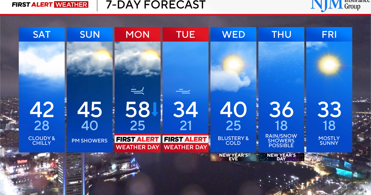
* Saturday Forecast: Expect a gray and chilly afternoon with temperatures peaking in the upper 30s and 40s.
* Sunday Outlook: More clouds are on the way, along with a chance of scattered light rain showers throughout the day.
Brace Yourself: A Deep Freeze Arrives Monday & Tuesday
Mark your calendars: Monday and Tuesday are first alert Weather Days. A dramatic temperature drop combined with gusty winds will create dangerous conditions. This isn’t just a typical cold spell; it’s a significant shift that requires preparation.
Here’s a breakdown of what to expect:
- Monday Morning: Initially breezy and unseasonably mild, with temperatures near 60°. Showers are likely during the morning and midday.
- Monday Afternoon: Conditions will rapidly deteriorate. Gusty winds will pick up, and temperatures will plummet into the 30s. Expect wind gusts of 35 to 45 mph.
- Monday Night & Tuesday: Bitterly cold temperatures and strong winds will persist. “Feels like” temperatures could drop into the single digits and teens. Wind gusts may exceed 45 mph in some locations.
What does this mean for you? Protect exposed skin,pipes,and pets. be prepared for potential power outages. Travel could become hazardous.
Preparing for Extreme Cold: A Checklist
To help you navigate this upcoming cold snap, consider these essential steps:
* protect Your Pipes: Insulate exposed pipes to prevent freezing and bursting.
* Check Your heating System: Ensure your furnace or heating system is functioning correctly.
* Stock Up on Supplies: Have a supply of non-perishable food, water, and essential medications on hand.
* dress in layers: When venturing outdoors, wear multiple layers of clothing to trap heat.
* Bring Pets Indoors: Protect your furry friends from the extreme cold.
* Charge Devices: Ensure your phones and other essential devices are fully charged in case of power outages.
Looking Ahead: Long-Term Trends & Maryland Weather Patterns
Maryland’s weather is notoriously variable, especially during the winter months. the state’s location, influenced by both continental and maritime air masses, often leads to rapid and dramatic shifts in temperature and precipitation.
* The Polar Vortex: While not directly impacting this event, the weakening of the polar vortex can contribute to colder-than-average temperatures in the eastern United States.
* Climate Change & Extreme Weather: Increasingly, we’re seeing more frequent and intense weather events, potentially linked to broader climate change patterns. Staying informed and prepared is more crucial than ever.
* El Niño Influence: The current El Niño pattern is contributing to a more active storm track, bringing increased precipitation to many parts of the country, including Maryland.
Frequently Asked Questions About Maryland’s Winter Weather
Q: What is the difference between freezing rain and sleet?
A: Freezing rain is liquid precipitation that freezes upon contact with a surface, creating a glaze of ice. Sleet is frozen precipitation that falls as ice pellets.
Q: how can I stay safe while driving in icy conditions?
A: Reduce your speed, increase your following distance, and avoid sudden braking or steering maneuvers.
Q: What should I do if my pipes freeze?
A: Shut off the water supply and slowly thaw the pipes with a hairdryer or warm towels. Never use an open flame.
**Q: