Spring Brings Elevated Severe Weather Risk to Northwest Arkansas and the River Valley
FAYETTEVILLE – As spring arrives, so too does an increased risk of extreme weather events across Northwest Arkansas and the River Valley. Residents should prepare for the possibility of intense thunderstorms, tornadoes, large hail, and heavy rainfall capable of causing flash flooding between March and May. This period marks one of the most active seasons for severe weather in the region, demanding heightened awareness and preparedness from communities.
The National Weather Service (NWS) explains that Arkansas’s geographic location contributes to this heightened risk. The state sits at a confluence of warm, moist air flowing north from the Gulf of Mexico and cooler, drier air masses moving south from the north. This collision of air masses creates an unstable atmospheric environment conducive to the development of strong thunderstorms and, potentially, tornadoes. The National Weather Service provides detailed forecasts and warnings for the region.
Authorities are particularly urging preparedness among Spanish-speaking families who may face language barriers when accessing critical weather information. Ensuring access to timely and understandable alerts is crucial for protecting all members of the community. The Arkansas Department of Emergency Management emphasizes the importance of proactive planning and staying informed through reliable sources.
Understanding the Threat: Tornadoes, Hail, and Flooding
Northwest Arkansas and the River Valley are susceptible to a variety of severe weather phenomena. Tornadoes, even as relatively infrequent, pose a significant threat due to their destructive potential. Large hail can cause damage to vehicles, homes, and crops. Heavy rainfall, often associated with slow-moving thunderstorms, can quickly lead to flash flooding, especially in low-lying areas and near rivers and streams. According to the Storm Prediction Center, Arkansas averages around 30 tornadoes per year, though the number can vary significantly. The Storm Prediction Center offers detailed information on tornado climatology and forecasting.
The potential for severe weather isn’t limited to tornadoes. Damaging wind gusts associated with thunderstorms can down trees and power lines, leading to widespread outages. Large hail, even if it doesn’t cause structural damage, can inflict significant economic losses on agricultural operations. Flash flooding remains a persistent threat, particularly in areas with poor drainage or those that have experienced recent heavy rainfall.
Preparing Your Home and Family
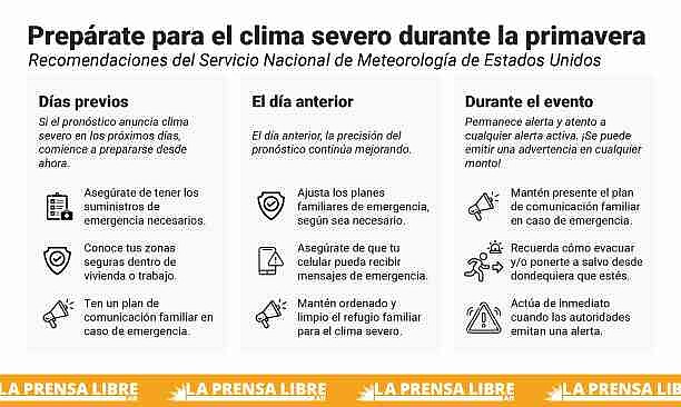
Local authorities and emergency management agencies recommend that every household develop a comprehensive emergency plan. This plan should include identifying the safest location within the home – ideally a basement, storm cellar, or an interior room on the lowest level without windows. Families should also designate a meeting point in case of evacuation and maintain an updated list of emergency contact numbers. It’s vital that all household members understand what to do if a weather alert is issued.
Activating Wireless Emergency Alerts (WEA) on mobile phones is another crucial step. WEA delivers official notifications about tornadoes, flash floods, and other critical alerts directly to your device. Understanding the difference between a “Watch” and a “Warning” is also essential. A “Watch” indicates that conditions are favorable for severe weather to develop, while a “Warning” means that severe weather is occurring or is imminent, and immediate action is required. Staying tuned to reliable news sources, local radio stations, and official weather apps is paramount during severe weather events.
Beyond planning, having a well-stocked emergency kit is vital. This kit should include at least one gallon of water per person per day, non-perishable food, a flashlight with extra batteries, a portable radio, a first-aid kit, and copies of important documents stored in a waterproof container. For those living in flood-prone areas, it’s crucial to never attempt to drive or walk through flooded streets – remember the mantra “Turn around, don’t drown.”
Staying Informed: Resources and Updates
Staying informed about changing weather conditions is paramount. The National Weather Service provides up-to-date forecasts, warnings, and advisories through its website, mobile app, and social media channels. Local news outlets and radio stations also play a critical role in disseminating timely weather information. The Arkansas Division of Emergency Management offers resources and guidance on preparing for and responding to various types of emergencies. The Arkansas Division of Emergency Management website provides comprehensive preparedness information.
In Flippin, Arkansas, as of March 11, 2026, the weather is overcast with a temperature of 50°F (10°C) and 80% humidity. Northwest winds are blowing at 18 mph with gusts up to 26 mph. The barometer reads 30.11 inches (1019.5 mb). The forecast for tonight calls for gradual clearing with a low around 32°F. Thursday is expected to be sunny with a high near 63°F. Detailed forecasts for Flippin are available from the National Weather Service.
Similarly, in Russellville, Arkansas, the current conditions are partly cloudy with a temperature of 62°F (17°C) and 56% humidity. North winds are blowing at 15 mph with gusts up to 25 mph. The forecast for tonight is mostly cloudy, then gradual clearing, with a low around 36°F. Thursday is expected to be sunny with a high near 61°F. Detailed forecasts for Russellville are available from the National Weather Service.
Looking Ahead: Continued Vigilance
Arkansas Flood Safety Awareness Week, running from March 9-14, 2026, serves as a timely reminder of the importance of preparedness. While the immediate forecast doesn’t indicate imminent severe weather, conditions can change rapidly. Staying vigilant, monitoring forecasts, and having a plan in place are essential for protecting lives and property. The potential for severe weather in Northwest Arkansas and the River Valley remains elevated throughout the spring months, requiring continued attention and proactive measures.
The next update on seasonal outlooks and potential severe weather risks will be released by the Storm Prediction Center on March 18, 2026. Residents are encouraged to stay informed and prepared as the spring season progresses. Share this information with your friends and family to help ensure everyone in the community is ready for whatever Mother Nature may bring.
Worth a look