
As spring approaches, many across Europe are enjoying an unusually mild winter. But, this pleasant spell is set to reach to an conclude, with a significant shift in weather patterns anticipated across France and surrounding regions. Current forecasts indicate a return to more typical March conditions, bringing increased rainfall, cooler temperatures, and even the possibility of late-season frosts. Understanding these evolving conditions is crucial for farmers, travelers, and anyone planning outdoor activities in the coming weeks.
The recent warmth has been largely attributed to a persistent high-pressure system, or anticyclone, dominating the weather across much of France since early March. This anticyclone has drawn in warm air from the south-east, creating remarkably mild temperatures for the time of year. However, this pattern is now breaking down, paving the way for a more unsettled period. The transition will be particularly noticeable after a period of unseasonably dry conditions, and will impact a wide range of activities, from agriculture to tourism. The coming weeks will require careful monitoring of weather updates to prepare for the changing conditions.
A Four-Week Outlook: From Calm to Potential Cold Snaps
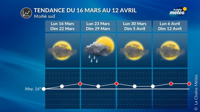
Long-range forecasts suggest a varied pattern over the next month. The immediate future, from March 16th to 22nd, promises a return to calmer, drier weather as the anticyclone re-establishes itself. Following this brief respite, however, conditions are expected to become more turbulent. The period between March 23rd and 29th will likely see the arrival of a “goutte froide” – a cold drop – over the western Mediterranean, bringing heavy rainfall to the Iberian Peninsula, North Africa, and southern France. Northern regions should remain relatively drier, though some showers are possible. Météo France reports that temperatures during this period will be seasonal, potentially dipping slightly below average.
Easter Weekend and the Risk of Late Frosts
The forecast for the period spanning March 30th to April 5th, encompassing the Easter weekend, remains somewhat uncertain. However, the most likely scenario points towards a return of the anticyclone, bringing calmer weather to France. This could translate into bright, sunny days with significant temperature swings – cool mornings giving way to pleasant afternoons. However, this very scenario also carries a risk: a late spring frost. With vegetation already responding to the recent mild temperatures, a sudden drop in temperatures could prove damaging to crops and gardens. Farmers are advised to monitor forecasts closely and take preventative measures if necessary. The potential for frost is particularly concerning given the early budburst observed in many fruit trees across the region.
Turbulence Ahead: Early April and Beyond
Looking further ahead, from April 6th to 12th, the forecast suggests a return to more unsettled conditions, particularly during the first week of school holidays for Zone A in France. An increase in Atlantic disturbances is expected, bringing periods of rain and slightly milder temperatures. Temperatures are anticipated to return to seasonal norms. This shift in weather patterns follows a period of exceptional warmth, with temperatures in February and early March significantly above average. Le Tribunal du Net reports that this prolonged mild spell has been driven by a powerful continental anticyclone influencing weather across France since March 2nd.
Impact on Agriculture and Outdoor Activities
The anticipated changes in weather will have a significant impact on various sectors. Farmers will need to closely monitor conditions to protect vulnerable crops from potential frost damage. The increased rainfall in late March and early April could also pose challenges, particularly for spring planting. Outdoor enthusiasts should be prepared for more variable conditions, with the possibility of showers and cooler temperatures. Travelers should check the latest forecasts before embarking on any outdoor adventures. The return to more typical March weather will also likely impact tourism, with fewer opportunities for sunbathing and outdoor dining.
The recent period of warm weather has also been linked to the transport of Saharan dust across Europe, giving the sky a hazy appearance. This phenomenon, driven by the strong southerly winds associated with the anticyclone, is expected to subside as the weather patterns shift. The dust, while visually striking, can also have implications for air quality and human health, particularly for individuals with respiratory conditions.
Key Takeaways
- A return to more typical March weather is expected across France.
- The period between March 23rd and 29th will likely see heavy rainfall in southern France.
- There is a risk of late spring frosts around the Easter weekend.
- The first week of April is forecast to be more unsettled, with increased rainfall.
The four-week weather trend, updated every Thursday around 5 PM, is subject to change. It’s crucial to stay informed with the latest forecasts from reliable sources such as Météo France and local weather services. The coming weeks will undoubtedly present a contrast to the recent mild spell, requiring adaptability and preparedness from all.
The next update to this forecast is scheduled for Thursday, March 19th. We encourage readers to share their observations and experiences with the changing weather conditions in the comments below.
Related reading