Jonathan Reed
Editor, News • London, United Kingdom • May 20, 2026
Hailstorm Blankets Mexico City and 4 States in Unprecedented Flooding: Images and Aftermath
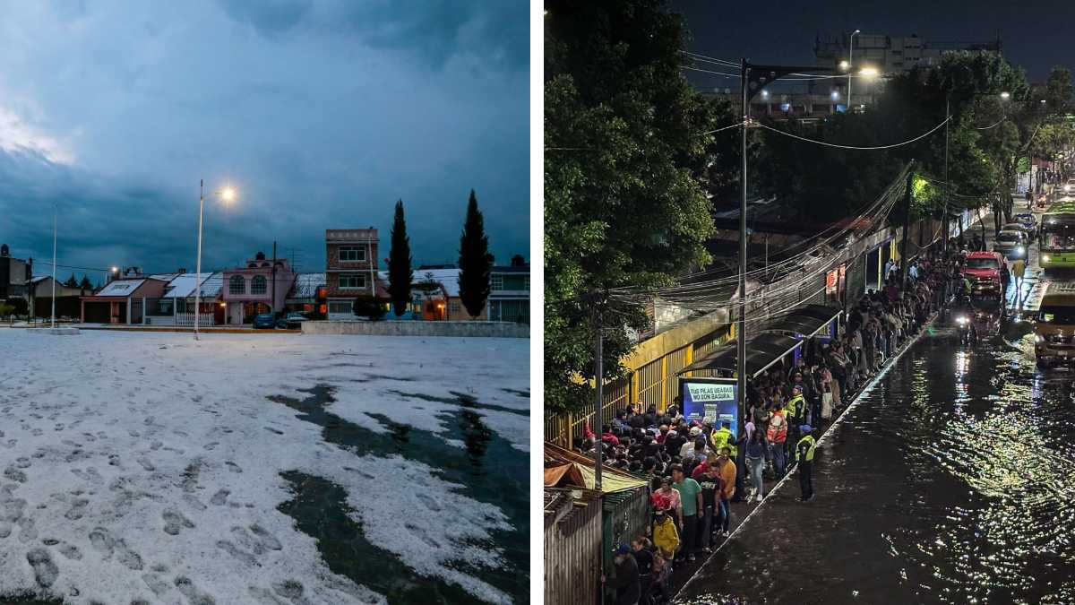
Mexico City and at least four surrounding states were paralyzed on Wednesday, May 20, 2026, after a rare and intense hailstorm transformed streets into icy rivers, submerged vehicles, and triggered localized flooding. Authorities confirmed no fatalities but warned of ongoing risks as cleanup crews worked through the night to restore critical infrastructure. The storm, which struck during a prolonged heatwave, underscored the growing volatility of Mexico’s climate patterns and tested the city’s drainage systems.
The National Meteorological Service (SMN) classified the event as “extreme,” with hailstones reaching diameters of up to 5 centimeters (2 inches)—large enough to cause property damage and disrupt transportation. Videos shared by residents showed streets in the capital’s eastern neighborhoods, including Valle de México, transformed into white landscapes, while the State of México (Edomex) reported flooding in at least nine municipalities, including Valle de Chalco. The storm’s intensity caught officials off guard, with local governments activating emergency protocols hours after the first reports of flooding.
This represents the second major weather-related crisis in Mexico City this month, following severe thunderstorms on May 12 that left 12,000 households without power and damaged roads in the Zona Metropolitana. Climate experts warn that such extreme weather events are becoming more frequent due to global warming, with Mexico’s capital—already prone to sinkage and poor drainage—particularly vulnerable.
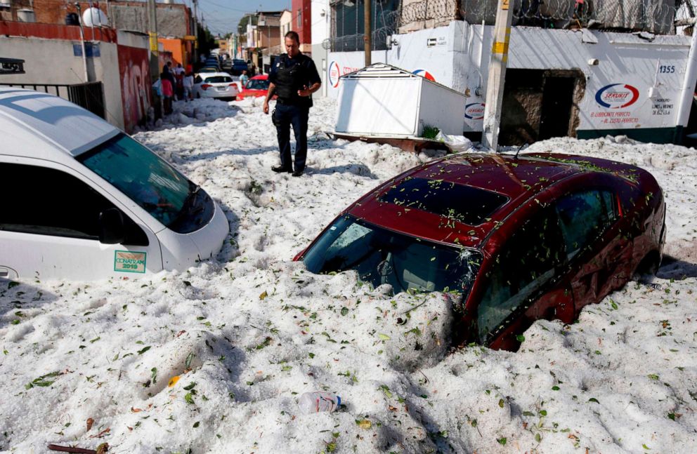
Video: Hailstorm coverage in Puebla City, May 26, 2024 (archival reference for storm patterns). Deutsche Welle
Storm’s Impact: Flooding, Traffic Halts, and Infrastructure Strain
By mid-afternoon, authorities in Mexico City confirmed that the storm had affected five boroughs (alcaldías), with the worst flooding reported in:

- Iztapalapa – A major drainage canal overflowed, submerging local markets and residential areas.
- Gustavo A. Madero – Primary roads, including Paseo de la Reforma, were closed to traffic for hours.
- Tláhuac – Rural communities near the ancient Chalco Lake bed experienced flash floods, isolating some homes.
The State of México (Edomex) declared a Yellow Alert (Preventive Phase) for nine municipalities, including:
- Ecatepec
- Nezahualcóyotl
- Chalco
- La Paz
- Tecámac
While no deaths were reported, local media cited three minor injuries—two from falling debris and one from a vehicle accident on a flooded road—according to the Secretaría de Seguridad Ciudadana. The city’s Environmental Protection Agency (SEDEMA) attributed the flooding to clogged drains exacerbated by the hail’s weight.
Why Mexico City’s Infrastructure Struggles with Heavy Rain
Mexico City’s geography—built on a former lake bed—combines with decades of underinvestment in drainage systems to create a perfect storm (literally) for flooding. The city’s drainage network, designed in the 19th century, was never intended to handle modern rainfall intensities. Climate models predict that by 2050, Mexico City could see a 30% increase in extreme precipitation events, according to a 2025 report by the National Water Commission (CONAGUA). The storm’s timing—during a heatwave—also highlighted the city’s vulnerability to rapid temperature shifts, which can trigger sudden downpours.
Authorities’ Response: Cleanup, Warnings, and Long-Term Planning
Mexico City’s mayor, Claudia Sheinbaum (who also serves as Mexico’s president-elect), addressed the crisis in a late-afternoon press conference, emphasizing prevention over reaction:

“We are working around the clock to clear drains and reinforce vulnerable areas. This storm is a wake-up call: we must accelerate our deep drainage project, which will modernize the system by 2028.”
The federal government deployed 150 municipal workers and 20 heavy machinery units to clear debris, while the Secretariat of Communications and Transportation reopened key routes by 8 PM local time. However, officials warned that some areas—particularly in Xochimilco—could remain inaccessible until Thursday.
In the State of México, Governor Delia González activated the State Civil Protection Plan, urging residents to avoid flooded areas and report emergencies via the 911 hotline. The storm also disrupted power in 1,200 homes across Edomex, with CFE (Federal Electricity Commission) restoring service to 80% of affected areas by midnight.
“It Looked Like Snow”: Residents Describe the Unprecedented Storm
Social media platforms exploded with videos and photos of the storm, with many residents comparing the hail to “snow in summer.” One video, shared by @CDMX_Alertas on X (formerly Twitter), showed a hailstone the size of a golf ball bouncing off a car windshield:
Video: Hailstorm footage from Gustavo A. Madero, May 20, 2026. @CDMX_Alertas
Maria López, a market vendor in Iztapalapa, told local media:
“I’ve lived here 20 years, and I’ve never seen hail like this. The ice was up to my ankles in some places. The city needs to fix the drains—this is the third time this month we’ve had flooding.”
While no major businesses reported closures, the storm disrupted daily life for thousands. Schools in affected areas, including the University of Guadalajara’s Mexico City campus, canceled classes for Thursday pending infrastructure assessments.
Climate Scientists Warn of Worsening Trends
Dr. Valeria Souza, a climatologist at the National Autonomous University of Mexico (UNAM), linked the storm to broader climate patterns:
“This event is consistent with projections for the Sixth IPCC Assessment: Mexico City is experiencing more frequent convection-driven storms due to higher surface temperatures. The heatwave we’ve had this month created unstable air masses, leading to rapid condensation and hail formation.”
Souza noted that similar storms have struck Puebla in recent years, including a 2024 hailstorm that left streets covered in ice during a heatwave—a phenomenon scientists call “cryovolcanic-like precipitation.”
What Happens Next? Cleanup, Investigations, and Future Preparedness
Over the next 48 hours, authorities will focus on:

- Infrastructure repairs: SEDEMA will conduct a full audit of drainage systems, with preliminary findings expected by May 23.
- Flood risk mapping: CONAGUA will update its real-time flood prediction models to include hail impact zones.
- Public safety briefings: The National Civil Protection System will host a press conference on May 22 to outline long-term resilience strategies.
Residents are advised to:
- Monitor SMN alerts for further storms.
- Report blocked drains to 5133-5151 (SEDEMA hotline).
- Avoid wading through floodwaters due to hidden debris.
Key Takeaways
- The May 20, 2026, hailstorm was the most severe in Mexico City since 2024, with hailstones up to 5 cm in diameter.
- Five boroughs and nine municipalities in Edomex were affected, with no fatalities but significant infrastructure damage.
- Climate experts attribute the storm to global warming, warning of increased extreme weather risks for Mexico City.
- Authorities are accelerating a $1.2 billion drainage modernization project, set for completion in 2028.
- Residents are urged to prepare for potential aftershocks, including power outages and road closures.
Have you experienced the storm’s aftermath? Share your photos or stories with us—tag #CDMXStorm2026 on social media or email [email protected]. For official updates, follow:
- @CDMX_Gob (Mexico City Government)
- @SMN_MX (National Meteorological Service)
- Protección Civil México
Next update: May 22, 2026 – Official post-storm assessment and drainage repair timeline.
Worth a look