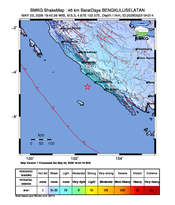
BENGKULU, Indonesia — Residents across the Bengkulu region were alerted on Saturday, May 23, 2026, as a seismic event measuring magnitude 5.3 struck off the southwestern coast. The tremor, which originated 64 kilometers southwest of Bengkulu Selatan, prompted immediate monitoring from national geological authorities tasked with tracking seismic activity in the Indonesian archipelago.
The event, recorded by the Badan Meteorologi, Klimatologi, dan Geofisika (BMKG), underscores the persistent geological volatility of the region. Indonesia sits atop the Pacific “Ring of Fire,” an area characterized by frequent tectonic shifts and volcanic activity. While local authorities have yet to issue a formal assessment regarding structural damage, the intensity of the shaking in the immediate vicinity of the epicenter has been categorized by intensity scales used to measure ground motion and human perception of seismic events.
Understanding Seismic Intensity in Bengkulu
According to preliminary data released by regional monitoring centers, the shaking was felt with varying degrees of intensity across the Bengkulu Selatan district. Seismic intensity scales, which differ from magnitude scales, measure the actual ground motion at specific locations rather than the total energy released at the source. The categorization of intensity III-IV indicates that the tremor was felt by many people indoors and resulted in the swaying of hanging objects, consistent with moderate seismic activity.

The Modified Mercalli Intensity (MMI) scale, which is frequently used by geologists to communicate the impact of earthquakes to the public, classifies intensity III as “felt quite noticeably by persons indoors, especially on upper floors of buildings,” while intensity IV is often described as “felt by many, with dishes, windows, and doors disturbed.” The reporting of such levels in Bengkulu Selatan suggests that while the event was significant enough to be widely noted by the local population, it remained within the range of moderate tectonic adjustments common to the Sunda Megathrust zone.
Geological Context and Regional Safety
The Bengkulu region remains one of the most seismically active areas in Southeast Asia. The interaction between the Indo-Australian Plate and the Eurasian Plate creates a complex subduction zone that frequently generates earthquakes of varying depths and magnitudes. The BMKG maintains a network of seismic stations to provide real-time updates and public advisories, which are critical for disaster mitigation and community preparedness.
For those residing in high-risk zones, the Indonesian government—through the Badan Nasional Penanggulangan Bencana (BNPB)—regularly emphasizes the importance of earthquake drills and the maintenance of emergency evacuation routes. Residents are encouraged to monitor official government channels, such as the BMKG website or mobile applications, for any updates regarding aftershocks or changes in regional seismic status. It is standard protocol for geological agencies to continue tracking the epicenter for potential secondary movements following a magnitude 5.3 event.
Preparedness and Public Information
As of Saturday, official statements have focused on the initial instrumental readings rather than reported casualties or infrastructure collapse. In the event of further seismic activity, authorities typically advise the public to follow the “Drop, Cover, and Hold On” protocol and to remain clear of structures that may have been weakened by previous tremors. Accurate information remains the primary defense against misinformation during the immediate aftermath of a natural disaster.

The BMKG continues to refine its seismic modeling to better predict the impact of such tremors on local infrastructure. For the most recent updates on this event, citizens should rely exclusively on the official information portals provided by the Indonesian government. We will continue to monitor the situation as further reports from the field become available.
If you have experienced the tremor, please ensure your safety by checking for structural integrity in your immediate area and following instructions from local disaster management agencies. We invite our readers to stay informed through verified channels and to share this information with those in affected districts.
Keep reading