The Royal Netherlands Meteorological Institute (KNMI) has issued a Code Geel (yellow code) warning for much of the Netherlands, as severe thunderstorms are expected to sweep across the country. The atmospheric instability is raising concerns regarding localized damage and potential water nuisance, prompting meteorologists to advise caution across several provinces.
As of Monday, June 1, 2026, weather patterns indicate a significant shift in conditions. While much of the nation prepares for heavy rainfall and lightning, current projections suggest that Zeeland may be one of the few regions to escape the immediate impact of these storm cells. However, the volatile nature of summer weather means that conditions can shift rapidly, and residents are encouraged to monitor official updates closely.
The primary risks associated with this weather system include intense lightning, sudden heavy downpours, and the potential for wind gusts. In certain southern and eastern regions, the threat is compounded by the possibility of hail, which can cause damage to vehicles, property, and vegetation.
Regional Impact and Developing Weather Patterns
The thunderstorm activity appears to be concentrated in specific corridors of the country. Reports indicate that provinces such as Overijssel and Gelderland have already experienced or are currently navigating the brunt of these convective cells. In the southern reaches of the country, particularly in Limburg, the warning is particularly acute, with meteorologists highlighting the triple threat of thunderstorms, strong wind gusts, and hail.

The movement of these storms is dynamic. While some areas in the east may see the most intense activity pass through relatively quickly, the risk of wateroverlast (water nuisance) remains high in low-lying areas and urban centers where drainage systems may be overwhelmed by sudden, high-intensity rainfall.
For residents in the affected provinces, the advice is to remain vigilant. The transition from relatively calm or warm conditions to severe convective activity can happen with very little warning, often preceded only by a sudden drop in temperature or a change in wind direction.
Understanding the KNMI Warning System
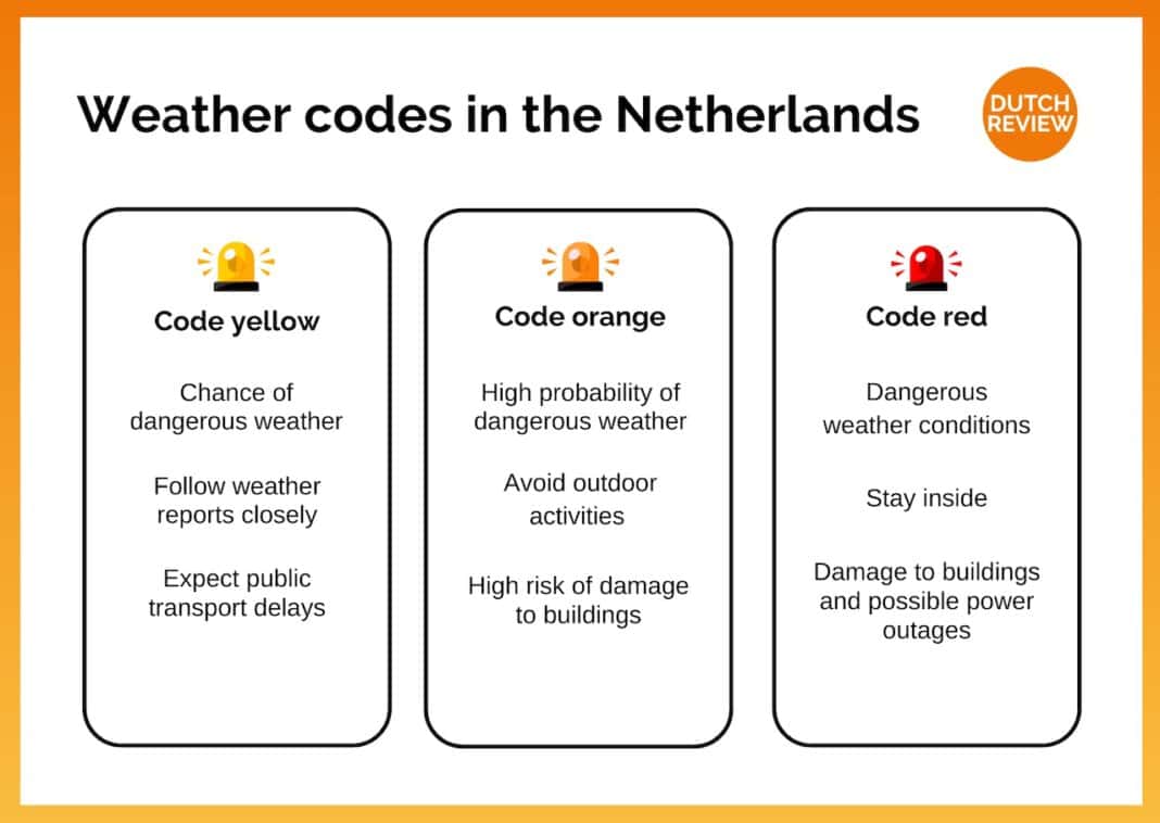
The KNMI utilizes an impact-based warning system to communicate the severity of weather events to the public. The color-coded system is designed to help citizens understand not just the weather phenomenon itself, but the potential consequences for their daily lives and safety.
- Code Geel (Yellow): This code is issued when there is a chance of dangerous weather. It serves as a signal to be alert, as the weather may cause localized disruption or minor damage.
- Code Oranje (Orange): This indicates a higher level of risk, where the weather could lead to more significant disruptions and potential damage to property or infrastructure.
- Code Rood (Red): The highest level of warning, issued when extreme weather poses a serious threat to life and widespread damage is expected.
The current Code Geel for thunderstorms focuses on the impact of the weather. The goal of the alert is to allow individuals and organizations to take preemptive measures—such as securing loose outdoor items or planning for travel delays—to limit the risk of injury and property damage.
Safety Guidance for Severe Thunderstorms
When severe thunderstorms are imminent, safety experts and meteorological officials recommend several practical steps to mitigate risk. Because lightning can strike miles away from the actual rain shaft, it is important to seek shelter as soon as thunder is heard.
Protecting Personal Safety
If you are outdoors when a thunderstorm begins, seek shelter immediately in a sturdy building or a hard-topped vehicle. Avoid open fields, tall trees, and bodies of water. If you are driving, pull over to a safe location away from trees or power lines if the weather becomes extreme, though remaining inside a vehicle is generally considered safe from lightning.
Mitigating Property Damage
To reduce the risk of damage from wind and hail, it is advisable to secure or bring indoors any lightweight outdoor furniture, garden tools, or decorations. In areas prone to heavy rainfall, ensure that gutters and drains are clear of debris to help facilitate water runoff and minimize the risk of localized flooding around your home.
Managing Water Nuisance
In the event of heavy downpours, be cautious of driving through flooded streets. Even a small amount of moving water can be powerful enough to stall a vehicle or sweep it off the road. Always prioritize visibility and traction, and avoid areas where water is visibly rising.
Key Takeaways for Residents
- Monitor Alerts: Keep a close eye on official KNMI updates for changes in warning levels or regional coverage.
- Prepare for Impact: Secure loose outdoor items and prepare for potential disruptions to transport and electricity.
- Stay Informed: Use local news and official weather apps to track the movement of storm cells in real-time.
- Prioritize Safety: Seek indoor shelter immediately upon hearing thunder.
As the weather continues to develop, the situation across the Netherlands remains fluid. The transition from the current warm conditions to these intense storm systems highlights the increasing unpredictability of seasonal weather patterns.
Next Official Update: Residents should check the KNMI website or official weather channels for the next scheduled advisory or any escalation in warning codes for the upcoming 24-hour period.
Have you experienced the impact of these storms in your area? Share your observations and safety tips in the comments below. Please share this article to help keep your community informed and safe.