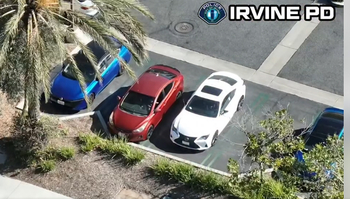
The Irvine Police Department successfully apprehended a suspected drunk driver following a high-speed pursuit that utilized a drone to track the vehicle’s movements. This incident highlights the growing role of unmanned aerial systems (UAS) in modern law enforcement, allowing officers to maintain visual contact with suspects while minimizing the risks associated with traditional high-speed ground chases.
According to official department records, the pursuit began when officers attempted to stop a vehicle suspected of driving under the influence. When the driver failed to yield and attempted to evade patrol cars, the department deployed a drone from its Drone as a First Responder (DFR) program. The technology provided real-time aerial surveillance, allowing ground units to back off while maintaining a tactical advantage, eventually leading to the safe arrest of the suspect without further incident.
How Drone as a First Responder Programs Work
The Irvine Police Department’s DFR program is designed to integrate aerial technology into daily operations to improve public safety and officer efficiency. These drones are often staged at strategic locations, allowing them to arrive at the scene of an emergency faster than a ground-based patrol vehicle. Once on-site, the UAS technology provides dispatchers and responding officers with a live, high-definition video feed, which aids in assessing the situation before personnel arrive.
.jpg/278px-Campus_of_the_University_of_California%2C_Irvine_(aerial_view%2C_circa_2006).jpg "How Drone as a First Responder Programs Work")
In the case of a fleeing vehicle, the drone serves as a “virtual tail.” By tracking the car from the air, the police can reduce the need for a dangerous, high-speed ground pursuit through residential streets. This tactical shift is increasingly adopted by municipal agencies across the United States to reduce the likelihood of traffic accidents and protect both pedestrians and officers during volatile encounters.
The Evolution of Aerial Surveillance in Law Enforcement
The integration of drones into police work represents a significant shift in how departments manage public safety technology. While traditional methods rely heavily on the line-of-sight capability of patrol officers, aerial assets provide a bird’s-eye view that is unaffected by ground-level traffic congestion or complex urban layouts. The Irvine police have emphasized that these programs are governed by strict operational protocols to ensure compliance with privacy laws and department policies.
Beyond vehicle pursuits, these systems are frequently utilized for search and rescue operations, large-scale event monitoring, and assessing crime scenes. The data captured by these drones is stored according to the department’s transparency and digital evidence policies, which are publicly available for review. This focus on accountability is a core component of how the department manages its technological footprint in the community.
Why Aerial Tracking Reduces Public Risk
The primary benefit of using a drone during a pursuit is the ability to de-escalate the situation. When a suspect realizes they are being tracked by a drone, the intensity of their flight often decreases because they can no longer easily evade police by weaving through traffic or turning into obscured areas. According to the National Highway Traffic Safety Administration (NHTSA), impaired driving remains a leading cause of traffic fatalities, making the rapid apprehension of DUI suspects a high priority for public safety.
By shifting from a ground-based pursuit to an aerial observation, the police department significantly lowers the probability of a collision. The drone can maintain a safe distance while providing precise coordinates to ground units, who then coordinate the stop at a location where it is safer to perform an arrest. This method effectively neutralizes the “cat-and-mouse” game that often characterizes traditional vehicle pursuits.
Future Developments and Community Oversight
The success of the Irvine drone program has drawn attention to the broader implementation of emerging technologies in local government. As departments continue to evaluate the efficacy of these programs, they are also engaging with community stakeholders to address concerns regarding civil liberties and the use of surveillance. The Irvine Police Department maintains a transparency portal that provides information on how these tools are deployed, ensuring that residents remain informed about the equipment used to keep the city safe.
Looking ahead, the department is expected to continue its evaluation of the DFR program’s impact on crime rates and response times. For residents interested in the latest updates or who wish to review the department’s operational guidelines, the Irvine Police Department’s official website serves as the primary source for all policy changes and program developments. We encourage readers to share their thoughts on the balance between technological innovation and privacy in the comments below.