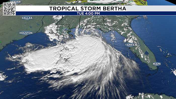
Tropical Storm Bertha is projected to make landfall Wednesday night in a coastal, lightly populated area of southeastern Louisiana, according to the National Weather Service. As the second named storm of the 2026 Atlantic hurricane season, Bertha is currently moving westward with maximum sustained winds of 50 mph.
Current Storm Status and Forecast
The National Hurricane Center reports the storm is moving at 6 mph. Forecasters expect the system to weaken as it pushes further into Texas, with the center of circulation arriving in the Houston area late Thursday. While Bertha is expected to bring tropical storm conditions to portions of the northern Gulf Coast, meteorologists do not anticipate the storm will strengthen into a hurricane.
By the time the system reaches southern Louisiana, projections indicate it may be downgraded to a tropical depression. Despite the weakening trend, the storm maintains a minimum pressure of 997 millibars.
Coastal Impacts and Warnings
A Tropical Storm Warning is currently in effect stretching from the Florida Panhandle to Morgan City, Louisiana, including metropolitan New Orleans and Lake Pontchartrain. Authorities have extended a Tropical Storm Watch to include parts of the southeastern Texas coastline from 11 a.m. Wednesday through 6 a.m. Friday.

Communities across the Gulf Coast have taken precautionary measures, including distributing sandbags and closing beaches. Double red flags have been raised at numerous locations, signaling that waters are closed to swimming due to dangerous surf and high rip-current risks.
Rainfall and Storm Surge Risks
The primary threats associated with Bertha include heavy rainfall, storm surge, and strong winds. Forecasters anticipate rainfall totals of 2 to 4 inches from western Florida to the southern Louisiana coastline, with isolated areas potentially receiving up to 6 inches. This level of precipitation carries a risk of flash flooding, particularly in urban areas.

For more on this story, see Tropical Storm Bertha Forecast to Hit Louisiana Coast Wednesday Night.
Storm surge projections include: * Louisiana: 2 to 4 feet near the mouth of the Mississippi River. * Central Gulf Coast: 1 to 3 feet in various locations. * Alabama and Mississippi: Minor surge potential of 1 to 3 feet, particularly during high tide.
In addition to flooding risks, seas as high as 6 feet could develop over coastal waters. In Mississippi, flood warnings have been issued for areas immediately along the coastline, with flood watches in place for the northern parts of Hancock, Harrison, and Jackson counties.
Emergency Preparedness
Officials from the National Hurricane Center and the U.S. Department of Homeland Security urge residents to maintain preparedness throughout the remainder of the season. Recommendations include establishing an evacuation plan, identifying emergency routes, and reviewing insurance policies to understand deductibles and coverage limits.
Residents are advised to avoid flooded roads, following the guidance to turn around, don't drown.
For further information, the public is encouraged to consult official resources such as the 2026 Hurricane & Flood Survival Guide and local weather updates. While the 2026 Atlantic season is predicted to have fewer storms than the 30-year average—partly due to a strong El Niño—experts warn that unusually warm Gulf waters continue to provide high energy for potential storm development.
Worth a look