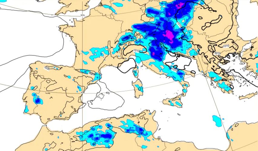
An intense heatwave dominating the Italian peninsula is finally set to ease following Ferragosto, as cooler currents from Northern Europe approach the Mediterranean and trigger widespread atmospheric instability, according to meteorological updates. While the holiday weekend will maintain scorching conditions with temperatures soaring past 38°C in several inland areas, mathematical forecasting models indicate a notable shift in trajectory for the incoming weather front, concentrating the most severe storms along the Adriatic coast and eastern regions.
The transition marks a temporary break from extreme African heat that has blanketed Italy for weeks. According to weather models, the incoming cooler air will collide with residual heat and humidity trapped across the Mediterranean basin, creating a significant temperature drop of 4 to 5°C across much of the country, with localized decreases reaching up to 6 to 8°C along the Adriatic strip. However, forecasters emphasize that this shift will not bring a dramatic autumn-like collapse, but rather a return closer to seasonal climatological averages.
Ferragosto Heat Peaks and Ministry of Health Advisories
Before the anticipated weather break arrives, the Ferragosto holiday weekend will bring searing heat across central regions and the Pianura Padana. Florence is projected to reach a high of 39°C, while Prato, Pistoia, and Terni are expected to peak at 38°C, according to regional forecasts. Temperatures of 37°C are forecasted for Lucca, Parma, Pisa, Reggio Emilia, Piacenza, and Benevento.
The Italian Ministry of Health has adjusted its heat health warning map to reflect a gradual atmospheric shift. Based on a combination of high temperatures and humidity levels, only Bari and Bolzano will maintain red-tier warnings for heatwave risks on August 15, with most other monitored cities dropping to yellow-tier alerts. This reduction signals the preliminary weakening of the dominant anticyclone before more dynamic weather systems move in.
Incoming Storms and Regional Impacts
Atmospheric instability will begin to manifest late Sunday, August 16, as the vanguard of cooler air presses against the Alpine arc. Afternoon and evening thunderstorms are expected to develop across northern and central mountain ridges before spilling into adjacent plains.
The acute phase of the maltempo will unfold between Monday, August 17, and the early hours of Tuesday, August 18. Updated tracking shows the fresh trough sliding down the eastern flank of the peninsula rather than taking a more westerly path. This trajectory will deliver a rapid sweep of showers and thunderstorms particularly hitting the Triveneto region and the Adriatic coast from Marche down to Puglia. According to meteorological analyses, strong thermal contrasts in these areas may produce intense phenomena, including frequent hail and sudden wind gusts.
Conversely, northwestern metropolitan areas such as Milan and Turin will experience minimal precipitation accumulations. Similarly, Rome and the Tyrrhenian coast will remain largely at the margins, though fast-moving showers remain possible across the Levante Ligure, northern Tuscany, Lazio, and Campania.
Midweek Pause and Forecasting Challenges
The active weather phase will prove relatively brief. By Tuesday afternoon and evening, conditions are expected to improve rapidly from the north as storms track toward the south and clear skies return under a rebounding high-pressure system. Yet this reprieve may be short-lived, with medium-term projections indicating a second, more potent Atlantic wave approaching around Friday, August 21, which could reintroduce organized rainfall and thunderstorms primarily across Northern Italy.
Meteorologists note that predicting these transitions has proven exceptionally complex due to the massive reservoir of heat and humidity accumulated across the Mediterranean basin. This trapped thermal layer acts as a buffer, forcing incoming northern cold fronts to slide along eastern margins and delaying the overall seasonal break. Residents and travelers are encouraged to consult official Civil Protection advisories and daily updates as local conditions evolve.
For ongoing updates on weather alerts and civil protection guidelines, readers can monitor announcements from the Italian Dipartimento della Protezione Civile. We invite our readers to share their local weather observations and discuss the forecast in the comments section below.