
Residents of Chicago are preparing for a weekend of stark atmospheric contrasts as the city transitions from a cool, overcast start to a significant temperature spike by Sunday. According to current meteorological data, the region will experience a period of stability characterized by cloud cover before a sharp rise in warmth and an increased probability of precipitation.
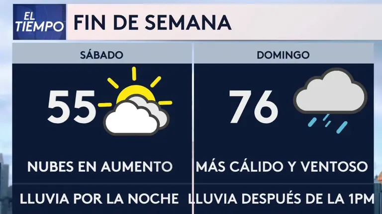
The Chicago weather forecast for the immediate window indicates that Friday and Saturday will remain relatively cool, with maximum temperatures hovering around 53°. F. While conditions will be primarily cloudy, the risk of significant rainfall remains low during the first half of the weekend, providing a brief window of dry weather for the Windy City.
However, this stability is expected to shift rapidly. By Sunday, the city will see a dramatic jump in temperature, reaching a high of 77°F. This warming trend will be accompanied by increased wind activity and a significantly higher chance of showers, marking a volatile end to the weekend period.
Friday and Saturday: Overcast and Cool
For Friday, April 10, the forecast specifies a mostly cloudy day with a maximum temperature of 53°F and a minimum of 36°F. The probability of precipitation is minimal at 4%, with northeast winds blowing between 5 and 10 mph. Humidity levels are expected to reach 70% during the day and climb to 85% overnight via Weather.com.

Saturday, April 11, is expected to mirror Friday’s daytime conditions. The high will again reach 53°F under mostly cloudy skies, though the chance of rain will increase slightly to 8%. Winds will shift to the east at 5 to 10 mph, and the UV index is projected to rise to 6 of 11. As the evening progresses into Saturday night, conditions will become cloudier with the rain probability jumping to 24% and temperatures dipping to a low of 46°F via Weather.com.
Sunday’s Temperature Spike and Wind Warnings
A significant weather shift is slated for Sunday, April 12. The mercury is expected to climb to a high of 77°F, representing a 24-degree increase from the previous day’s maximum. While the day will remain mostly cloudy, the most notable concern for residents will be the wind. South-southwest winds are forecast at 15 to 25 mph, with occasional gusts potentially exceeding 40 mph via Weather.com.
The warming trend will likely be short-lived as the atmosphere becomes more unstable. By Sunday night, the probability of precipitation increases sharply to 69%, with showers expected. The overnight low will be significantly warmer than previous nights, holding at approximately 61°F, with south winds continuing at 15 to 25 mph via Weather.com.
Weekend Weather Summary
| Date | High Temp | Low Temp | Rain Chance (Day/Night) | Wind Conditions |
|---|---|---|---|---|
| Friday, April 10 | 53°F | 36°F | 4% / 13% | NE 5-10 mph |
| Saturday, April 11 | 53°F | 46°F | 8% / 24% | E 5-10 mph / SE 10-15 mph |
| Sunday, April 12 | 77°F | 61°F | 24% / 69% | SSO 15-25 mph (Gusts >40 mph) |
Impact and Reader Guidance
The rapid fluctuation in temperatures—from the mid-50s to the upper 70s within 48 hours—is typical of spring patterns in the Midwest but can pose challenges for health and planning. Residents are advised to dress in layers for Friday and Saturday and to secure outdoor furniture or loose items on Sunday due to the forecast of gusts exceeding 40 mph.
For those planning outdoor activities on Sunday, while the warmth will be welcome, the high probability of Sunday night showers suggests that any evening events should have a backup indoor location. The increased UV index on Saturday (6 of 11) and Sunday (5 of 11) also indicates a need for sun protection despite the cloud cover.
The next confirmed weather checkpoint will be the update for Monday, April 13, to determine if the Sunday warmth persists or if the region returns to cooler spring averages.
Do you have a strategy for dealing with the Windy City’s volatile spring weather? Share your tips in the comments below or share this forecast with others in the Chicago area.