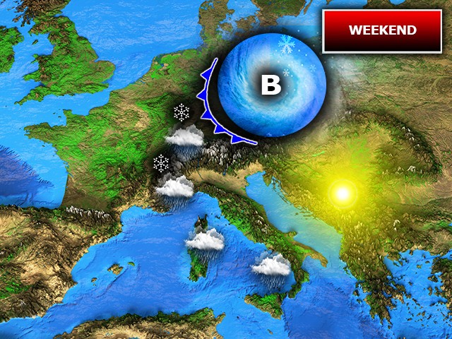
A late-season cold snap is poised to bring a return of wintry conditions to parts of Italy this weekend, with a significant drop in temperatures and the potential for snow at surprisingly low elevations. The approaching weather system, dubbed a “goccia fredda” – or cold drop – is expected to impact primarily northern regions, bringing unsettled weather and a renewed chill after a relatively mild early spring. This development comes as the remnants of a previous cyclonic circulation over the southern Mediterranean continue to influence weather patterns across the country.
The term “goccia fredda” refers to a mass of cold air aloft that becomes detached from the main atmospheric circulation, often forming over western Europe and then drifting southward towards the Mediterranean Sea. According to the Italian Wikipedia, these systems typically develop when a polar air front encounters the warmer, moister air over the Mediterranean, generating strong storms (Wikipedia – Goccia Fredda). This particular system is developing as high-pressure systems build over northern Europe, forcing the cold air southward. The impact of these systems can be significant, bringing heavy rainfall, strong winds, and even snow to lower altitudes.
Weekend Weather Outlook: Saturday’s Deterioration
The current cyclonic circulation influencing the southern Mediterranean will continue to draw colder air into Italy as the weekend approaches. A latest vortex, originating from northeastern Europe, is forecast to move north of the Alpine arc, isolating itself as a cold drop between France and the Iberian Peninsula. This pattern is typical for the transitional period following the spring equinox. The most significant impacts are expected across northern Italy, with a rapid deterioration in conditions beginning on Saturday, March 21st.
The alpine and pre-alpine areas will experience the first effects of the cold drop, with snow expected to fall as low as 600-700 meters. Meanwhile, rain, potentially heavy at times, is forecast for Piedmont and Liguria. The rest of northern Italy will see unstable conditions, characterized by alternating clouds, showers, and brief periods of sunshine. Central and southern Italy are expected to fare better, with only moderate variability and predominantly dry conditions. A noticeable drop in temperatures will accompany the worsening weather, particularly in the northern regions.
Sunday’s Shift: Focus on Sardinia and the Tyrrhenian Sea
By Sunday, March 22nd, the cold drop is predicted to move further west, reaching the Iberian Peninsula by evening. This shift will concentrate the most intense weather activity over the western part of Italy, marginally affecting the northwestern Alpine regions but more significantly impacting Sardinia and the areas of the lower Tyrrhenian Sea. Centro Meteo Italiano reports that this movement will bring increased instability to these areas.
However, the rest of Italy isn’t expected to remain entirely unaffected. Widespread cloud cover will alternate with occasional clearings, particularly in the northeastern regions and along the Adriatic side of central Italy. The cold drop’s arrival follows a period of unsettled weather across Europe, with a previous polar air intrusion impacting central-western Mediterranean regions over the preceding weekend, bringing snow to relatively low elevations in northwestern Italy and the major islands.
Understanding the “Goccia Fredda” Phenomenon
The “goccia fredda” is a recurring meteorological event in the Mediterranean region, particularly during the autumn and spring months. As explained by Il Giornale, it’s essentially a mass of particularly cold air that isolates itself at high altitudes, separating from the main atmospheric currents (Il Giornale – Goccia Fredda). This isolation makes its trajectory difficult to predict with precision over longer periods. When this cold air mass comes into contact with the warmer, more humid air over the Mediterranean Sea, it can generate intense weather phenomena, including heavy rainfall and strong winds.
The formation of a cold drop is often linked to a blocking high-pressure system over northern Europe, which disrupts the normal west-to-east flow of air. This blocking pattern forces cold air to be channeled southward, increasing the likelihood of these isolated cold air masses developing over the Mediterranean. The current situation reflects this pattern, with a robust anticyclone positioned between the British Isles, the North Sea, and the Baltic Sea, effectively blocking the usual zonal flow and exposing the Mediterranean to colder air from the east.
Impact on Travel and Outdoor Activities
The anticipated snowfall at lower elevations could disrupt travel in mountainous areas, particularly in the Alps and pre-Alpine regions. Motorists are advised to check road conditions before traveling and to be prepared for potential delays or closures. Ski resorts may benefit from the fresh snowfall, extending the ski season, but conditions could also be hazardous for backcountry skiers and snowboarders. Outdoor activities, such as hiking and camping, are also likely to be affected by the colder temperatures and increased precipitation.
Regional Variations in Precipitation
While the northern regions are expected to bear the brunt of the precipitation, Sardinia and the Tyrrhenian coast will also experience significant rainfall on Sunday. The potential for localized heavy downpours raises concerns about flash flooding, particularly in urban areas and along riverbanks. Residents in these areas are advised to monitor weather updates and take necessary precautions to protect themselves and their property. The intensity of the rainfall could vary considerably depending on the precise track of the cold drop, making accurate forecasting crucial.
The approaching cold drop serves as a reminder that even as spring progresses, the Mediterranean region remains susceptible to sudden shifts in weather patterns. Staying informed about the latest forecasts and taking appropriate precautions is essential for ensuring safety and minimizing disruption during these periods of unsettled weather. The Italian meteorological service will continue to monitor the situation closely and provide updated forecasts as the cold drop evolves.
The next official update from Centro Meteo Italiano is expected on Monday, March 23rd, providing a more detailed assessment of the cold drop’s impact and the subsequent weather outlook. Readers are encouraged to share their experiences and observations in the comments section below, and to stay tuned to World Today Journal for further updates on this developing weather situation.
Keep reading