
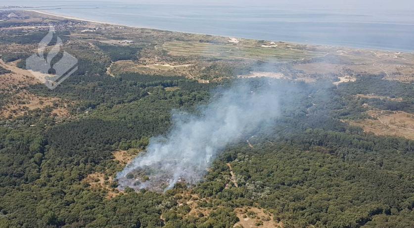
A massive wildfire has erupted at the Artillerie Schietkamp (Question) military training ground near ‘t Harde in the province of Gelderland, triggering emergency alerts across multiple Dutch provinces and forcing the closure of a major arterial highway. The blaze, which broke out on Wednesday morning, has produced an expansive plume of smoke visible from great distances and detectable across large portions of the Netherlands.
Emergency services are currently battling multiple hotspots within the nature reserve, with officials warning that the scale of the fire is “exceptionally large.” Due to prevailing weather conditions and the volatility of the terrain, firefighting efforts are expected to continue for several days. The incident has caused significant disruption to regional transport and prompted urgent health advisories for residents in the surrounding areas.
The response involves a coordinated effort between various regional fire brigades and the Royal Netherlands Air Force, which has deployed heavy machinery to combat the flames. As the fire remains uncontrolled, the Veiligheidsregio Noord- en Oost-Gelderland (Safety Region North and East Gelderland) continues to monitor the situation and manage a surge in emergency calls from concerned citizens.
Emergency NL-Alerts and Public Health Advisories
As the smoke drifted westward, the Dutch government issued an NL-Alert—the national emergency broadcasting system—to residents in several regions to mitigate health risks. The alerts were sent to inhabitants of Noord- and Oost-Gelderland, Flevoland, and the Gooi- en Vechtstreek according to reports from the national broadcaster NOS.
Public health officials have advised residents in these affected areas to take immediate precautions to avoid inhaling smoke and particulate matter. The specific guidance issued includes:
- Keeping all windows and doors firmly closed.
- Turning off all mechanical ventilation systems.
- Remaining indoors until further notice.
The Veiligheidsregio Noord- en Oost-Gelderland reported a significant peak in telephone traffic to the emergency dispatch center following the initial reports. While the cause of the fire remains unknown, officials have not yet confirmed whether the blaze was ignited intentionally or by natural causes.
Infrastructure Disruptions and Air Traffic Impact
The wildfire has caused severe logistical paralysis in the region, most notably on the A28 motorway. The highway has been closed in both directions between ‘t Harde and Wezep due to dangerously low visibility caused by the thick smoke plume per official traffic updates. Motorists are being diverted, and the ANWB has closed several secondary roads in the vicinity to ensure emergency vehicles have unimpeded access to the military training ground.
The impact of the fire has extended into the skies. Luchtverkeersleiding Nederland (Air Traffic Control the Netherlands) confirmed that the smoke has affected flight operations. While the smoke has not created “dangerous situations” that would require grounding flights, pilots have been in active communication with controllers to request permission to either fly over or navigate around the smoke columns to maintain visibility.
Scale of the Blaze and Military Intervention
The severity of the situation was highlighted by Edwin Kok, the National Coordinator for Nature Fire Management at the Netherlands Institute for Public Safety. Kok described the incident as an “exceptionally large fire,” noting that the environmental conditions are complicating the containment process.
To augment the ground-based firefighting efforts, the Royal Netherlands Air Force has deployed two transport helicopters. These aircraft are being used to drop large volumes of water directly onto the most intense hotspots, a tactic necessary given the difficult accessibility of the Artillerie Schietkamp terrain.
The first reports of the fire reached emergency services at approximately 11:33 AM on Wednesday as reported by RTV Nunspeet. Despite the rapid deployment of multiple fire corps, the Veiligheidsregio Noord- en Oost-Gelderland has stated that the fire is “certainly not under control” yet.
Key Incident Summary
| Detail | Status/Information |
|---|---|
| Location | Artillerie Schietkamp (ASK), ‘t Harde, Gelderland |
| Initial Report | Wednesday, April 29, 2026, approx. 11:33 AM |
| Affected Regions (NL-Alert) | Noord- and Oost-Gelderland, Flevoland, Gooi- en Vechtstreek |
| Major Road Closure | A28 between ‘t Harde and Wezep (both directions) |
| Aerial Support | Two Royal Netherlands Air Force transport helicopters |
Understanding the Impact on the Veluwe Region
The Artillerie Schietkamp is a critical part of the Veluwe, one of the largest contiguous nature reserves in Western Europe. The region is characterized by sandy soils, heathlands, and forests, which can become highly combustible during dry spells. When fires break out in these ecosystems, they often spread rapidly through the undergrowth, making them difficult for traditional fire trucks to reach.

The “exceptionally large” nature of this fire suggests a significant risk to local biodiversity. The Veluwe is home to various protected species and serves as a vital ecological corridor. The use of water-bombing helicopters is a standard but intensive response for such terrains, aimed at creating firebreaks and cooling the core of the blaze to prevent further expansion into adjacent nature reserves.
For those seeking official updates, the Veiligheidsregio Noord- en Oost-Gelderland and the national NL-Alert system remain the primary channels for safety instructions and road reopening schedules.
The next confirmed checkpoint for the public will be the updated status report from the Veiligheidsregio regarding the containment of the hotspots and the potential reopening of the A28 motorway.
World Today Journal encourages readers to share this update with those in the affected regions and to leave comments below regarding any local traffic disruptions you are experiencing.