As the United States prepares for Independence Day, residents across the tri-state area face a persistent heat wave that threatens to complicate outdoor celebrations. According to the National Weather Service, an intense high-pressure system is expected to keep temperatures in the mid-90s, with potential heat indices reaching the low triple-digits in parts of New Jersey and the surrounding region. While the extreme heat is forecasted to persist through July 4, meteorologists anticipate that the high-pressure dome will begin to retreat by Saturday, bringing a heightened risk of thunderstorms that could interrupt holiday festivities.
The National Weather Service (NWS) has issued various heat-related advisories as the region grapples with consecutive days of extreme temperatures. For those planning outdoor barbecues or firework viewings, experts recommend monitoring local conditions closely. While the holiday is not expected to be a total washout, the potential for heavy downpours, lightning, and strong winds increases significantly between mid-afternoon and evening hours. According to official NWS guidance, these storms are typically localized and brief, often lasting between 30 minutes and an hour before clearing, though they remain capable of causing localized disruptions to outdoor events.
Managing Heat and Storm Risks on July 4
The primary concern for public safety remains the prolonged exposure to high temperatures. Health officials and the NWS consistently advise that residents limit outdoor activity during peak heating hours when heat indices reach triple-digit levels. Staying hydrated and seeking air-conditioned environments are the most effective methods for avoiding heat-related illnesses during this period. For those attending public fireworks displays, checking official municipal websites for updates on event scheduling or potential weather-related cancellations is recommended, as local authorities retain the discretion to postpone events if severe weather threatens public safety.
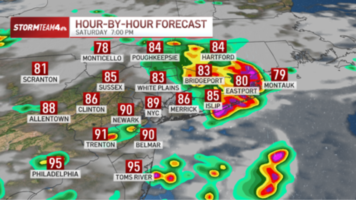
Weather patterns are expected to shift significantly following the July 4 holiday. Data from the NWS indicates that the high-pressure system responsible for the current heat will weaken by Saturday, resulting in a more temperate environment for the remainder of the weekend. High temperatures are projected to moderate to the mid-80s by Sunday, providing some relief from the current conditions, though isolated storms remain possible throughout the day.
How to Access Real-Time Weather Updates
Because weather patterns can shift rapidly, residents are encouraged to utilize official forecasting tools to receive timely information. The National Weather Service provides up-to-date radar imagery and severe weather alerts through its official website. Monitoring these resources allows for the most accurate tracking of storm cells as they develop in real time. For those in specific jurisdictions, local emergency management agencies often provide text-based alert systems that offer immediate notifications regarding severe weather warnings or changes to public event schedules.
While the forecast indicates that most of the holiday will remain dry, the risk of a passing thunderstorm remains a factor for outdoor planners. Rather than assuming a day-long rain event, participants should prepare for the possibility of a brief, intense shower. By maintaining access to live radar, attendees can better time their activities to avoid the worst of the weather. For the latest official bulletins and safety guidance, residents should consult their local National Weather Service office or state-level emergency management portal.
Looking Ahead: Weekend Outlook
The atmospheric transition beginning Saturday signifies the end of the current heat wave. According to extended forecasts, the shift to mid-80s temperatures will be accompanied by a lingering risk of isolated thunderstorms late Saturday and Sunday. This pattern is consistent with typical summer weather in the region, where humidity often fuels short-lived but intense convective activity. As the region moves into the post-holiday period, the focus for weather monitoring will shift from extreme heat management to tracking these isolated storm cells.
The next official updates regarding regional weather conditions will be released by the National Weather Service through their standard 24-hour cycle of forecasts and public advisories. Readers are encouraged to share their experiences with local weather conditions in the comments section below and stay tuned for further developments as the weekend progresses.