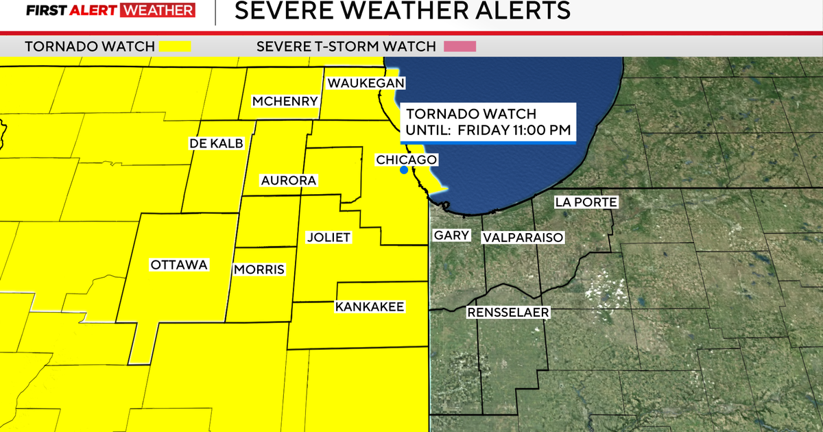
The entire Chicago metropolitan area is under a tornado watch as two rounds of severe storms move eastward from the west, according to the National Weather Service. The watch, which covers multiple counties in Illinois and Indiana, was expanded on Friday evening to include all of Chicago and surrounding areas as forecasters warned of the potential for tornadoes, large hail, damaging straight-line winds up to 70 mph, and flooding.
Reports of tornado activity have already emerged from northwestern Illinois, where a tornado was confirmed near Lena, Illinois, approximately 47 miles west of Rockford. The storm damaged both the high school and elementary school in the town even as students were still inside, prompting law enforcement to warn residents to avoid the area due to extensive structural damage. In Machesney Park, located in Winnebago County, observers reported seeing funnel clouds as the first wave of storms passed through the region.
The initial round of storms moved across northwestern Illinois but curved north before reaching Chicago, instead tracking into Wisconsin. However, a second, more potent line of storms is now approaching the Chicago area and is expected to arrive around 8 p.m. Local time. This second wave is anticipated to produce the most significant impacts, including widespread damaging winds and the continued threat of tornadoes across the entire metropolitan region.
As the storms approached, the National Weather Service issued a series of warnings across multiple counties. Tornado warnings were activated for De Kalb, La Salle, and McHenry counties until 10 p.m., and for Cook, DuPage, Grundy, Ford, Kane, Kankakee, Kendall, Lake, Iroquois, Livingston, and Will counties in Illinois, along with Benton, Jasper, Lake, Newton, and Porter counties in Indiana, until 11 p.m. Specific tornado warnings were also issued for Ford, Iroquois, and Livingston counties until 10:15 p.m., and for Grundy, Kankakee, Kendall, Livingston, and Will counties until the same time.
In addition to tornado threats, severe thunderstorm warnings were in effect for several counties. These included DuPage, Grundy, Kane, Kendall, and Will counties until 10 p.m., and Ford, Iroquois, Kankakee, Livingston, and Will counties until 10:15 p.m. Another severe thunderstorm warning was issued for Cook and Will counties until 10:45 p.m. The combination of these warnings reflects the multi-faceted danger posed by the storm system, which includes not only the potential for tornadoes but also large hail, flash flooding, and destructive straight-line winds.
The approaching storms prompted immediate safety measures across the region. A ground stop was implemented at O’Hare International Airport until 9:45 p.m. Due to thunderstorm activity, resulting in average delays exceeding three hours. Flash flood warnings were also issued for Lake, McHenry, and Boone counties, remaining in effect until 2 a.m. As heavy rainfall raised concerns about river overflow and urban flooding, particularly along the Des Plaines River and other local waterways.
Officials continue to urge residents to remain vigilant and take shelter immediately if a tornado warning is issued for their area. The safest location during a tornado is a basement or an interior room on the lowest floor of a sturdy building, away from windows. Those in mobile homes or vehicles are advised to seek shelter in a nearby permanent structure. Emergency management agencies emphasize that tornadoes can develop rapidly, often with little warning, making immediate action critical when alerts are issued.
As the storm system progresses through the region, weather monitoring remains active. The National Weather Service continues to update its alerts in real time, with the potential for additional warnings or extensions depending on storm evolution. Residents are encouraged to stay informed through official channels, including local news outlets, weather applications, and direct updates from the National Weather Service.
For the most current information on warnings, watches, and safety guidance, the public should consult the National Weather Service’s Chicago office website or enable emergency alerts on mobile devices. The situation remains dynamic, and further updates will be issued as the storms move through the area overnight.
Worth a look