
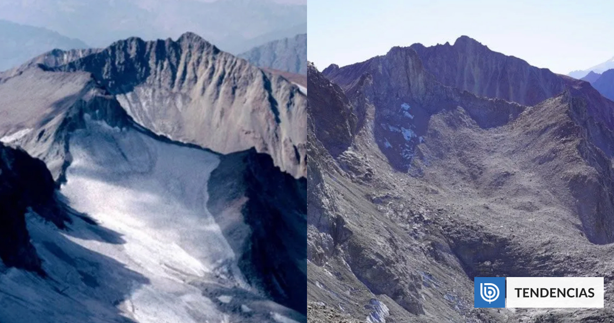
A critical environmental threshold has been crossed in the Central Andes of Chile, as a new study reveals that the Echaurren Norte Glacier has lost approximately 65% of its surface area over the last 70 years. Once a robust ice body and a cornerstone of regional hydrological stability, the glacier has now transitioned into a fragmented state, leaving it severely compromised and stripped of visible clean ice.
The findings, published on March 25, 2026, in the Annals of Glaciology, describe a devastating trajectory of degradation. The glacier has shrunk to a combined area of just 0.18 square kilometers, now existing as three separate, debris-covered units. This transformation marks the shift of the Echaurren Norte from an active mountain glacier to what researchers describe as a debris-covered glacieret
, characterized by negligible ice flow and limited basal sliding according to the study published by Cambridge University Press.
The loss is not merely a matter of surface area; We see a systemic collapse of the glacier’s physical structure. The study notes that the ice body has suffered from frontal retreat, surface thinning, and a progressive covering of supraglacial debris. Today, the glacier is essentially hidden beneath a layer of rock and sediment, which prevents the typical reflective properties of ice from protecting it from solar radiation, further accelerating its demise.
For the global scientific community, the disappearance of the Echaurren Norte is a significant loss. Along with the Zongo Glacier in Bolivia, it serves as a reference glacier for the World Glacier Monitoring Service, boasting the longest mass balance time series in the Southern Hemisphere. Its decline provides a stark, documented chronicle of how climate change and prolonged drought are erasing the “water towers” of the Andes.
A Legacy of Monitoring Amidst Decline
The historical significance of the Echaurren Norte is tied to Chile’s long-standing effort to understand its water security. Following the severe drought of 1968—the second driest year of the 20th century—Chilean authorities and water stakeholders began to recognize glaciers as vital reservoirs during exceptionally dry periods. This realization led to the creation of a formal glacier monitoring program in 1971, spurred by UNESCO’s International Hydrological Decade as detailed in the Annals of Glaciology.
By 1974, the Dirección General de Aguas (DGA), Chile’s governing body for water resources, integrated the monitoring of snow and ice hydrology into its official activities. The goal was to forecast meltwater flow for the September–March period to support the irrigation networks and water catchments that sustain the population and agriculture in Central Chile. The Echaurren Norte became a primary site for this data collection, making its current state of fragmentation a particularly poignant indicator of environmental shift.
The current research, led by James McPhee of the University of Chile, utilized satellite imagery spanning from 1955 to 2023 to quantify the loss. The data confirms a sustained loss of mass, surface area, and thickness over the last decade, with the study concluding that the glacier currently lacks the capacity to recover.
The “Water Tower” Crisis in the Cajón del Maipo
The Echaurren Norte is located in the Cajón del Maipo, a region critical for the water supply of the Santiago metropolitan area. Glaciers in this region act as natural regulators, storing water in winter and releasing it slowly during the dry summer months. When a glacier loses 65% of its surface and fragments into small, debris-covered patches, this regulatory mechanism fails.

The fragmentation of the ice body means that the “buffer” effect is gone. Instead of a steady release of meltwater, the region becomes more susceptible to the extremes of the current “megadrought” affecting Central Chile. This has sparked an urgent water alert, as the loss of glacier ice directly impacts the groundwater recharge and the flow of rivers that feed agricultural valleys.
Key Environmental Impacts of the Fragmentation
- Loss of Albedo: As clean ice is replaced by dark rock (debris), the surface absorbs more heat, accelerating the melting of the remaining ice.
- Hydrological Instability: The transition to a “glacieret” means the ice no longer flows or regenerates, leading to a permanent reduction in the volume of water available for the downstream ecosystem.
- Ecosystem Stress: The reduction in steady meltwater flow threatens high-altitude wetlands and the biodiversity that depends on glacial runoff.
What This Means for Global Glaciology
The fate of the Echaurren Norte is being viewed by experts as a “reference case” for glacier degradation in the Central Andes. Because the monitoring data is so comprehensive, scientists can use this glacier to model what will happen to other similar ice bodies in the region. The progression from a healthy glacier to a fragmented, debris-covered remnant provides a blueprint for the “vanishing glaciers” phenomenon occurring globally.
The study emphasizes that the Echaurren Norte is no longer an active glacier in the traditional sense. Its inability to maintain a positive mass balance—where snow accumulation in winter exceeds summer melt—means it is now in a state of terminal decline. This serves as a warning that many other glaciers in the Andes may be further along in this process than current satellite data suggests, especially if they are covered by debris that masks the underlying ice loss.
Timeline of Echaurren Norte’s Decline
| Period/Year | Key Event/Status | Impact/Observation |
|---|---|---|
| 1955 | Baseline Satellite Data | Glacier maintains a significant, contiguous surface area. |
| 1968 | Great Drought | Triggers official recognition of glaciers as critical water sources. |
| 1971–1974 | Monitoring Initiation | UNESCO and DGA establish formal snow and ice hydrology programs. |
| 1975–2023 | Sustained Degradation | Progressive frontal retreat and surface thinning occur. |
| 2026 (Study) | Critical Fragmentation | 65% surface loss; reduced to 0.18 km² in three debris-covered units. |
The Path Forward: Monitoring the Vanishing
While the outlook for the Echaurren Norte is bleak, the researchers argue that the site remains scientifically invaluable. The study calls for new strategies to link the historical data of the Echaurren Norte to future monitoring efforts in the region. By understanding exactly how this glacier died, scientists hope to better predict the collapse of other Andean ice bodies and develop more accurate water management strategies for the cities and farms that rely on them.
The University of Chile continues to lead these efforts, emphasizing that the “homage” to the glacier is found in the rigorous documentation of its finish. This data is essential for the World Glacier Monitoring Service to update its global models on ice loss and sea-level rise contributors.
The next critical checkpoint for regional water management will be the upcoming seasonal reports from the Dirección General de Aguas, which will assess the spring-summer meltwater flow for the current year to determine the severity of the water shortage in the Central Andes.
We invite our readers to share their thoughts on the impact of glacial melt in the comments below. How should governments prioritize water security in the face of vanishing glaciers? Share this article to spread awareness of the Andean water crisis.