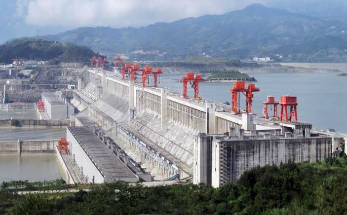
Chinese geologists have identified an active tectonic fault running directly beneath the world’s largest hydropower project in Tibet.
The discovery comes from a study conducted by researchers from Chengdu University of Technology, the Civil-Military Integration Centre of the China Geological Survey, and the Middle Yarlung Zangbo River Natural Resources Observation and Research Station. According to reporting by the South China Morning Post, the scientists found that a fracture in the Earth’s crust in the eastern Himalayan region could significantly compromise the integrity of the dam, roads, bridges, and tunnels.
The Paizhen Fault and Seismic Risk in Medog County
The project is situated in Medog County, Tibet, where the river—known in China as the Yarlung Tsangpo—makes a sharp U-turn before entering India’s Arunachal Pradesh and later Bangladesh. Geologists describe the surrounding rock formations as loose and weakly bonded, making them vulnerable to slope failures under prolonged water immersion. The Paizhen Fault has remained active since the Pleistocene epoch and continues to generate seismic activity.
Evidence of the fault’s volatility includes a magnitude 6.9 earthquake that struck its northern edge in 2017. The researchers have urged engineers to install retaining structures and reinforce vulnerable slopes to mitigate the risk of collapses.
Contradicting Beijing’s Safety Claims
Beijing has consistently dismissed external concerns, maintaining that the project is scientifically planned. In an official statement issued in December 2024, China asserted that the hydropower project was safe and prioritized ecological protection. A Chinese Foreign Ministry spokesperson further claimed in July last year that the project would help prevent disasters along the river
and would not negatively impact downstream regions.
However, the internal findings published in the journal Sedimentary Geology and Tethyan Geology suggest otherwise. The paper states that the Paizhen Fault will have a major impact on the structural stability of the reservoir area and nearby infrastructure. While the government maintains a solid foundation
for the project, its own geologists are highlighting a reality where the landscape remains in constant motion.
Financial Stakes and Energy Capacity
The scale of the project is intended to dwarf existing infrastructure. It is projected to generate more than 300 billion kWh of electricity annually, meeting the power needs of over 300 million people. The project’s capacity is estimated at 67–80 GW, which is roughly triple that of the Three Gorges Dam.
| Source | Estimated Project Cost |
|---|---|
| Mizzima | US$137 billion |
| South China Morning Post | USD 167.8 billion |
| East Asia Forum | Exceeding US$160 billion |
This massive investment is tied to Beijing’s ambitions for carbon neutrality and energy security. The project is also being integrated into the State Grid’s AI-driven smart energy brain
, turning the dam into a digital and hydrological platform.
India’s Counter-Capacity and the ‘Energy Cold War’
New Delhi views the upstream control in Tibet as strategic leverage that could be weaponized to induce floods or droughts. To counter this, India launched a US$77 billion hydropower initiative in mid-2025. This plan involves constructing more than 200 dams in its northeast, primarily in Arunachal Pradesh, with a planned capacity of 75 GW.
The centerpiece of India’s strategy is the Upper Siang Multipurpose Project, an 11 GW dam on the Siang River. Arunachal Pradesh Chief Minister Pema Khandu has described this push as a national security necessity
. The rivalry has evolved into what some describe as an energy cold war, where hydropower is linked to AI-enabled grids and data sovereignty. India is utilizing partnerships with the US and Japan to build this counter-capacity, while the US treats these clean energy investments as weights against China’s Belt and Road Initiative.
Downstream Risks for 130 Million People
The Brahmaputra basin supports nearly 130 million people across China, India, and Bangladesh who rely on the river for agriculture, fisheries, and drinking water. While China claims the project is a run-of-the-river station that will not reduce water flow, the geological instability of the Paizhen Fault introduces a different kind of risk.

The primary danger is not just water quantity but the potential for catastrophic failure. Any major disruption caused by slope failures or seismic events would not be confined to Chinese borders. The lack of a binding water-sharing treaty leaves India and Bangladesh vulnerable to the management of the reservoir, sediment transport, and emergency responses during natural disasters.
The current situation leaves a critical gap in transparency. While Chinese geologists have now flagged the structural risks, the actual ability of downstream nations to anticipate and manage sudden changes in flow remains dependent on data-sharing that has historically been unreliable.
- Did Trump just kill his own nuclear deal?
- La France propose à l’Allemagne son alternative au Patriot américain, et Berlin ne dit pas non – Forum Militaire
- DIY Project Turns Apple AirPods Into a Frisbee Tracker (archyde.com)
- Trip.com Group Fined $765 Million by Chinese Regulators for Market Monopoly (archyworldys.com)