
Meteorologists in Taiwan expect between three and five tropical cyclones to approach the island during the 2024 typhoon season, according to data released by the Central Weather Administration (CWA). Officials have indicated that the ongoing El Niño-Southern Oscillation (ENSO) cycle could increase the proportion of high-intensity storms, prompting calls for heightened public vigilance throughout the summer and autumn months.
The CWA’s seasonal outlook suggests that while the total number of storms may fall within a near-normal range, the atmospheric conditions associated with the current climatic patterns favor the development of more powerful systems. This forecast relies on historical climate data and ocean temperature monitoring, which show that El Niño events often shift the favorable areas for typhoon formation, potentially leading to more intense cyclones in the Western Pacific basin.
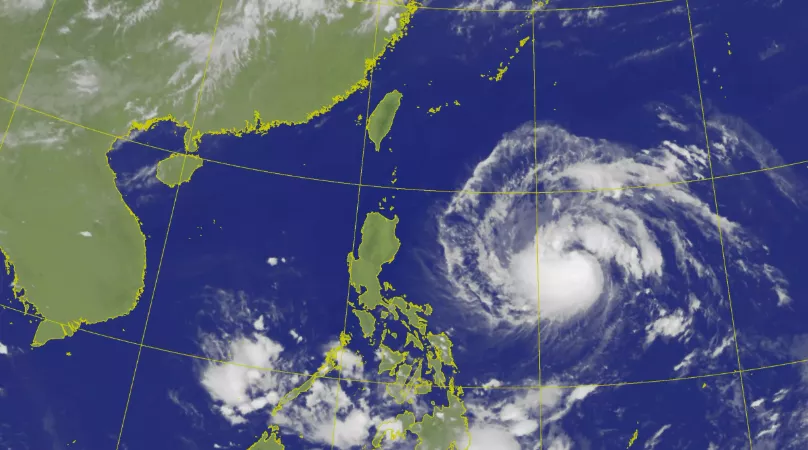
Understanding the Impact of El Niño on Typhoon Intensity
The relationship between sea surface temperatures and storm development is a primary focus for the CWA. When El Niño conditions persist, warmer-than-average ocean temperatures in the central and eastern Pacific can influence the tracks and strength of typhoons. According to the Central Weather Administration, these conditions often provide more energy for storms, increasing the likelihood that they reach “strong” or “super” typhoon status before approaching the Taiwan region.
Historically, the intensity of a typhoon is measured by its central pressure and maximum sustained wind speeds. The CWA emphasizes that even if the frequency of typhoons remains lower than in previous years, a higher proportion of “strong” storms presents a more significant risk to infrastructure and public safety. Residents are encouraged to monitor updates through the official CWA weather portal, which provides real-time warnings and tracking maps as systems develop.
Seasonal Forecasts and Public Preparedness
The CWA defines the “typhoon season” as running from June through November, with the peak frequency typically occurring between July and September. While the agency provides these estimates to assist with disaster preparedness, they note that the exact number of storms can fluctuate based on atmospheric variability that is difficult to predict months in advance. The unpredictability of these storms requires consistent monitoring of local advisories.
Emergency management agencies in Taiwan frequently conduct drills and review disaster response protocols during the pre-season period. The government’s approach to disaster risk reduction involves coordinating between the CWA, the National Fire Agency, and local municipal governments to ensure that evacuation routes, flood control systems, and emergency supplies are prepared. Official guidance for households includes maintaining an emergency kit with food, water, and essential documents, as well as securing loose outdoor items before a storm makes landfall.
Historical Context and Climate Trends
Climate scientists have observed that global warming, combined with cyclical phenomena like El Niño, can alter the behavior of tropical cyclones. While each individual storm’s path is determined by specific steering currents, the aggregate trend shows a potential for storms to maintain intensity for longer durations. According to research cited by regional meteorological bodies, the shifting of these patterns necessitates more robust long-term infrastructure planning to withstand higher wind speeds and heavier rainfall.
The CWA continues to utilize satellite imagery and numerical weather prediction models to track the development of tropical depressions. By analyzing data from the past several decades, the agency aims to refine its seasonal outlooks to better inform the public and reduce the potential for property damage and loss of life. These efforts are part of a broader commitment to climate adaptation in the face of changing meteorological trends across the Asia-Pacific region.
For the most current information, the public should rely on official bulletins issued by the Central Weather Administration. These updates are the primary source for accurate tracking, wind speed projections, and potential rainfall impact assessments. As the season progresses, the CWA will issue specific typhoon warnings if a system is deemed to pose a direct threat to the island. Readers are encouraged to check these official channels regularly and share verified safety information with their communities.