Taiwan’s Central Weather Bureau has issued heavy rain warnings for 13 counties—including New Taipei, Taoyuan, and Hsinchu—as storm systems expand northward, with three regions bracing for severe thunderstorms capable of flash flooding and localized damage. Authorities have advised residents to prepare for prolonged downpours, strong winds, and temperatures climbing toward 35°C, signaling a return to summer weather patterns.
The bureau’s latest advisory, issued June 16, marks a significant shift in weather activity after days of persistent rainfall in southern Taiwan. While central and southern regions like Yunlin, Chiayi, and Tainan experienced intense thunderstorms earlier in the week, the storm front has now intensified and moved northward, affecting areas previously less impacted. Meteorologists warn that the heaviest rainfall could persist into the evening, particularly in the northern and central regions.
According to the Central Weather Bureau, the storm system is being driven by a cold front interacting with warm, moist air from the southwest, creating unstable atmospheric conditions conducive to thunderstorm development. The bureau has classified three regions—Taichung, Changhua, and Nantou—as high-risk zones for severe thunderstorms, with the potential for lightning strikes, sudden downpours, and localized flooding.
“The storm front is moving northward more rapidly than initially forecasted, and we are seeing a concentration of moisture that could lead to heavy rainfall in areas not typically prone to such intense weather,” said a bureau spokesperson. “Residents in the northern counties should be particularly vigilant, as the combination of heavy rain and strong winds could lead to power outages and travel disruptions.”
Central Weather Bureau, June 16, 2024
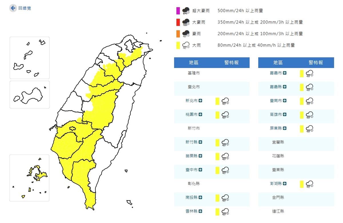
Which Counties Are Under Heavy Rain Warnings?
The Central Weather Bureau has issued heavy rain advisories for the following 13 counties and cities:
- New Taipei City
- Taoyuan
- Hsinchu
- Miaoli
- Taichung
- Changhua
- Nantou
- Yunlin
- Chiayi
- Tainan
- Kaohsiung
- Pingtung
- Hualien
Among these, Taichung, Changhua, and Nantou are under the highest alert for severe thunderstorms, with the bureau warning of potential flash flooding and strong winds. Residents in these areas are advised to avoid outdoor activities and secure loose objects that could become projectiles in high winds.
For the latest updates, the bureau recommends checking their official website or following their social media channels, where real-time alerts and radar imagery are continuously updated.
Why Is the Storm System Moving Northward?
The unexpected northward shift in the storm front can be attributed to a combination of factors, according to meteorologists. A high-pressure system over the Pacific has weakened, allowing the cold front to push farther inland than initially projected. Additionally, the interaction between the cold front and the warm, moist air flowing in from the South China Sea has intensified convection, leading to the formation of thunderstorms.
“This is a classic example of how small changes in atmospheric pressure can lead to significant shifts in weather patterns,” explained Dr. Wang Mei-ling, a meteorologist with Taiwan’s National Central University. “The models are improving, but they still struggle with predicting the exact path of these systems when multiple variables are in play.”
Historically, Taiwan experiences its most intense rainfall during the summer months, particularly between June and September, when the southwest monsoon brings heavy downpours. However, the current system is notable for its rapid movement and the breadth of regions it is affecting simultaneously.
What Precautions Should Residents Take?
With the storm system expected to persist into the evening, authorities are urging residents to take the following precautions:

- Flooding: Avoid low-lying areas and basements, which are prone to rapid flooding. Do not attempt to walk or drive through flooded roads.
- Lightning: Stay indoors and away from windows. If outside, seek shelter in a sturdy building or a vehicle with a metal roof.
- Strong Winds: Secure outdoor furniture, decorations, and trash cans. Trim tree branches that could pose a hazard.
- Power Outages: Have flashlights, batteries, and a portable phone charger on hand. Unplug electronic devices to protect them from surges.
- Travel: Delay non-essential travel, especially by air or sea, as thunderstorms can disrupt flights and ferry services.
The National Fire Agency has also deployed additional personnel to high-risk areas to respond to any emergencies, including rescues and power line repairs. Residents are encouraged to report any hazards or flooding to local authorities immediately.
How Long Will the Heavy Rain Last?
According to the Central Weather Bureau, the heavy rain is expected to persist through the evening, with the most intense activity concentrated between 3 PM and 9 PM local time. However, scattered showers could continue into the night, particularly in the northern and central regions.
Meteorologists indicate that the storm system will begin to weaken as it moves farther inland, with conditions gradually improving by midnight. By June 17, temperatures are expected to rise sharply, reaching up to 35°C in many areas, signaling the return of summer heat.
“While the rain will ease overnight, the humidity will remain high, so residents should still be cautious about heat-related illnesses,” said a bureau official. “The combination of heavy rain followed by hot, humid air can create conditions for sudden thunderstorms later in the week.”
Key Takeaways
- 13 counties under heavy rain warnings, with Taichung, Changhua, and Nantou at highest risk for severe thunderstorms.
- Storm system driven by a cold front interacting with warm, moist air, moving faster than initially forecasted.
- Heavy rain expected to persist through the evening, with risks of flash flooding and strong winds.
- Temperatures to rise sharply to 35°C by June 17, returning to summer heat.
- Authorities advise flood precautions, lightning safety, and securing outdoor hazards.
Where to Find Official Updates
For real-time weather updates and advisories, residents are directed to the following official sources:
- Central Weather Bureau – Official forecasts, radar imagery, and alerts.
- National Fire Agency – Emergency response and safety guidelines.
- Taiwan Ministry of Transportation – Travel advisories and road conditions.
- Central Weather Bureau Facebook – Real-time alerts and social media updates.
The bureau will issue updated advisories by 5 PM local time, with a full assessment of the storm’s impact expected by midnight. Residents are encouraged to monitor these channels for any changes in the forecast.
For those affected by the storms, the Central Weather Bureau recommends reporting any hazards or flooding to local disaster response teams via the emergency hotline 119.
What Happens Next?
The Central Weather Bureau will hold a press briefing at 6 PM local time to provide a detailed analysis of the storm’s movement and any adjustments to the forecast. Residents in high-risk areas are advised to remain vigilant and prepared for potential power outages or travel disruptions.
Looking ahead, meteorologists predict that the weather will stabilize by June 17, with temperatures rising and humidity increasing. However, the bureau warns that the current system could set the stage for additional thunderstorms later in the week as the atmosphere remains unstable.
We will continue to monitor the situation and provide updates as more information becomes available. In the meantime, residents are encouraged to share their experiences and any safety concerns in the comments below.
Jonathan Reed is a senior journalist and editor with over 16 years of experience covering international affairs, political developments, and breaking news. Based in London, he holds an MA in International Journalism from City, University of London, and has won multiple awards for investigative reporting, including the British Press Award for Investigative Reporting in 2022.
As Editor of the News section at World Today Journal, Jonathan leads coverage of global events, ensuring that readers receive accurate, timely, and deeply reported news.
Related reading