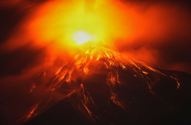
Hundreds of residents living on the southern slopes of Guatemala’s Fuego volcano were forced to evacuate their homes as a massive eruption sent towering plumes of ash and flows of incandescent lava cascading down the mountain. The sudden intensification of activity prompted emergency management authorities to raise local threat levels and deploy rescue personnel to secure vulnerable communities near the summit.
Guatemala’s National Coordinator for Disaster Reduction (CONRED) reported that the active phase began early, blanketing nearby towns in thick ash and triggering immediate safety protocols. Local emergency response teams worked alongside municipal authorities to move families out of high-risk ravines and establish temporary shelters for displaced residents.
The Volcanology, Seismology, Meteorology and Hydrology Institute (INSIVUMEH) tracked continuous seismic tremors associated with the eruption. According to scientific briefings issued by the institute, explosive activity generated pyroclastic flows—fast-moving currents of hot gas and volcanic matter—that surged down multiple drainage channels surrounding the cone.
Emergency Response and Evacuations
Civil protection units launched coordinated evacuations across several hamlets situated directly in the path of potential lahars and lava lobes. Authorities urged families to pack essential documents, secure livestock where possible, and follow designated evacuation routes away from active riverbeds.
Emergency shelters opened in safer zones further from the volcano, providing cots, clean water, and basic medical evaluations for those displaced by the sudden onset of activity. Municipal workers distributed protective face masks to mitigate respiratory risks posed by heavy ash fallout in surrounding municipalities.
Volcanic Activity and Monitoring
Volcanologists noted that Volcán de Fuego, one of Central America’s most active volcanoes, maintains a persistent state of unrest characterized by frequent minor explosions. However, the latest escalation marked a sharp increase in intensity, producing columns of ash that rose thousands of meters into the atmosphere.
Aviation authorities issued advisories for regional flight paths as upper-level winds carried the ash plume across adjacent departments. Monitoring networks continue to track gas emissions, thermal anomalies, and seismic signals to provide real-time updates to civil protection leadership.
Community Impact and Outlook
Agriculture in the fertile foothills surrounding the volcano suffered immediate disruption, with crops covered in a heavy grey layer of tephra. Farmers voiced concern over the long-term viability of coffee and vegetable plots depending on seasonal rains to wash away accumulated mineral deposits.
CONRED officials announced that red alerts remain active in zones closest to the slopes, prohibiting unauthorized access until scientific monitoring confirms a sustained reduction in seismic energy. Authorities encourage the public to monitor official channels for ongoing updates, weather forecasts regarding rain-induced mudflows, and instructions regarding eventual return phases.
We welcome your thoughts and updates on this developing situation. Please share your comments below.