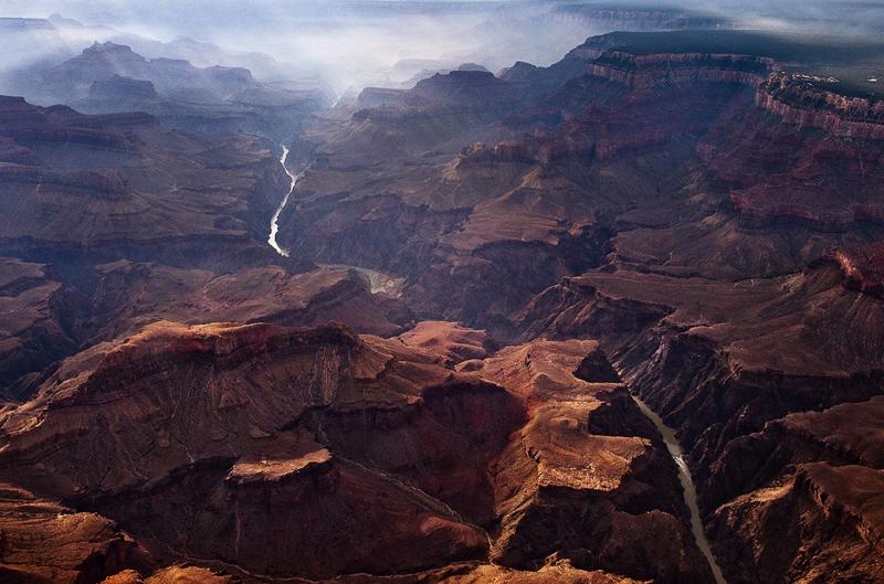
On April 16, 2026, a study published in Science presented fresh evidence supporting the long-debated theory that the Grand Canyon was formed when an ancient lake overflowed its banks and carved the iconic gorge. The research, led by geologists from the Arizona Geological Survey and collaborating institutions, analyzed mineral grains from sediment deposits in the Bidahochi Basin and downstream of the Grand Canyon. These grains, identified as durable zircon crystals, showed matching origins in the Colorado River watershed, indicating that the river once flowed into the basin before spilling westward to establish its current path through the canyon.
The findings contribute to a growing body of perform attempting to resolve one of geology’s most persistent puzzles: when and how the Grand Canyon formed. For decades, scientists have disagreed on the timeline, with estimates ranging from 5 million to 70 million years. The latest study narrows this window, proposing that the pivotal overflow event occurred approximately 6.6 million years ago. At that time, a precursor to the modern Colorado River began filling the Bidahochi Basin—a large topographical depression in northern Arizona—creating a substantial lake. As water accumulated, it eventually breached the basin’s western rim, unleashing a powerful flood that eroded the rock layers and set the stage for the canyon’s deepening.
This “spillover hypothesis” contrasts with alternative models suggesting the canyon formed primarily through gradual erosion by the Colorado River acting in place, or through a series of disconnected drainage systems that slowly integrated over time. The new zircon analysis provides concrete evidence of hydrological continuity between the river’s upper reaches and the Bidahochi Basin, strengthening the case for a sudden, catastrophic flood as the trigger for the canyon’s integration into the river’s current course.
Brian Gootee, a geologist with the Arizona Geological Survey and co-author of the study, first noticed the similarity between sand deposits in the two locations during fieldwork. The visual resemblance—both containing pink, rounded grains—prompted further investigation. By isolating and dating zircon minerals from each site, the team confirmed they shared a common source in the igneous and metamorphic rocks of the Colorado River headwaters, located in Colorado, Utah and Wyoming. This provenance match indicates that sediment transported by the river reached both the ancestral basin and the downstream canyon region, supporting the idea of a connected drainage system prior to the spillover event.
The study’s methodology relied on uranium-lead dating of zircon crystals, a technique valued for its precision in determining the age of geological materials. Zircon is highly resistant to weathering and metamorphism, making it an ideal tracer for tracking sediment origins over vast distances and timescales. The consistency in age and composition between the Bidahochi and canyon-adjacent deposits undermines earlier criticisms that the two sediment sources were unrelated—a concern raised in prior analyses where mismatches were attributed to sampling from local streams rather than the main river channel.
Whereas the 6.6-million-year-old timeline aligns with some previous estimates, it remains contested. Other research teams have proposed different mechanisms and chronologies, including the possibility of multiple stages of canyon formation or the influence of tectonic uplift in shaping the landscape. The authors acknowledge that their findings do not rule out a more complex history but argue that the spillover event represents a critical juncture in establishing the canyon’s connection to the lower Colorado River system.
Understanding the Grand Canyon’s origins has implications beyond academic curiosity. The canyon serves as a natural laboratory for studying erosion, sediment transport, and landscape evolution—processes that affect water resources, ecosystem development, and seismic hazard assessments in arid regions. Insights into how the Colorado River integrated its drainage network may also inform modern water management strategies, particularly as climate change alters precipitation patterns and increases stress on freshwater systems across the southwestern United States.
As of now, no new field campaigns or public announcements have been scheduled specifically to follow up on this study. Researchers involved indicate that ongoing work includes refining sediment transport models and exploring additional basins along the river’s path for similar provenance signals. The scientific community continues to debate the relative roles of catastrophic flooding versus gradual erosion in shaping one of the Seven Natural Wonders of the World.
For readers interested in the evolving science behind the Grand Canyon’s formation, updates are typically shared through peer-reviewed journals such as Science, Geology, and GSA Bulletin, as well as through press releases from the United States Geological Survey (USGS) and academic institutions like the University of Arizona and Arizona State University.
What do you think about the role of ancient lakes in shaping major landscapes? Share your thoughts in the comments below, and consider sharing this article with others curious about Earth’s dynamic history.