
Firefighting crews are currently engaged in a high-stakes battle to contain the Flanders Fire, a rapidly spreading wildfire in Crow Wing County, Minnesota. The blaze, which ignited amid volatile weather conditions, has forced residents to evacuate their homes as emergency responders struggle to establish a perimeter against a fire that has shown no signs of slowing.
As of the latest reports from the Minnesota Incident Command System (MICS), the Flanders Fire has grown to an estimated 600 acres. Containment remains at 0%, a critical status that indicates the fire’s edge is not yet secured by firebreaks or suppression efforts. The situation is being exacerbated by a Red Flag Warning, which signals a dangerous combination of low humidity and strong winds that facilitate the rapid movement of flames across dry terrain.
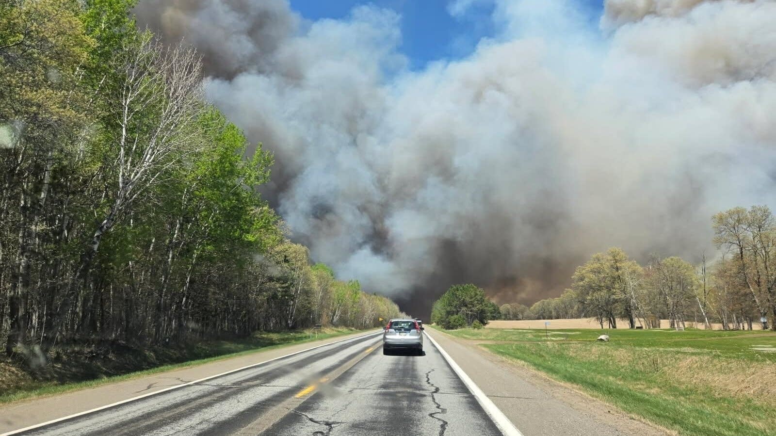
The fire is located approximately 10 miles east of Breezy Point, Minnesota, primarily impacting areas along Highway 6. The urgency of the response reflects the volatility of the environment, with multiple aircraft and ground crews deployed to prevent the fire from encroaching further into residential zones and critical infrastructure.
For residents in the affected region, the immediate priority is safety and adherence to official directives. The Crow Wing County Sheriff’s Office is currently coordinating evacuations to ensure civilians are moved out of the path of the fire. To support those displaced, the Crosslake Community Center has been opened as a designated shelter for families affected by the blaze.
Containment Challenges and Resource Deployment
The struggle to bring the Flanders Fire under control is a coordinated effort involving several state and local agencies. The Minnesota Department of Natural Resources (DNR) is leading the strategic response, working in tandem with Crow Wing County crews and multiple local fire departments. The deployment of multiple aircraft is a central component of the strategy, as aerial tankers and helicopters are used to drop water and retardants to cool the fire’s head and leisurely its advance.
The 0% containment figure is a result of the “rapid” spread attributed to the current weather patterns. In wildfire management, containment refers to the percentage of the fire’s perimeter that has been surrounded by a control line—such as a road, a river, or a manually cleared strip of land—which prevents the fire from expanding. When containment is at zero, the fire is essentially “open,” meaning it can expand in any direction driven by the wind.
Ground crews are facing significant obstacles, including the density of the vegetation and the unpredictable nature of wind shifts common during Red Flag conditions. These conditions make it hazardous for firefighters to establish anchor points, as the fire can “spot,” or jump, across control lines via airborne embers.
Evacuations and Critical Road Closures
Public safety officials have implemented strict access controls to facilitate emergency movements and protect the public. A significant disruption has occurred on the local transport network, with County Road 11 closed from Cross Lake, Minnesota, to State Highway 6. This closure is essential to keep the roadway clear for heavy firefighting equipment and to prevent civilians from entering high-risk zones.
The coordination of evacuations by the Crow Wing County Sheriff’s Office is a critical life-safety operation. In fast-moving wildfires, the window for safe evacuation can close quickly. Officials have emphasized the importance of immediate compliance with evacuation orders, as the combination of smoke and heat can make roads impassable within minutes.
The establishment of the Crosslake Community Center as a shelter provides a centralized location for displaced residents to receive updates and basic necessities. This facility serves as a hub for communication between the affected population and the agencies managing the crisis.
The Impact of Red Flag Warning Conditions
The rapid escalation of the Flanders Fire is directly linked to the Red Flag Warning issued for the region. These warnings are typically issued by weather services when critical fire weather conditions are present—specifically, a combination of high winds and very low relative humidity. When the air is dry and the wind is strong, fuel (such as dry grass, pine needles, and brush) becomes highly combustible, and any spark can lead to an explosive growth in fire size.
In the case of the Flanders Fire, these conditions have allowed the blaze to reach 600 acres in a short window of time. The “rapid” spread mentioned by the Minnesota Incident Command System underscores the difficulty of using traditional ground-based suppression techniques, as the fire often moves faster than crews can dig lines.
This weather pattern is not isolated to Crow Wing County, as several northern Minnesota counties have been under similar warnings, creating a heightened state of alert for fire managers across the state. The dryness of the soil and vegetation makes the landscape a “tinderbox,” where the risk of new ignitions is high and the ability to control existing fires is diminished.
Regional Wildfire Crisis: The Stewart Trail Fire
While the Flanders Fire is a primary concern in Crow Wing County, it is part of a broader trend of devastating wildfires currently impacting northern Minnesota. Another significant event, the Stewart Trail Fire located north of Two Harbors, has also caused substantial damage. That blaze was estimated at over 350 acres as of Saturday.

The impact of the Stewart Trail Fire has been particularly severe regarding property loss, with reports indicating that more than 30 buildings have burned. This has led to the continued closure of Highway 61 in that area, further isolating communities and complicating the logistics of the emergency response.
The simultaneous occurrence of these fires puts an immense strain on state resources. The Minnesota DNR must balance the allocation of aircraft and specialized crews between multiple active fronts, prioritizing areas where there is an immediate threat to human life and structures.
Guidance for Residents and Affected Parties
For those living in or near the Flanders Fire area, official updates are the only reliable source of information. Residents are encouraged to monitor the Crow Wing County Sheriff’s Office and the Minnesota Department of Natural Resources for real-time evacuation maps and road closure updates.
Practical safety steps for those in high-risk zones include:
- Preparing a “Go Bag”: Including essential medications, important documents, and basic supplies.
- Monitoring Air Quality: Wildfire smoke contains fine particulate matter that can be hazardous to health, particularly for those with respiratory conditions.
- Following Official Routes: Avoid using shortcuts or unverified paths, as these may be blocked by fire or reserved for emergency vehicles.
The ongoing situation remains fluid. The next critical checkpoint for the community will be the next official status update from the Minnesota Incident Command System, which will provide updated acreage and containment percentages. Residents are urged to remain vigilant and prioritize evacuation orders over property preservation.
We invite readers to share this update to help keep the community informed. Please leave your comments below or share this article on social media to ensure those in the affected areas are aware of the current closures and shelter locations.