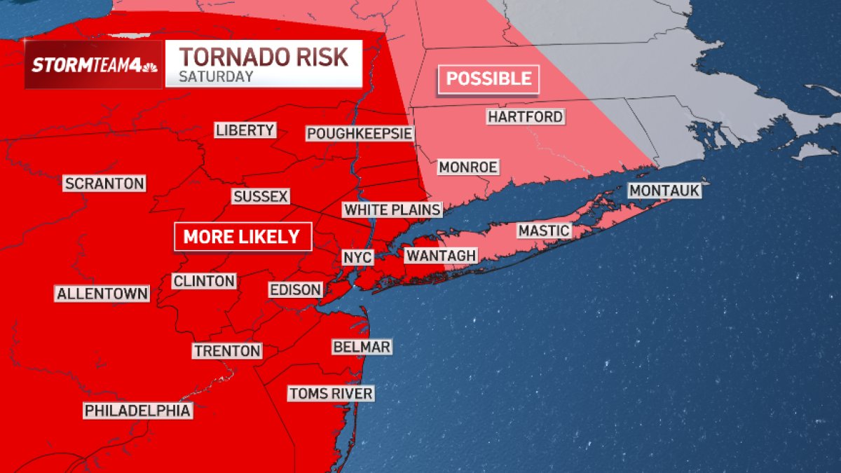
A volatile storm system is moving across the northeastern United States today, bringing an elevated risk of flash flooding, isolated tornadoes, and damaging winds to the New York City metropolitan area. The National Weather Service has placed much of the tri-state region at a Level 3 out of 5 for severe weather, signaling a significant threat to public safety from late morning through the evening hours.
When systems of this magnitude collide with high-density urban environments, the economic and logistical fallout—from supply chain disruptions to transit delays—is often as significant as the meteorological impact. Residents are advised to monitor official alerts closely as the front progresses.
Assessing the Meteorological Risks to the Tri-State
The primary hazard for the region involves intense rainfall, with projections indicating between 3 and 4 inches of precipitation, according to current National Weather Service forecasts. These totals pose a high risk for flash flooding, particularly in low-lying coastal areas and urban centers with limited drainage capacity. Beyond the water threat, the atmospheric conditions are primed for severe thunderstorms capable of producing straight-line winds and isolated tornadoes.
Meteorologists have identified a specific geographic corridor of concern. The Poconos, the Catskills, and regions across New Jersey are currently facing the highest probability of wind-related damage and tornadic activity. For those in North and Central New Jersey, as well as New York City, Long Island, and coastal Connecticut, the risk of flooding remains the most acute danger. In addition to wind and rain, the system carries the potential for hail, which can cause localized property damage.
Impact on Regional Air Quality and Upcoming Events
One notable byproduct of this vigorous storm system is its role in clearing the regional atmosphere. The storms are expected to displace the Canadian wildfire smoke that has significantly impacted air quality throughout the tri-state area over the past several days. This transition to cleaner air arrives just ahead of a shift in weather patterns, as a passing cold front is anticipated to move through the area by Sunday.
The timing of this front is relevant for major public events scheduled in New Jersey. With the storm system moving out, clearer conditions are expected to follow, potentially stabilizing the environment for large-scale outdoor gatherings. However, until the front has fully cleared the coastline, the National Weather Service cautions that the threat of rapid-onset weather changes remains in effect.
Safety Guidance and Official Monitoring
Public safety officials urge residents to remain indoors during the height of the storm and to avoid travel through flooded roadways. To stay informed, citizens should rely on direct updates from the National Weather Service and local emergency management agencies.
As the system continues to track across the Northeast, we will monitor for any changes in the severity of the storm or further official guidance regarding regional infrastructure. Please share your local observations in the comments below, and stay tuned for the next update once the cold front has fully cleared the region on Sunday.
Worth a look