
On August 21, 2018, a powerful earthquake with a magnitude of 7.3 struck off the coast of Venezuela, rattling buildings in the capital, Caracas, and sending thousands of residents into the streets. The tremor, which occurred at a depth of approximately 123 kilometers, was one of the strongest seismic events to hit the South American nation in decades, according to the United States Geological Survey (USGS). While the event caused significant alarm and structural damage to older infrastructure, no immediate fatalities were reported by government authorities in the direct aftermath.
The earthquake, centered near the coast of Sucre state, was felt across much of the country and neighboring islands, including Trinidad and Tobago. Venezuelan Interior Minister Néstor Reverol stated in a televised address that the government had activated emergency protocols to monitor potential damage, emphasizing that while the intensity was high, the depth of the rupture likely mitigated the potential for catastrophic surface destruction. The USGS recorded the magnitude at 7.3, a figure that remains the official benchmark for the event’s intensity.
Seismic Activity and Regional Impact
The 2018 earthquake occurred along a complex tectonic boundary where the Caribbean and South American plates interact. Venezuela is situated in a region prone to seismic activity, though the 7.3 magnitude event was particularly notable for its reach. According to reports from the Reuters news agency, the shaking lasted for several seconds, prompting evacuations in high-rise buildings in Caracas and causing localized power outages in several states. In areas like the capital, the swaying of structures caused panic, with many residents recalling the sensation of buildings shifting during the prolonged tremor.

The impact was not limited to Venezuela. In Trinidad and Tobago, the earthquake caused structural cracks in some buildings and temporary disruptions to utility services. The University of the West Indies Seismic Research Centre monitored the event, noting that the depth—which they calculated at 110 kilometers—was a critical factor in why the shaking was felt over such a wide geographic area without causing the level of destruction typically associated with shallower, high-magnitude quakes.
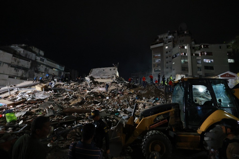
Infrastructure Vulnerability and Public Response
The response to the earthquake highlighted existing concerns regarding infrastructure maintenance in Venezuela. Many residents reported that older buildings in the center of Caracas suffered cracks and minor collapses of facade elements. Local authorities, including the Civil Protection agency, urged citizens to remain calm and to avoid re-entering buildings until safety inspections could be conducted by municipal engineers. The government’s ability to coordinate a comprehensive disaster response was scrutinized by international observers, given the ongoing economic challenges facing the country at the time.
In the aftermath, the Pan American Health Organization and other regional bodies emphasized the importance of reinforcing building codes in high-risk seismic zones. While no mass casualties were recorded, the incident served as a stark reminder of the region’s vulnerability to natural disasters. Emergency service providers in affected states, including Sucre and Miranda, were tasked with conducting rapid assessments of critical infrastructure, such as schools and hospitals, to ensure they remained operational.
Understanding Seismic Risk in the Caribbean Basin
Geologists identify the northern coast of Venezuela as a high-risk area for earthquakes due to the active fault systems running parallel to the coastline. The 2018 event followed a pattern of historic seismic activity in the region, which has experienced several significant tremors throughout the 20th and 21st centuries. Experts from the Seismological Society of America often point to this region as a primary focus for long-term disaster preparedness planning, particularly as urban density increases in coastal cities.

For residents, the event solidified the necessity of maintaining personal emergency kits and establishing communication plans with family members. Official guidance from the Venezuelan government, disseminated through the Ministry of Interior, continues to stress the importance of “drop, cover, and hold on” techniques, which are standardized protocols for minimizing injury during high-magnitude seismic events. While the 2018 earthquake concluded without a major loss of life, it remains a referenced case study for regional emergency management and the ongoing need for seismic-resistant urban planning.
Updates on regional seismic monitoring can be found via the USGS Earthquake Hazards Program, which provides real-time data on global tectonic activity. If you have questions about earthquake safety or historical data regarding this event, feel free to share your thoughts or inquiries in the comments section below.