
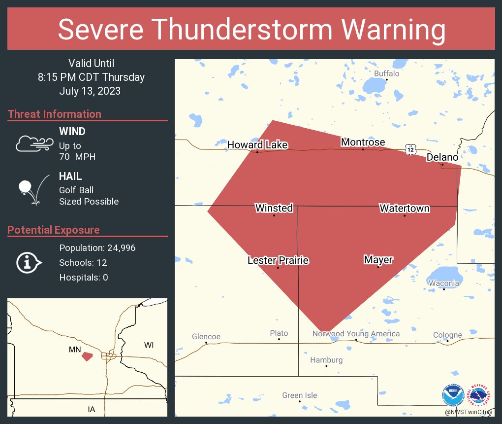
Severe thunderstorm watches have been issued for the Twin Cities metropolitan area and surrounding regions of Minnesota, with forecasters warning of potentially damaging winds up to 70 mph and the possibility of large hail, including stones described as ping pong-sized. The National Weather Service has highlighted the threat of isolated tornadoes as storms develop through Thursday afternoon and evening, urging residents to remain alert and prepared for rapidly changing conditions.
According to verified reports from local news outlets and utility providers, Xcel Energy has mobilized crews across central and southern Minnesota in anticipation of the severe weather outbreak. The utility company stated it is monitoring forecasts closely and has positioned additional personnel to respond swiftly to any power outages, prioritizing restoration efforts for the largest affected areas to return service to the maximum number of customers as quickly as possible.
Residents are being advised to seize precautionary measures ahead of the storms, including securing outdoor objects, reviewing emergency plans, and ensuring access to reliable weather alerts. Officials emphasized the dangers of downed power lines, instructing the public to assume any fallen wire is energized and to report such hazards immediately by calling Xcel Energy’s outage hotline at 1-800-895-1999 or using the company’s mobile app and outage map for real-time updates.
The weather system driving this activity is part of a broader pattern affecting the Plains and Upper Midwest, with meteorologists noting favorable atmospheric conditions for supercell development capable of producing large hail, damaging straight-line winds, and isolated tornadoes. While the exact timing and intensity of storm cells remain subject to change, the watch area covers a significant portion of central, southern, and eastern Minnesota, including the Minneapolis-St. Paul metro.
Utility Preparedness and Public Safety Guidance
Xcel Energy confirmed it maintains a diverse energy mix to support grid reliability during extreme weather events, allowing it to continue delivering power even when portions of its infrastructure are impacted by storms. The company advised customers to keep refrigerator and freezer doors closed during outages to preserve food safety, noting that a full freezer can maintain freezing temperatures for approximately two days, while a half-full freezer may last about one day under the same conditions.
In addition to reporting outages through official channels, the public can access the Xcel Energy Outage Map online, which displays the number of customers affected and provides estimated restoration times when available. The utility reiterated that safety remains the top priority, both for its crews working in the field and for residents navigating the aftermath of severe weather.
Local emergency management agencies have not issued evacuation orders at this time but are monitoring the situation in coordination with the National Weather Service. Residents are encouraged to identify safe shelter locations within their homes, such as basements or interior rooms on the lowest floor away from windows, particularly if a tornado warning is issued for their area.
Understanding the Threat: Hail, Winds, and Tornado Potential
Severe thunderstorms are classified by the National Weather Service when they produce hail at least one inch in diameter, wind gusts of 58 mph or greater, or a tornado. The current watch includes the potential for hail significantly larger than the severe threshold, with reports indicating the possibility of stones reaching ping pong size — approximately 1.5 inches in diameter — which can cause damage to vehicles, roofs, and outdoor equipment.
Wind gusts reaching 70 mph are capable of snapping tree limbs, damaging mobile homes, and creating hazardous driving conditions, especially for high-profile vehicles. Meteorologists explained that such winds often result from downdrafts within storm cores, where rain-cooled air accelerates downward and spreads outward upon hitting the ground.
While tornadoes remain less likely than hail or damaging winds in this scenario, the atmospheric setup includes sufficient wind shear and instability to support brief, isolated tornado formation, particularly along the leading edge of the storm line. The National Weather Service advises treating any thunderstorm under a watch as potentially dangerous and recommends having multiple ways to receive warnings, including NOAA Weather Radio, smartphone alerts, and local news broadcasts.
Where to Find Official Updates and Resources
For the most current information, the public is directed to the National Weather Service’s Twin Cities office website and social media channels, which provide real-time updates on watches, warnings, and storm trajectories. Local news stations including FOX 9, 5 EYEWITNESS NEWS, and MPR News are also providing continuous coverage, with meteorologists tracking storm evolution minute by minute.
Xcel Energy encourages customers to download its official mobile app for iOS and Android devices, which allows users to report outages, view restoration progress, and receive push notifications specific to their service area. The company’s website hosts a detailed outage map that is updated regularly during weather events.
As of the latest available information, no fatalities or serious injuries have been reported in connection with the developing storm system. Authorities continue to urge caution, particularly during travel, and remind drivers never to attempt to cross flooded roads or ignore barricades set up by public works crews.
The next official update from the National Weather Service is expected within the next few hours as the storm system progresses through the region. Residents should remain vigilant and prepared to take action if watches are upgraded to warnings.
Stay informed, stay safe, and share this information with others who may be affected. For ongoing coverage of severe weather events across the United States and around the world, visit World Today Journal’s News section.