x(800).jpg)
Heavy rainfall and an elevated flood risk are impacting the Gulf Coast as a low-pressure system, formerly classified as Tropical Storm Arthur, moves across the Deep South. According to the National Weather Service, the system has brought significant precipitation to parts of Louisiana and Mississippi, prompting local officials to issue flash flood watches and warnings for vulnerable areas. Residents are advised to monitor local National Hurricane Center advisories as the remnants of the storm continue to track eastward.
The system, which weakened from tropical storm status earlier this week, remains a potent source of atmospheric moisture. Forecasters at the Weather Prediction Center have identified a high risk of excessive rainfall, particularly for regions already saturated by recent storms. While the center of the system has moved inland, the lingering instability is contributing to localized severe weather, including the potential for brief, isolated tornadoes, as noted in recent Storm Prediction Center outlooks.
Regional Flood Risks and Precipitation Totals
The primary concern for the Deep South is the accumulation of rainfall in a short duration. In New Orleans and surrounding parishes, emergency management officials have activated drainage protocols to mitigate potential street flooding. According to the National Weather Service office in New Orleans, rainfall totals in some areas reached between two to four inches within a 12-hour period, with higher amounts possible in slow-moving convective bands. The risk remains acute for low-lying areas and locations with compromised drainage infrastructure.
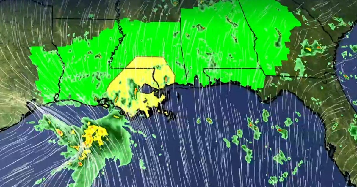
In Baton Rouge, while initial forecasts suggested heavy impacts, city officials reported that the city largely avoided the most severe rainfall totals overnight. Public works departments continue to monitor pump stations as the system transitions through the region. According to updates provided by the WAFB First Alert weather team, the threat of significant flooding persists into Thursday morning as the system interacts with a stalling frontal boundary over the Gulf Coast states.
Impact on Infrastructure and Public Safety
State and local agencies are coordinating to manage the impacts of the persistent moisture. The threat posed by the remnants of Arthur is twofold: the immediate risk of flash flooding and the secondary risk of convective storm activity. The Louisiana Governor’s Office of Homeland Security and Emergency Preparedness has encouraged residents to avoid driving through flooded roadways, citing the danger of hidden debris and rising water levels.
Meteorological data indicates that the moisture surge is being funneled into the Mississippi River Valley, creating a corridor of concern for emergency responders. For real-time updates on road conditions, residents are directed to the Louisiana Department of Transportation and Development traveler information system. Officials emphasize that even after the primary circulation of the storm dissipates, the saturated ground will likely maintain a heightened flood vulnerability for the next 24 to 48 hours.
Understanding the Atmospheric Dynamics
Why does a downgraded system still pose a significant threat? When a tropical system loses its organized structure, it does not immediately lose its moisture content. Meteorologists explain that the latent heat and high precipitable water values associated with tropical remnants can fuel localized flooding even without the high-sustained winds characteristic of a storm’s peak intensity. According to the National Oceanic and Atmospheric Administration, these events are common in the Gulf Coast region during the transition between spring and summer, where warm Gulf waters provide the necessary fuel for continued convective development.

The current setup is further complicated by a stationary boundary, which acts as a focus point for rainfall. This interaction frequently leads to training—a meteorological term where multiple storms track over the same geographic location in succession. This phenomenon is why some communities see minor impacts while nearby towns experience significant flash flooding. Residents should rely on official National Weather Service alerts rather than generalized social media reports to determine the risk level for their specific zip code.
The next official update regarding the system’s dissipation and the expiration of flood watches is expected to be issued by the National Weather Service on Thursday afternoon. Please share this information with neighbors in affected areas and check back for further updates as the situation evolves.
Related reading