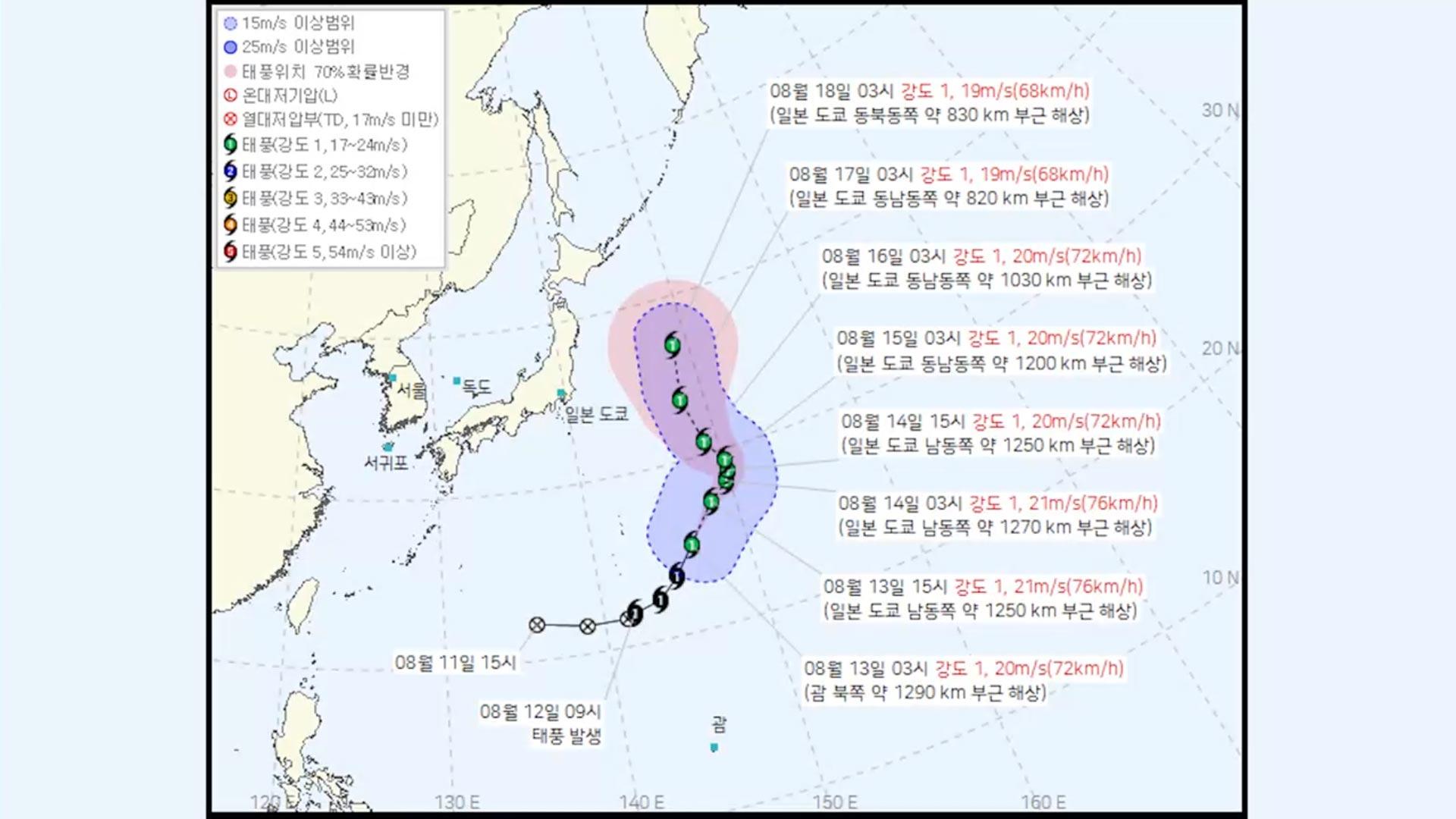
As Typhoon Nangka tracks northwestward across waters southeast of Tokyo, regional weather authorities are closely monitoring the system following the passage of Typhoon Chan-hom. According to meteorological reports, Typhoon Nangka developed over open waters approximately 970 kilometers northwest of Guam, originating around 9 a.m. on the 12th of this month.
The storm system currently maintains Category 1 strength, characterized by sustained central winds of 20 meters per second. Forecasters tracking the system note that Nangka is moving in a northeasterly direction toward the maritime regions southeast of the Japanese capital. The storm’s trajectory places it on a path that poses ongoing monitoring requirements for maritime and coastal areas in the path of the system.
Meteorological projections indicate that Nangka will maintain its current intensity classification as it progresses. By early next week, forecasters expect the system to reach a position approximately 820 kilometers east of Tokyo while retaining its Category 1 strength parameters. Official naming conventions place the storm’s origin with Malaysia, which contributed the designation “Nangka,” referring to a common tropical fruit variety.
Tracking Typhoon Nangka’s Path Toward Japan
The formation of Typhoon Nangka follows closely on the heels of Typhoon Chan-hom, which previously tracked across parts of Japan. Regional weather agencies maintain active tracking protocols as Nangka advances across the Western Pacific. The system’s current movement brings it into waters monitored closely by regional forecasting networks, ensuring real-time updates for shipping lanes and coastal communities.
Data from tracking centers show the storm maintaining steady wind speeds while navigating northeastward. Authorities emphasize that while the storm holds a Category 1 designation, changing oceanic and atmospheric conditions require continuous observation. Shipping advisories and marine forecasts remain active across the affected sectors of the Western Pacific as the system progresses.
Official Advisories and Next Steps
Official meteorological offices continue to issue regular updates regarding the position, speed, and intensity forecasts for Typhoon Nangka. Mariners, coastal residents, and commercial operators in the region are advised to monitor official bulletins from national meteorological agencies for the most current data on the storm’s progression.
The next scheduled meteorological update from regional tracking centers will provide further analysis on Nangka’s exact coordinates and any shifts in intensity as it approaches the designated position east of Tokyo early next week. Readers are encouraged to share this report or leave comments below for ongoing updates regarding regional weather events.