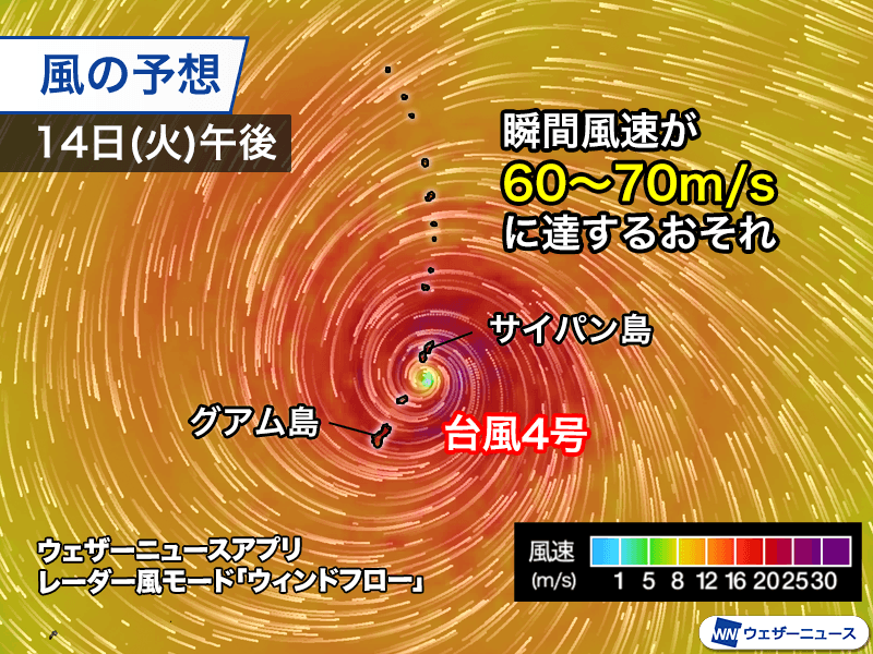
A powerful storm system is currently threatening the Mariana Islands, as Typhoon Shinrako—designated as Typhoon No. 4—intensifies into a violent force. The storm is expected to make its closest approach to Guam and Saipan on Tuesday, April 14, bringing the risk of catastrophic winds and torrential rainfall to the region.
As of 9:00 a.m. On Monday, April 13, the typhoon exhibited extreme strength, with maximum sustained winds near the center reaching 60 meters per second (m/s) and maximum gusts peaking at 85m/s according to meteorological data. The system is characterized by a massive wind field spanning 1,100 kilometers in diameter, which has already begun to envelop the Mariana Islands.
Local authorities have issued urgent warnings to residents as the storm’s trajectory suggests it will pass directly over or just south of Saipan. The most critical danger arrives Tuesday afternoon, when the “eye wall”—the area of the storm containing the most destructive winds—is projected to hit Saipan. In this scenario, instantaneous wind gusts could reach between 60 and 70m/s as reported by regional weather monitoring.
The immediate impact is already being felt across the islands. On Monday morning, Saipan recorded wind gusts of 20m/s, even as Guam observed gusts of 15m/s. These figures are expected to rise sharply as the center of the storm draws closer.
Extreme Winds and Heavy Rainfall Expected
Beyond the threat of wind, Typhoon Shinrako is carrying an immense amount of moisture. Active rain clouds on the outer bands of the storm have already begun to move over the islands, and precipitation is expected to intensify rapidly. Computer simulations indicate that total rainfall in the vicinity of the Mariana Islands could reach between 400mm and 500mm based on current meteorological modeling.
The combination of storm surges, extreme gusts, and heavy rainfall has led officials to warn of potential large-scale disasters. Residents are being urged to secure property and seek shelter immediately to avoid the most dangerous periods of the storm’s passage.
The Anatomy of a Rare April Storm
The occurrence of such a powerful typhoon in April is statistically uncommon. The name “Shinrako,” provided by Micronesia, translates to “legendary goddess” according to official naming records. This year has seen an unusual pattern of activity, with at least one typhoon forming every month since January—a trend not seen since 2015, marking an 11-year interval.
Historically, typhoons hitting the region this early in the year are rare. For context, only one recorded typhoon has made landfall in Japan during the month of April, which occurred on April 25, 1956, when Typhoon No. 3 struck Kagoshima Prefecture per historical climate data.
Potential Long-Term Path and Regional Risks
While the immediate focus remains on the Mariana Islands from April 13 through April 15, meteorologists are monitoring the storm’s northwest trajectory. The specific path of Typhoon Shinrako after Thursday, April 16, has not yet been officially announced.
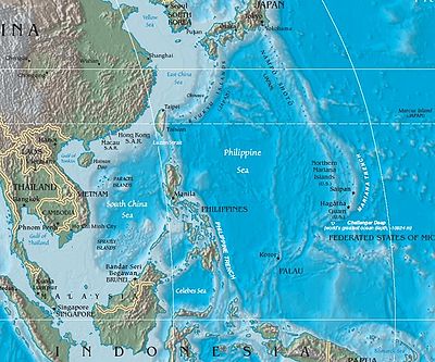
However, experts suggest the storm may lose intensity if it continues to move north. This is due to the relatively cool sea surface temperatures south of Japan, which are currently ranging between 21 and 24 degrees Celsius according to oceanographic reports. While a direct hit on Japan is less likely given these temperatures, the typhoon could still indirectly influence weather patterns across the Japanese archipelago.
Key Storm Statistics
| Metric | Value |
|---|---|
| Maximum Sustained Wind | 60 m/s |
| Maximum Gusts | 85 m/s |
| Wind Field Diameter | 1,100 km |
| Projected Rainfall (Mariana Islands) | 400–500 mm |
| Expected Peak Impact Date | April 14, 2026 |
The situation remains fluid as the storm continues to move. The next critical update regarding the typhoon’s trajectory and intensity is expected after April 16, once the system clears the immediate vicinity of the Mariana Islands.
We will continue to monitor this developing story. Please share this report to keep others informed, and leave your comments below if you are in the affected region.
Worth a look