Late-April Snowstorm Forecast for Eastern Canada: What to Expect
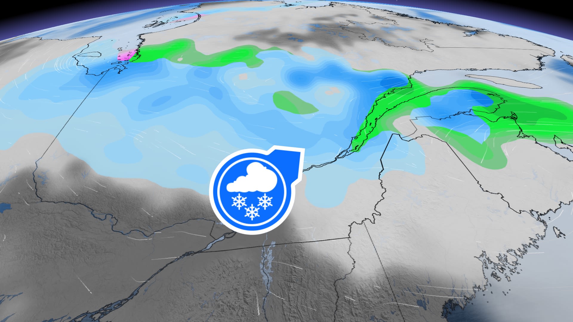
As Eastern Canada braces for an unseasonal weather event, meteorologists are warning of a late-April snowstorm set to sweep across Quebec and parts of Atlantic Canada from Thursday through Saturday. The system, which follows an unusually warm spell that brought temperatures more than 10°C above seasonal averages, threatens to disrupt travel, strain infrastructure, and challenge residents unaccustomed to winter conditions this late in the season. Forecasters say the storm could dump significant snowfall in regions where spring had already taken hold, including the scenic Charlevoix area northeast of Quebec City, which has seen a surge in tourism and remote workers in recent years.
The storm arrives as communities in Quebec and Newfoundland and Labrador are still grappling with the aftermath of a volatile winter. In Charlevoix, where heavy rain was already expected to begin Thursday, the sudden shift to snow could create hazardous conditions on roads and hiking trails in the region’s mountainous terrain. Meanwhile, in Newfoundland and Labrador, residents are being warned that winter “has not yet said its last word,” with snow and freezing rain possible in some areas even as temperatures begin to climb elsewhere in the country.
Meteorologists emphasize that the storm’s exact track and intensity remain uncertain, but preparations are underway for what could be one of the latest significant snow events in recent memory for parts of Eastern Canada. Officials are urging residents to monitor local advisories and take precautions, particularly in higher-elevation areas where snow accumulation could be heaviest.
Storm Timeline and Expected Impact
The snowstorm is expected to develop in two phases, beginning with a mix of rain and snow in southern Quebec on Thursday before transitioning to more widespread snowfall by Friday. According to MétéoMédia, the system will intensify as it moves eastward, bringing the heaviest snowfall to regions north of the St. Lawrence River, including Charlevoix, the Laurentians, and parts of the Gaspé Peninsula. By Saturday, the storm is forecast to weaken, but not before leaving a blanket of snow in areas where trees have already begun to bud—a combination that could lead to broken branches and power outages.

In Charlevoix, where local media have already warned of heavy rain beginning Thursday, the transition to snow could be abrupt. The region’s rugged topography, which includes some of the highest peaks east of the Rockies, makes it particularly vulnerable to rapid weather shifts. The Parc national des Hautes-Gorges-de-la-Rivière-Malbaie, a popular destination for hikers and nature enthusiasts, could see significant snow accumulation, creating dangerous conditions for those unprepared for winter weather.
Further east, Newfoundland and Labrador are also under winter weather advisories, with Environment Canada warning of snow, freezing rain, and strong winds in some areas. The storm’s timing is particularly challenging for the province, which has seen a series of late-winter storms this year. In St. John’s, where residents have already endured one of the snowiest winters on record, the latest system could add to the strain on snow-clearing operations and public transit.
Who Is Most at Risk?
The late-season storm poses risks for several groups, including:
- Travelers: Roads in affected areas could become slippery and hazardous, particularly in higher-elevation regions like Charlevoix and the Laurentians. The Quebec Ministry of Transport has advised motorists to check road conditions before heading out and to carry emergency kits in their vehicles. Air travel could also be disrupted, with delays possible at airports in Quebec City, Montreal, and St. John’s.
- Outdoor Enthusiasts: Hikers, campers, and skiers in popular destinations like Charlevoix’s national parks may face dangerous conditions, including reduced visibility, icy trails, and the risk of avalanches in mountainous areas. Parks Canada has urged visitors to check trail conditions and avoid backcountry areas if snow accumulates rapidly.
- Farmers and Gardeners: The sudden return of winter could damage early blooms and tender vegetation, particularly in regions where temperatures had already risen above freezing. Farmers in Quebec’s agricultural heartland are being advised to take precautions to protect crops and livestock.
- Remote Workers and New Residents: Charlevoix has seen an influx of remote workers and new residents in recent years, drawn by its natural beauty and cultural attractions. Many of these newcomers may be unfamiliar with the region’s volatile spring weather, which can swing from summer-like warmth to winter storms in a matter of days. Local officials are reminding residents to ensure they have adequate heating supplies and emergency provisions.
Why Is This Happening So Late in the Season?
While late-April snow is not unheard of in Eastern Canada, meteorologists say the timing and intensity of this storm are unusual. The system is being driven by a clash between a lingering mass of Arctic air and a warm, moist air mass moving up from the southern United States. As these two systems collide, the result is a potent storm capable of producing heavy precipitation in the form of both rain and snow.
Climate scientists note that such extreme weather swings are becoming more common as global temperatures rise. A report from Environment and Climate Change Canada found that while overall snowfall amounts have decreased in many parts of the country, the frequency of intense, late-season storms has increased. This trend is particularly pronounced in Eastern Canada, where the interaction between cold Arctic air and warmer Atlantic waters can create volatile weather patterns.
For residents of Charlevoix, where the local economy relies heavily on tourism and outdoor recreation, the storm could have mixed effects. While heavy snow may disrupt hiking and cycling trails, it could also extend the ski season at nearby resorts like Le Massif de Charlevoix, which typically closes in mid-April. The resort has not yet announced any changes to its schedule, but officials say they are monitoring the situation closely.
How to Stay Safe and Informed
With the storm’s path still uncertain, officials are urging residents and visitors to take the following precautions:
- Monitor Local Advisories: Environment Canada and local meteorological services are providing regular updates on the storm’s progression. Residents can check the latest forecasts on the Government of Canada’s weather website or through local news outlets.
- Prepare for Power Outages: Heavy, wet snow can weigh down power lines and tree branches, leading to outages. Residents are advised to have flashlights, batteries, and non-perishable food on hand. Those who rely on electric heating should consider alternative sources of warmth.
- Limit Travel: If possible, avoid unnecessary travel during the storm, particularly in rural and mountainous areas. If you must drive, ensure your vehicle is equipped with winter tires, an emergency kit, and a full tank of gas.
- Protect Property: Clear gutters and drains to prevent ice dams and flooding. If you have outdoor plants or early blooms, consider covering them to protect against frost damage.
For those in Charlevoix, local authorities are also advising residents to be cautious near rivers and streams, which could swell rapidly if rain transitions to snow. The region’s steep terrain increases the risk of flash flooding and landslides, particularly in areas where the ground is already saturated from recent rainfall.
What Happens Next?
Meteorologists say the storm is expected to weaken by Sunday, with temperatures rising and snow transitioning to rain in most areas. However, the cleanup effort could take days, particularly in regions where heavy snow accumulates. In Newfoundland and Labrador, where winter storms have already stretched resources thin, the latest system could further delay spring road maintenance and infrastructure repairs.
For now, residents are being urged to stay vigilant and prepare for what could be a messy finish to April. The next official update from Environment Canada is expected by 5:00 PM local time on Wednesday, with more detailed forecasts likely as the storm’s path becomes clearer.
As Eastern Canada braces for this unseasonal weather event, one thing is certain: winter’s final act is far from over. Whether you’re a longtime resident or a newcomer to the region, staying informed and prepared will be key to weathering the storm safely.
Have you experienced late-season snowstorms in your area? Share your stories and tips in the comments below, and don’t forget to share this article with friends and family who may be affected.
Keep reading