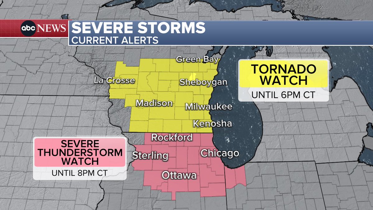
Wisconsin residents are bracing for another round of severe weather as thunderstorms, potential tornadoes, and flooding threats loom across the state this weekend. The National Weather Service has issued multiple alerts, including tornado watches and severe thunderstorm warnings, particularly for southeastern Wisconsin and the Milwaukee metropolitan area. With Easter weekend travel underway, officials urge caution as heavy rain, damaging winds, and isolated tornadoes remain possible through Saturday night.
The current weather pattern stems from a strong low-pressure system moving through the Midwest, drawing warm, moist air northward and creating unstable conditions conducive to severe storms. Radar imagery shows clusters of thunderstorms developing over Illinois and Iowa, expected to push into Wisconsin later today, and overnight. These storms could produce wind gusts exceeding 60 mph, large hail, and brief tornadoes, especially in areas south and east of Madison and Milwaukee.
In response to the heightened threat, the National Weather Service office in Sullivan, Wisconsin has issued a tornado watch effective until 2 a.m. CDT for parts of southeastern Wisconsin, including Milwaukee, Waukesha, Racine, and Kenosha counties. This watch indicates that conditions are favorable for tornado formation, though not all storms will produce one. Residents are advised to stay alert, have multiple ways to receive warnings, and identify safe shelter locations in advance.
Simultaneously, severe thunderstorm warnings are active for several Wisconsin counties, including Dodge, Jefferson, and Walworth, where storms have already demonstrated rotation and produced damaging winds. The NWS emphasizes that even without a tornado, straight-line winds from severe thunderstorms can cause significant damage to trees, power lines, and lightweight structures. Flooding concerns are also rising due to saturated soils from recent rainfall, with flash flood warnings possible in low-lying areas and near rivers.
Milwaukee Journal Sentinel reporters note that the city’s emergency management team has increased staffing at its operations center and is coordinating with local utilities and first responders. Public works crews are pre-positioning equipment to address potential downed trees and flooded roads. Meanwhile, Milwaukee County Transit System has contingency plans in place to suspend or reroute bus services if conditions become unsafe.
Weather radar from AccuWeather and the National Weather Service shows ongoing convection along a boundary stretching from Madison to Green Bay, with the strongest cells expected to affect the I-94 corridor between Milwaukee and Chicago. Storm motion is predominantly northeast at 30 to 40 mph, meaning communities ahead of the line should prepare for sudden changes in conditions. Lightning frequency is high, increasing risks for outdoor activities and travel.
Looking ahead, forecasts indicate that the primary threat will diminish after sunrise on Sunday as the system moves east and stabilizes. However, residual showers and isolated thunderstorms may persist into Monday, particularly in northern Wisconsin. No additional tornado watches or severe weather warnings are currently anticipated for the coming week, though spring variability means residents should remain prepared for rapid changes.
For real-time updates, the National Weather Service website (weather.gov) provides interactive radar, watch/warning maps, and detailed forecasts by county. Local news outlets including WTMJ-TV, WISN-TV, and FOX6 News Milwaukee offer continuous coverage during active weather events. The Ready Wisconsin campaign also maintains preparedness resources at ready.wisconsin.gov, including emergency kit checklists and shelter location guidance.
As always during severe weather seasons, officials stress the importance of having a NOAA Weather Radio or smartphone alerts enabled, knowing the difference between a watch and a warning, and avoiding travel during active warnings. With Easter gatherings planned across the state, many are adjusting indoor plans as a precaution.
Stay tuned to World Today Journal for continuing coverage of this developing weather situation and its impact on communities across Wisconsin and the Upper Midwest.
Worth a look