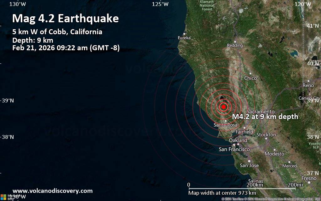
Santa Rosa, California – A moderate earthquake with a preliminary magnitude of 4.2 struck 27 miles north of Santa Rosa, California, at 9:22 am local time on Saturday, February 21, 2026. The United States Geological Survey (USGS) reported the quake occurred at a depth of 9.00 kilometers (5.6 miles), and although initial reports suggest limited damage, the event was felt across a wide area of Northern California.
The USGS, the primary agency monitoring seismic activity in the United States, initially reported the quake and continues to refine its data. The event underscores the seismic activity inherent to California, a state situated along major fault lines. This particular tremor occurred in a region west of the Salton Sea, an area of ongoing geological study, as detailed in a recent preliminary geologic map of the Southern Santa Rosa Mountains and Borrego Badlands published by the USGS in 2023. That map, available as Open-File Report 2023-1076, highlights the complex tectonic landscape of the region.
Earthquake Details and Felt Reports
According to the USGS event page (USGS Event Page), the epicenter of the earthquake was located at 38.82°N latitude and 122.79°W longitude. The shallow depth of the quake likely contributed to it being widely felt. Preliminary reports indicate light shaking was experienced in Cobb, a community located just 3 miles from the epicenter, with a population of approximately 1,800 residents.
Weak shaking was also reported in Clearlake (population 15,200), situated 13 miles from the epicenter, and Windsor (population 27,500), located 19 miles away. Residents in Santa Rosa (population 178,100), 27 miles from the epicenter, likely experienced very weak shaking. Other towns and cities where the quake may have been felt include Ukiah (population 15,900), Rohnert Park (population 42,400), Agua Caliente (population 27,100), Petaluma (population 60,400), and Napa (population 80,400). These population figures are estimates based on the most recently available data.
California’s Seismic Landscape
California is one of the most seismically active regions in the United States, due to its location along the boundary between the Pacific and North American tectonic plates. The state experiences thousands of earthquakes each year, most of which are minor and go unnoticed. However, larger earthquakes, like the one experienced today, can cause significant damage and disruption. The California Geological Survey (California Geological Survey) plays a crucial role in monitoring seismic activity and providing information to the public about earthquake hazards.
The region surrounding the Santa Rosa Mountains and Borrego Badlands, specifically, is a complex geological area. As outlined in the USGS’s 2023 report, the area features a well-exposed sequence of late Cenozoic sedimentary rocks and a tectonic boundary separating sedimentary strata from underlying crystalline rocks. This geological setting contributes to the region’s susceptibility to seismic activity. Understanding the geological framework, as detailed in the USGS’s Open-File Report 2023-1076, is vital for assessing earthquake risks and developing mitigation strategies.
Potential Impacts and Safety Measures
While a magnitude 4.2 earthquake is not typically considered to cause widespread, major damage, it can still result in localized impacts. These may include objects falling from shelves, broken windows, and minor structural damage to older or poorly constructed buildings. The USGS advises individuals to “Drop, Cover, and Hold On” during an earthquake – dropping to the ground, taking cover under a sturdy piece of furniture, and holding on until the shaking stops.
Residents are encouraged to report their experiences through the USGS “Did You Feel It?” website, which helps seismologists gather data and refine their understanding of earthquake impacts. Several mobile applications, including those offered by Volcanoes & Earthquakes (available for Android and iOS), provide real-time earthquake alerts and information.
Looking Ahead
Seismologists will continue to monitor the region for aftershocks, which are smaller earthquakes that often follow a larger event. The USGS will continue to refine its data regarding the magnitude, epicenter, and depth of the initial quake. Residents are advised to stay informed about earthquake preparedness and safety measures. The next update from the USGS regarding this event is expected within the next 24 hours as further data analysis is completed.
This event serves as a reminder of the ever-present seismic risk in California and the importance of preparedness. Further research into the geological complexities of the region, as highlighted by the USGS’s ongoing studies, will be crucial for mitigating future earthquake hazards.
We encourage readers to share their experiences and report any damage they may have observed in the comments below. Please also share this article with your networks to help spread awareness about earthquake preparedness.
Related reading