
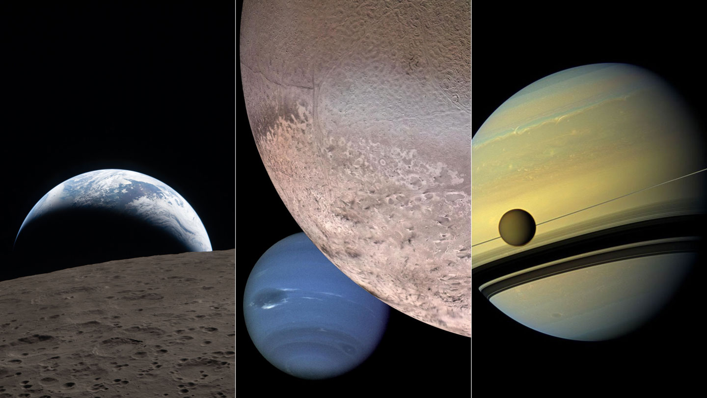
As a physician, I have spent my career understanding a fundamental truth of diagnostics: a laboratory report can tell you what is happening inside a patient, but an image—a scan, an X-ray, or a biopsy slide—tells you where it is happening and how it is unfolding. In medicine, the image provides the essential context that transforms raw data into a diagnosis. This same principle governs the exploration of our solar system, where the importance of space imagery serves as the bridge between abstract measurements and genuine discovery.
For decades, the pursuit of planetary science was often a battle of instruments. Engineers and scientists prioritized spectrometers, magnetometers, and radiometers—tools that provide precise numerical values about chemical compositions and magnetic fields. While these instruments are indispensable, they offer a fragmented view of a distant world. The push to center cameras in mission planning was not merely about taking “pretty pictures”; it was about ensuring that the scientific community had the visual context necessary to interpret every other piece of data returning to Earth.
This philosophy was championed by planetary scientist Candice Hansen-Koharcheck, whose career at the Planetary Science Institute underscored the belief that cameras belong at the core of every expedition. By advocating for the primacy of visual records, she helped shift the paradigm of space exploration, ensuring that future generations of researchers inherit a cumulative, visual archive of the cosmos rather than just columns of figures.
Beyond the Numbers: The Philosophy of Visual Science
To understand why imagery is critical, one must understand the limitation of non-visual data. A spectrometer can identify the presence of iron oxide on a Martian plain, providing a precise chemical signature. However, it cannot tell a scientist if that iron oxide is arranged in a ripple, a jagged cliff, or a smooth basin. Without a photograph, the “what” remains divorced from the “where.”

Visual records provide what scientists call “contextual evidence.” When a camera captures the surface texture of a moon or the swirling patterns of a gas giant’s atmosphere, it allows researchers to form hypotheses that numerical data alone could never trigger. A single image can reveal an unexpected geological feature—a strange ridge or a sudden color shift—that prompts scientists to re-examine their spectrometer readings with fresh questions. In this way, imagery does not just supplement the data; it directs the science.
This approach transforms the way we conduct remote sensing. By treating the camera as a primary science instrument rather than an optional add-on, mission planners create a permanent record. While a sensor’s reading is a snapshot in time, a high-resolution image is a map that can be revisited decades later as new theories emerge and new analytical tools are developed.
The Legacy of Candice Hansen-Koharcheck
Candice Hansen-Koharcheck’s contribution to the field was rooted in the insistence that seeing is a prerequisite for understanding. In the early stages of mission planning, cameras were often viewed by engineers as secondary tools—useful for navigation or public relations, but less “scientific” than a mass spectrometer. Hansen-Koharcheck challenged this hierarchy, arguing that imagery strengthens the entire mission by providing immediate verification of a probe’s environment.
Her legacy is embedded in the very pixels that now populate our understanding of the solar system. By pushing for robust imaging capabilities, she helped ensure that the data arriving from distant probes is grounded in physical reality. Her work emphasized that the human eye, aided by advanced optics, is one of the most powerful pattern-recognition tools in existence. When a scientist looks at a photograph of a planetary surface, they are not just seeing a picture; they are performing a complex analysis of morphology, lighting, and scale.
This commitment to the visual has had a profound impact on how planetary science is communicated. The images we see from NASA missions are not just for the public; they are the primary documents of discovery. They allow the global scientific community to peer-review findings in a way that raw data tables cannot facilitate, democratizing the process of discovery by making the evidence visible to all.
From Data Points to Landscapes: How Imagery Changes Discovery
The transition from “measuring” to “seeing” has fundamentally altered the trajectory of several key missions. In the exploration of Mars, for example, the use of high-resolution imaging has allowed scientists to identify ancient riverbeds and sedimentary layers that strongly suggest a watery past. While chemical analysis confirmed the presence of hydrated minerals, it was the visual evidence of fluvial morphology—the actual shapes of the land—that provided the “smoking gun” for liquid water.
This synergy between visual and numerical data is essential for the search for biosignatures. If a probe detects an organic molecule, the first question scientists ask is: “What does the surrounding environment look like?” Is the molecule located in a dried-up lakebed, a volcanic vent, or a frozen wasteland? The answer depends entirely on the quality of the imagery available. Without the visual context, a chemical detection is a curiosity; with the image, it becomes a potential discovery of life.
the archival nature of space photography means that “dead” missions continue to produce new science. Images taken by the Voyager probes decades ago are still being analyzed today using modern AI and image-processing software, revealing details that were invisible to the researchers of the 1970s. This longevity is a direct result of the priority placed on capturing high-quality visual records.
The Future of Planetary Vision
As we look toward the next frontier—the icy moons of Jupiter and Saturn, such as Europa and Enceladus—the role of the camera is more critical than ever. These worlds are shrouded in ice and darkness, requiring sophisticated imaging systems that can penetrate surface layers or capture low-light environments. The goal is no longer just to map the surface, but to visualize the interfaces where ice meets ocean, searching for the plumes of water that might harbor life.
Modern mission planning now integrates “multi-modal” sensing, where cameras are synchronized with other instruments to create a 3D, chemically mapped version of a celestial body. This evolution is the direct descendant of the philosophy championed by scientists like Hansen-Koharcheck. We are moving from a period of “blind sampling” to an era of “informed exploration,” where we can see a target of interest and decide, in real-time or near-real-time, where to deploy our most sensitive instruments.
For those interested in following the latest visual discoveries from our solar system, the NASA Science portal provides updated galleries and data from active missions, illustrating the ongoing power of space imagery to reshape our understanding of the universe.
Key Takeaways: The Power of Space Imagery
- Contextualization: Visual records transform raw numerical data from spectrometers and magnetometers into actionable scientific insights by providing the “where” and “how.”
- Permanent Archives: Unlike transient sensor readings, high-resolution images create a permanent record that can be re-analyzed as new technology and theories emerge.
- Public Engagement: Imagery bridges the gap between complex planetary science and public understanding, making distant worlds feel tangible and “home-like.”
- Mission Efficiency: Visual verification allows mission planners to confirm a probe’s environment immediately, reducing risk and optimizing the use of other science instruments.
- Scientific Legacy: The advocacy of scientists like Candice Hansen-Koharcheck shifted cameras from “secondary” tools to core scientific instruments.
The next major milestone in planetary vision will be the continued deployment of advanced telescopes and the next generation of planetary orbiters, which aim to capture imagery at unprecedented resolutions. These missions will continue to prove that in the vast, silent expanse of space, the most valuable tool we can carry is the ability to see.
World Today Journal encourages readers to share their thoughts on the intersection of science and art in space exploration. Do you believe visual evidence is more persuasive than numerical data? Join the conversation in the comments below.