Geologists have identified a massive, fan-shaped sedimentary structure hidden beneath three kilometers of ice in East Antarctica, providing new evidence regarding the tectonic breakup of the ancient supercontinent Gondwana. The discovery, detailed in research published in the journal Geology, reveals a complex drainage system that predates the formation of the current Antarctic ice sheet, offering a clearer timeline for how the continent shifted approximately 150 million years ago.
This geological formation, spanning hundreds of kilometers, was mapped using satellite imagery and radar data, which allowed researchers to peer through the thick ice cover. According to the British Antarctic Survey (BAS), which maintains extensive geophysical datasets for the region, identifying these subglacial features is essential for understanding how the Earth’s crust responded to the rifting of the supercontinent. The structure appears to be a delta or “fan” of sediment deposited by a large river system that flowed toward the ocean before the region was encased in ice.
Understanding the Gondwana Breakup
The breakup of Gondwana—a supercontinent that included modern-day South America, Africa, Antarctica, India, and Australia—was a process that spanned tens of millions of years. Scientists have long sought to understand the specific mechanical triggers that caused the landmass to fragment. The newly identified fan-shaped structure acts as a “geological scar,” reflecting the rapid subsidence of the crust as the tectonic plates began to pull apart.

As noted in findings published by the United States Geological Survey (USGS), tectonic rifting creates distinct sedimentary basins. The fan structure discovered in East Antarctica indicates that the area experienced significant vertical movement, or “rift-flank uplift,” which is a hallmark of the early stages of continental separation. By analyzing the shape and composition of these deposits, researchers can infer the direction of ancient water flow and the rate at which the crust thinned during the Jurassic period.
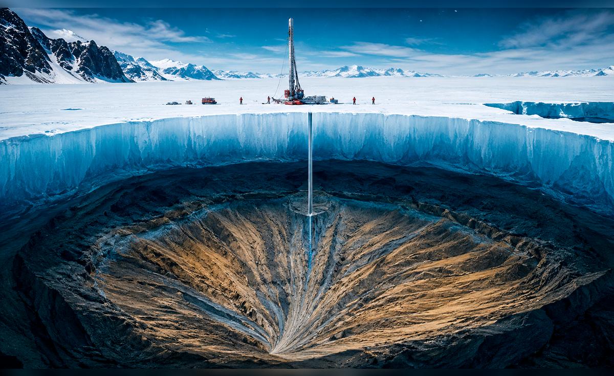
The Role of Radar and Satellite Technology
Mapping the Antarctic interior remains one of the most challenging tasks in modern geoscience. Because the ice sheet is several kilometers thick in many areas, traditional optical surveying is impossible. Instead, researchers rely on airborne radio-echo sounding, a technique that sends radar pulses through the ice to detect variations in the underlying bedrock. The Norwegian Polar Institute has been instrumental in coordinating these multi-national surveys, which provide the high-resolution data necessary to visualize these ancient landscapes.

This specific structure was detected by analyzing variations in the topography of the bedrock, which showed a distinct, wide-angle dispersion pattern characteristic of sediment transport. Unlike the rugged, mountainous terrain found in other parts of the continent, this region shows evidence of a low-lying basin that once hosted a massive, active drainage network. This discovery confirms that before the climate cooled and the ice sheet expanded, East Antarctica was a dynamic environment with significant erosion and sediment movement.
Why This Discovery Matters for Future Research
The presence of this fan-shaped structure forces a re-evaluation of existing tectonic models for the Southern Hemisphere. Previous maps of the Antarctic bedrock were based on sparser data, leading to assumptions about the continent’s stability that may now need to be updated. Understanding the history of these tectonic processes is not merely an academic exercise; it provides critical context for how the Earth’s climate and surface features have evolved over geological time.
Furthermore, the data collected from this region serves as a baseline for current glaciological studies. According to the Scientific Committee on Antarctic Research (SCAR), knowing the shape of the bedrock is vital for predicting how the modern ice sheet flows and reacts to warming temperatures. The smoother, sediment-filled basins identified in this study may influence the speed at which ice streams move toward the coast, a factor that is central to current models of sea-level rise.
Key Geological Insights
- Structure Type: Large-scale sedimentary fan, suggesting an ancient fluvial drainage system.
- Tectonic Context: Linked to the rifting of Gondwana approximately 150 million years ago.
- Detection Method: Airborne radio-echo sounding and satellite-based gravity mapping.
- Geographic Scope: Located in the East Antarctic region, preserved beneath 3 km of glacial ice.
Next Steps in Antarctic Exploration
Geologists are now focused on integrating this new data into global tectonic reconstructions. The next phase of research will involve localized ground-based seismic surveys to determine the depth and composition of the sediment layers within the fan. These field operations are typically scheduled during the austral summer months, when weather conditions permit safe deployment of equipment, according to updates provided by the National Science Foundation’s Office of Polar Programs.

As researchers continue to synthesize these findings, the scientific community expects a more comprehensive understanding of how the Antarctic landmass transitioned from a temperate, river-dominated landscape to the frozen wilderness observed today. For more information on ongoing polar research and upcoming expeditions, readers can follow official updates from the British Antarctic Survey data portal.
We welcome your thoughts on this discovery. Please share your perspectives or questions in the comments section below.
Keep reading