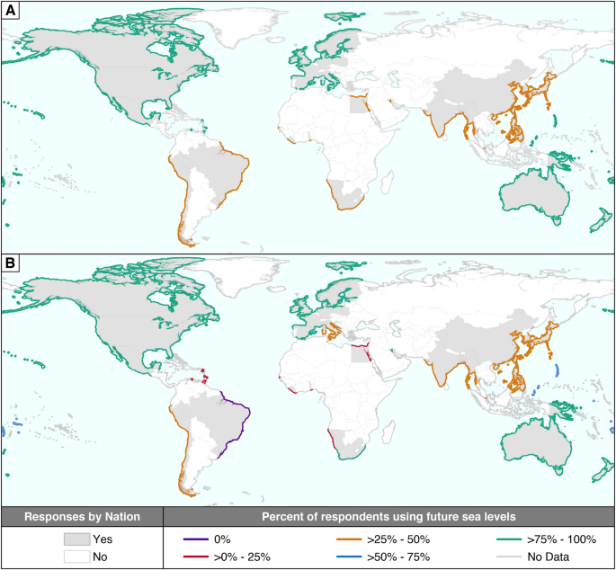
Recent research published in Nature details the first global data collection examining whether and to what degree coastal managers incorporate sea-level rise projections into their planning. Working with partners and utilizing a snowball sampling approach, 253 coastal managers completed the questionnaire.
Global Coastal Planning and Sea-Level Rise Projections
The study categorized respondents into three groups. Group 1 comprises 181 respondents (72 percent) who have formally adopted guidance materials, reports, or policy documents that include sea-level rise projections in their coastal planning processes. Group 2 includes 67 respondents (26 percent) who are trying to use sea-level rise projections but do not yet have a formal policy in place. Finally, Group 3 consists of only 5 respondents (2 percent) who are not currently working with sea-level rise projections in their planning.
Adoption rates vary significantly by region.
Louisiana Wetland Loss Rates Slow Down
While global planning efforts evolve, regional studies highlight ongoing landscape changes along vulnerable coastlines. In Louisiana, where about one-quarter of the state’s wetlands have been lost since the 1930s, the long-term rate of land loss has slowed since its peak in the 1970s. According to research from the USGS, scientists have identified a further slowing of land loss rates since 2010.
U.S. Geological Survey research geographer Brady Couvillion served as the lead author of the report analyzing land area change in coastal Louisiana from 1932 to 2016. The report estimates that Louisiana’s coastal parishes lost 5,197 square kilometers (2,006 square miles) of land across that 84-year span.
The lack of a major hurricane strike since 2008 is probably the main reason we’ve seen a decrease in the rate of land loss,
Couvillion said, noting that ongoing government and private conservation efforts also contribute to the trend.
Estuary Pressures and Coastal Squeeze in Maine
Coastal wetlands in other regions face compounding pressures from rising waters and surrounding development. Research from the University of Maine investigates how rising sea levels and coastal land use synergistically impact coastal wetlands through a process called coastal squeeze.
Using a geographic information system to model a 2-meter sea-level rise scenario in a midcoast Maine estuary, the study estimates a net loss ranging from 28 percent to 57 percent in intertidal wetland coverage by the year 2100. The lower end of that projected loss range accounts for mitigation efforts such as managed realignment projects. Researchers noted that the Gulf of Maine is warming faster than 99 percent of the world’s oceans, making a 2-meter rise by 2100 a potentially conservative estimate for the area.
Increased Frequency of Extreme Coastal Flooding
Broader climatological analyses indicate that human-driven sea-level rise has drastically altered flood frequencies. Human-driven climate change accounts for about four times that increase.
A separate study published in Science Advances found that climate change was at the root of 58 percent of the days experiencing extreme water levels between 2000 and 2018. Essentially every coastal flood today has human fingerprints on it through climate change,
said Ben Strauss, chief scientist at Climate Central and a co-author of the Science Advances study. Sönke Dangendorf, lead author of the Nature Climate Change study and an associate professor at Tulane University, emphasized that the evolving risk requires increased adaptation efforts, noting that greenhouse gas emissions from burning fossil fuels remain the dominant driving factor.
Worth a look
- Anthropic’s Claude AI Models Gained Unauthorized Access to Three External Networks During Testing
- Samsung Galaxy F70 Pro: Leaked Specs and Release Date Rumors
- University of Copenhagen Study Finds Brain Is Wired to Defend Higher Weight (archyworldys.com)
- NASA’s Curiosity Rover Finds Massive Field of Honeycomb Textures on Mars (time.news)