A late-season cold snap is poised to grip parts of Europe, particularly Italy, bringing temperatures 4-5 degrees Celsius below the seasonal average. The shift comes after a brief respite of milder weather, and is being driven by a confluence of meteorological factors, including a Balkan vortex and the influence of a low-pressure system dubbed “Jolina.” Although much of central and northern Italy is expected to remain relatively stable, the Adriatic coast and southern regions are bracing for the most significant impact, with potential for snowfall at lower elevations.
The developing situation highlights the often-unpredictable nature of European weather patterns, and the potential for rapid shifts even during the transition to spring. Forecasters are closely monitoring the movement of cold air originating in the Balkans, which is expected to intensify the cooling trend starting mid-week. This isn’t simply a localized event; it’s a demonstration of how regional weather systems can quickly impact larger areas, bringing winter-like conditions back into the forecast.
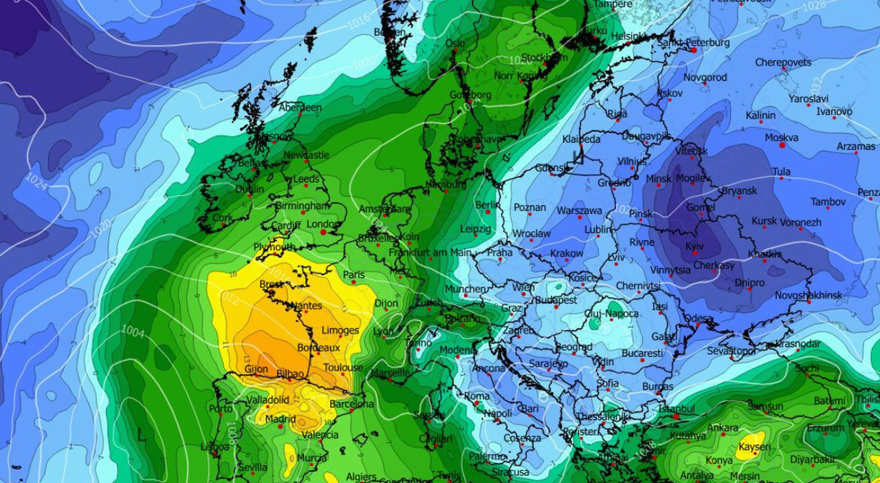
Balkan Vortex and the Return of Cold Air
Meteorological models indicate a “Balkan vortex” is the primary driver of the impending cold spell. This weather phenomenon, characterized by a swirling mass of cold air, typically forms over the Balkans and can extend its influence across Southern and Central Europe. According to 3B Meteo, a leading Italian weather forecasting service, the vortex will bring a significant drop in temperatures, particularly along the Adriatic Sea. Il Fatto Vesuviano reports that the cooling will be most pronounced on the Adriatic side of Italy, with the possibility of snow falling as low as the hills in central regions.
The term “vortex” in meteorology doesn’t refer to a single, defined structure like a hurricane. Instead, it describes a broad area of cyclonic circulation – air rotating around a low-pressure center. These vortices can be dynamic and shift position, making precise forecasting challenging. The current Balkan vortex is drawing cold air from continental Europe, exacerbating the cooling effect across Italy.
Vortice Jolina’s Impact on Southern Italy
Adding to the complexity, the low-pressure system “Jolina,” currently situated west of Sardinia, is contributing to the unsettled weather in Southern Italy. Corriere Adriatico details that Jolina is moving towards the Strait of Sicily and then into the Libyan Sea, continuing to bring adverse weather conditions to the southern regions. The areas facing the Ionian Sea are particularly vulnerable, with forecasts predicting rainfall exceeding 200 millimeters in some locations between Monday and Tuesday. Strong winds, with gusts up to 80 kilometers per hour, are also expected.
The name “Jolina” is assigned by meteorologists to identify and track specific weather systems. While not a formal designation like a hurricane’s name, it helps in communication and analysis. The system’s trajectory and intensity are being closely monitored to provide accurate warnings to affected communities. The combination of Jolina’s moisture and the incoming cold air from the Balkans creates a potentially hazardous situation, increasing the risk of flooding and strong winds.
Regional Variations in Weather Conditions
While the south and Adriatic regions are expected to bear the brunt of the cold snap, central and northern Italy are anticipated to experience more stable conditions. Reports indicate that instability will be limited to the central Adriatic regions. However, even these areas could see localized showers and cooler temperatures. This regional variation underscores the importance of localized weather forecasts and preparedness measures.
The Adriatic Sea itself plays a significant role in moderating temperatures along the Italian coast. However, the influx of cold air from the Balkans is expected to overcome this moderating effect, leading to a noticeable drop in temperatures even in coastal areas. The Adriatic Sea’s unique geography and currents contribute to its complex weather patterns, making it particularly susceptible to shifts in regional weather systems.
Looking Ahead: A Potential Second Wave of Cold
The cold spell isn’t expected to be a one-off event. Forecasters are warning of a potential second wave of cold air arriving around Wednesday and Thursday. This is linked to the closing of a high-pressure bridge over Central Europe, creating a blocking pattern that prevents warmer air from moving in from the Atlantic and Russia. This blocking pattern could trap the cold air over Italy, prolonging the chilly conditions.
A “blocking pattern” in meteorology refers to a persistent high-pressure system that disrupts the normal flow of weather systems. These patterns can lead to prolonged periods of stable weather, but they can also cause extreme conditions, such as heatwaves or cold snaps. The current blocking pattern over Central Europe is expected to reinforce the cold air mass over Italy, potentially leading to further temperature drops and increased snowfall.
The Adriatic Sea: A Region of Complex Interactions
The Adriatic Sea region is a complex interplay of geographical, political, and environmental factors. As highlighted by Osservatorio Balcani Caucaso Transeuropa, the economic disparity between the Italian Adriatic regions and the Balkan countries is significant. This economic difference reflects broader regional challenges and the ongoing development needs of the Balkan states. The Adriatic Sea serves as a crucial transportation route and a shared resource for the countries bordering it, making regional cooperation essential for sustainable development and environmental protection.
The Adriatic Sea’s unique characteristics – its relatively shallow depth, narrow width, and connection to both the Mediterranean and the Black Sea – contribute to its complex hydrodynamics and ecological sensitivity. These factors make the region particularly vulnerable to climate change and pollution, requiring coordinated efforts to address these challenges.
Preparing for the Cold Snap
Authorities are advising residents in affected areas to take precautions against the cold weather. This includes dressing warmly in layers, protecting exposed skin, and ensuring adequate heating in homes. Drivers are urged to exercise caution on the roads, as icy conditions are possible, especially in hilly areas. Local emergency services are on standby to respond to any weather-related incidents.
It’s crucial to stay informed about the latest weather forecasts and heed any warnings issued by local authorities. Checking official sources for updates is essential, as conditions can change rapidly. Preparing for potential power outages and having a supply of essential items on hand can also help mitigate the impact of the cold snap.
Key Takeaways:
- A Balkan vortex is driving a cold air mass towards Italy, lowering temperatures by 4-5°C below the seasonal average.
- Southern Italy is facing the most significant impact, with heavy rainfall and strong winds associated with the “Jolina” low-pressure system.
- Snowfall is possible at lower elevations in central Adriatic regions.
- A second wave of cold air is expected mid-week due to a blocking pattern over Central Europe.
The situation remains dynamic, and further updates will be provided as the weather system evolves. Residents are encouraged to monitor local news and weather reports for the latest information. The next official update from 3B Meteo is scheduled for Tuesday morning, providing a more detailed forecast for the coming days. Share your thoughts and experiences in the comments below.
Keep reading