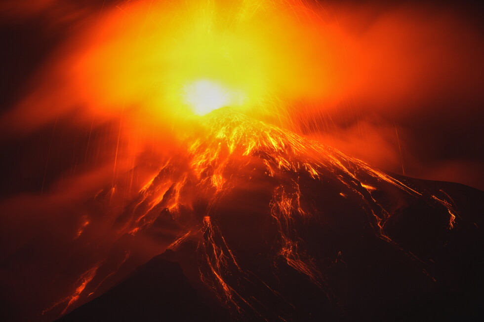
Guatemala remained on high alert as officials evacuated hundreds of residents following an intense eruptive phase at the Fuego volcano on August 4, 2026. The active volcano sent pyroclastic flows down its slopes and prompted emergency shelter operations across Sacatepéquez, Escuintla, and Chimaltenango.
Guatemalan authorities raised alert levels and rushed to protect vulnerable populations on Tuesday following a dramatic intensification of the Fuego volcano, one of Central America’s most active peaks. The surge in activity triggered preventive evacuations, road closures, and the suspension of classes across nearby towns as emergency crews monitored fast-moving hazards.
Intensifying Explosive Phase and Pyroclastic Flows
Live images broadcast from the region captured clouds of gas and ash billowing into the atmosphere, accompanied by lava and fast-moving pyroclastic flows cascading down the mountain’s ravines.

The country’s Seismology, Vulcanology, Weather and Water Institute documented an escalation in volcanic vigor. In a public press release, institute officials stated that The eruption increases its explosiveness level. A fountain of lava of between 200 and 300 metres (650ft to 1,000ft) has developed over the crater,
throwing incandescent material across the edifice.
Disaster management officials noted that the resulting pyroclastic flows—fast-moving mixtures of volcanic gas, ash, and rock—descended rapidly through five distinct ravines on the volcano’s slopes. Authorities declared an orange alert on Tuesday, stepping up monitoring as experts warned that ash cloud dispersal could impact regions stretching up to 100 kilometers (62 miles) west and northwest of the crater.
Emergency Evacuations and Shelter Operations
Local emergency teams moved to secure residents living in the immediate path of potential danger. CONRED executive secretary Claudinne Ogaldes confirmed that 659 people were evacuated from eight villages in the danger zone.
The initial phase focused on the hamlets of El Porvenir and Las Lajitas within the municipality of San Juan Alotenango, where roughly 50 families totaling about 250 people were moved to safety as a preventive measure. By Tuesday, the total population housed in temporary shelters reached approximately 1,700 people, with officials indicating these accommodations will remain operational until conditions improve according to CONRED.
Regional Impact, Closures, and Weather Risks
The crisis prompted an institutional response across the affected departments. Authorities elevated the official alert level to red specifically in Sacatepéquez, Escuintla, and Chimaltenango, where roughly 29,000 people confronted ashfall.

The Education Ministry intervened by suspending classes in neighboring towns, while transport authorities closed National Route 14, a major thoroughfare passing close to the volcano due to falling debris and visibility concerns. CONRED issued public safety advisories urging residents living throughout the three high-alert municipalities to cover their domestic water deposits and wear protective face masks against ash particles.
Emergency coordinators emphasized that the upcoming 72 hours remain a critical window as mudflows measuring up to 7 kilometers (4.3 miles) long continue descending from the volcano. Incoming rain is expected to increase the risk of additional volcanic mudflows, though officials confirmed that mudflows had not yet reached villages or damaged local structures.
Historical Context and Regional Vulnerability
The current emergency recalls past disasters associated with the peak. Located approximately 30 kilometers (19 miles) south of Guatemala City along the Pacific Ring of Fire, Fuego has a history of eruptions.
Authorities and local communities remain sensitive to the memory of June 2018, when an eruption buried an entire village and killed more than 200 people, impacting up to 1.7 million individuals. A subsequent eruption in June of last year also necessitated preventive community evacuations before conditions stabilized.
With shelters holding displaced families and rainfall threatening to spawn fresh mudflows, disaster management personnel continue checks across Sacatepéquez, Escuintla, and Chimaltenango while monitoring the crater’s ongoing output.
Worth a look