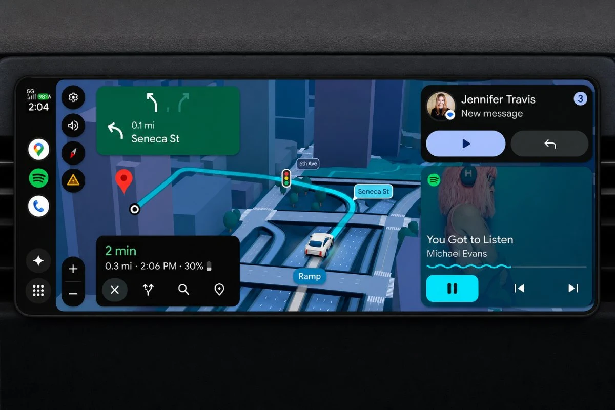
Google has begun integrating 3D building visualization into Google Maps for Android Auto, leveraging artificial intelligence to provide drivers with a more detailed, immersive navigation experience. While this update aims to improve spatial awareness on the road, the feature is currently limited to users in the United States, leaving international drivers waiting for a global rollout.
This deployment follows a broader effort by Google to standardize its visual language across platforms. By utilizing the same 3D rendering engine found in the mobile version of Google Maps, the company is attempting to bridge the gap between handheld navigation and the dashboard experience. According to official company documentation, the 3D layer is designed to help drivers better identify landmarks and building structures, potentially reducing the cognitive load required to orient oneself in dense urban environments.
How 3D Maps Function in the Vehicle
The 3D functionality on Android Auto operates by rendering building footprints and heights in real-time as a vehicle moves. This is not merely a static image; it is a dynamic, interactive map layer that adjusts its perspective based on the vehicle’s position. The integration relies on Google’s massive database of geospatial data, which the company has been refining through its Street View and satellite imagery programs for nearly two decades.

For many users, the transition to a 3D interface represents a shift from traditional “top-down” navigation to a perspective that more closely mimics human vision. However, the performance of this feature depends heavily on the processing power of the vehicle’s infotainment system. Unlike a modern smartphone, which features high-end mobile processors, many automotive head units run on older hardware. Consequently, the smoothness of the 3D rendering can vary significantly between car manufacturers and model years.
Geographic Restrictions and Deployment
Despite the technological appeal, the rollout remains restricted to the United States. Google has not provided a firm timeline for when this 3D interface will be available to users in Europe, Asia, or other regions. Industry analysts suggest that this phased approach is standard for Google, as the company often prioritizes markets where it has the most comprehensive high-definition mapping data available for building structures.

The requirement for high-fidelity 3D data is significant. To render buildings accurately, Google must have precise elevation and geometric data for entire city blocks. In regions where municipal data is less accessible or where urban architecture is more complex, the company may need additional time to verify and integrate its datasets before enabling the feature. Drivers looking to check if the update has reached their region can monitor the official Android Auto Help Center, which acts as the primary repository for feature availability and release notes.
Balancing Innovation and Driver Safety
The introduction of complex 3D graphics into a driving environment raises questions about driver distraction. Google has maintained that its interface designs are subjected to rigorous testing to ensure they comply with automotive safety standards, such as those defined by the National Highway Traffic Safety Administration (NHTSA). The goal is to provide enough information to aid navigation without overwhelming the driver with unnecessary visual noise.
In practice, the 3D layer is intended to be subtle. It is meant to assist in identifying specific intersections or large buildings that serve as waypoints, rather than acting as a distraction. For users who find the 3D view cluttered, Google typically provides an option within the navigation settings to revert to a standard 2D view. This flexibility remains a core component of the Android Auto user experience, allowing for personalization based on individual driving conditions and preferences.
What Comes Next for Android Auto
As Google continues to integrate its Gemini AI models into its suite of products, it is likely that the intelligence behind navigation will become more predictive rather than just visual. Current efforts are focused on stabilizing the 3D rendering across a fragmented ecosystem of car hardware. The next major checkpoint for users will be the subsequent version updates of the Google Maps app via the Google Play Store, which will contain the necessary patches for wider device compatibility.

For those outside the United States, there is currently no verified date for an international release. Users are encouraged to keep their applications updated and watch for official announcements from Google’s product blog. If you have experienced the 3D map update or have questions about how it performs on your specific vehicle, feel free to share your observations in the comments below.
Keep reading