
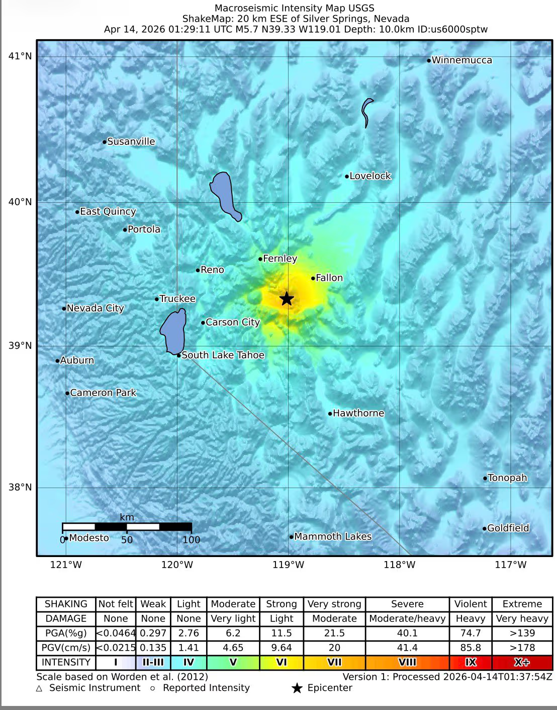
A strong Nevada earthquake measuring 5.7 in magnitude struck the western portion of the state on Tuesday, April 14, 2026, sending tremors through several urban centers and rural communities. The United States Geological Survey (USGS) confirmed the quake’s intensity, noting that the event was felt widely across the region, including in the city of Reno.
The epicenter was pinpointed approximately 20 kilometers east-southeast of Silver Springs, Nevada, according to preliminary data verified by seismic monitoring. Due to the fact that the tremor occurred at a relatively shallow depth of roughly 9 to 10 kilometers, the shaking was more pronounced for residents on the surface, increasing the likelihood of the event being felt over a broader geographic area.
Although the quake was strong enough to cause noticeable shaking in nearby urban centers, official assessments are currently underway to determine the full extent of any impact. As of Tuesday afternoon, there have been no confirmed reports of major structural damage or casualties from reporting authorities, though officials continue to monitor the situation.
Tremors Felt in Reno and Surrounding Regions
Residents across western Nevada reported brief but distinct tremors. In Reno, buildings experienced light shaking, and many locals described the sensation as a sudden, jarring movement. The shallow nature of the 5.7 magnitude quake meant that the energy released was not absorbed by the earth’s crust before reaching the surface, which typically results in more intense shaking for those near the epicenter.

Local authorities have cautioned that aftershocks are common following a seismic event of this magnitude. While aftershocks are generally weaker than the initial quake, they can still cause concern or exacerbate existing structural weaknesses in older buildings. Residents are encouraged to remain vigilant and follow local safety protocols.
Understanding Nevada’s Seismic Profile
Nevada is one of the most seismically active states in the U.S., a fact driven by its unique geological positioning within the Basin and Range Province. This region is characterized by tectonic stretching, where the earth’s crust is being pulled apart, leading to frequent fault movement and regular low-to-moderate magnitude earthquakes as detailed in the region’s seismic profile.
Seismologists classify earthquakes in the 5.0 to 5.9 range as “moderate.” While these events are rarely catastrophic on a regional scale, they are capable of causing localized damage, particularly in areas with non-reinforced masonry or near the epicenter. The specific mechanics of the Basin and Range Province mean that Nevada often experiences “swarms” or frequent moderate events rather than the massive, singular ruptures seen along the San Andreas Fault in California.
Why Depth Matters in Seismic Impact
The depth of an earthquake is a critical factor in determining how much damage occurs at the surface. A “shallow” earthquake, such as this one at 9–10 kilometers, allows seismic waves to reach the surface with more energy intact. In contrast, deeper earthquakes often result in shaking that is felt over a wider area but with less intensity at any single point, as the energy dissipates as it travels upward through the crust.
Broader Regional Seismic Activity
This event in Nevada is part of a broader pattern of seismic activity currently affecting the Western United States. In a separate event, a quake struck California, which was initially reported at a 5.1 magnitude before being revised to 4.9 by the USGS per updated data. That tremor was felt in several areas, including San Jose.
The proximity of these events highlights the ongoing volatility of the North American Plate’s western edge. While the Nevada quake and the California event occurred on different fault systems, they serve as a reminder of the necessity for stringent building codes and emergency preparedness in the American West.
Key Takeaways: The Silver Springs Earthquake
- Magnitude: 5.7 (Confirmed by USGS).
- Epicenter: Approximately 20 km east-southeast of Silver Springs, Nevada.
- Depth: 9–10 kilometers (Shallow).
- Primary Impact: Noticeable shaking in Reno and western Nevada; no major casualties or structural damage confirmed.
- Geological Cause: Tectonic stretching within the Basin and Range Province.
Authorities continue to conduct assessments of infrastructure and residential areas near Silver Springs to ensure there are no hidden hazards resulting from the tremor. The next official update from seismic monitoring agencies is expected as they analyze the full wave-form data to determine the exact fault line involved in the rupture.
World Today Journal encourages readers to share this report and abandon their comments below regarding any local impacts experienced during the event.