Back-to-Back Winter Storms Threaten Millions Across Northern US
A late-season surge of winter weather is poised to disrupt millions across the Northern Plains, Upper Midwest, and New England, bringing heavy snow, strong winds, and potentially blizzard conditions. After a brief respite of warmer temperatures, residents are bracing for two consecutive storm systems expected to arrive within days of each other. The National Weather Service has issued a series of warnings and advisories, urging caution and preparation as the storms approach. The first system is already impacting areas of the Rockies and Plains, even as a second, more potent storm is gathering strength in the Pacific Northwest.
The impending weather events represent a significant shift from the unseasonably mild conditions experienced recently. Forecasters warn that the combination of heavy snowfall and high winds could create dangerous travel conditions, lead to power outages, and disrupt daily life for a large portion of the population. The storms are expected to impact major metropolitan areas, including Minneapolis, Green Bay, and Marquette, as well as more rural communities throughout the affected regions. The potential for significant snowfall accumulations, exceeding two feet in some areas, is raising concerns among emergency management officials.
First Storm Brings Gusts and Whiteout Conditions
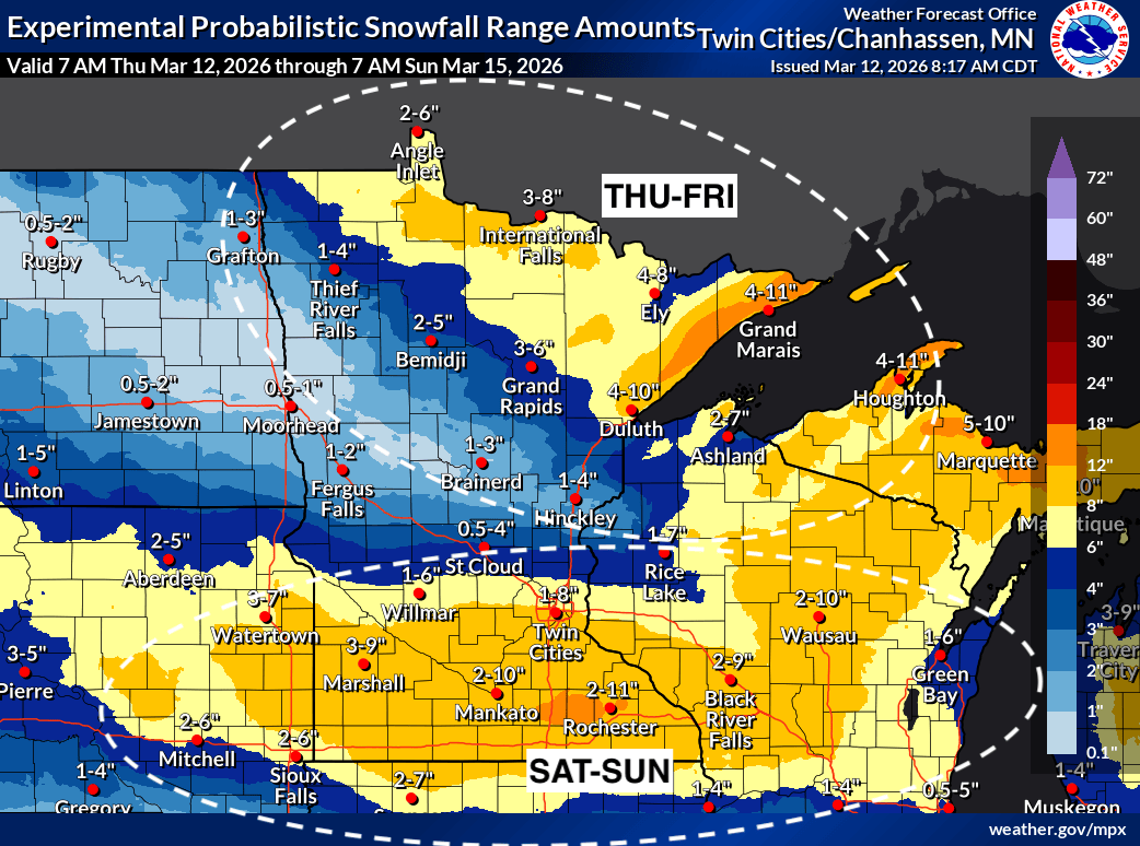
The initial storm system, described as a quick-moving clipper, began developing over the Northwest on Thursday. This system is already generating strong winds across the Rockies and Plains, prompting high wind alerts. According to the FOX Forecast Center, the intensifying low-pressure system has the potential to create whiteout conditions and widespread power outages. Snowfall is currently breaking out across northern Minnesota and Michigan, with accumulations of 5 to 8 inches expected, primarily north of Interstate 94. Blizzard warnings are in effect for regions along the Lake Superior shoreline in Minnesota, as the wind carries snow across the Great Lakes. Tampa Free Press reports that wind gusts could reach 75 mph.
⚠️ Blizzard Warning ⚠️ for portions of northern Minnesota through tonight! Heavy snow & strong winds will create dangerous conditions. Travel is not recommended. https://t.co/q9q9q9q9q9 pic.twitter.com/wJq9q9q9q9
— National Weather Service Duluth (@NWSDuluth) March 12, 2026
Second System to Amplify Impacts
Close on the heels of the first storm, a second and more powerful system is tracking out of the Pacific Northwest, expected to arrive by Friday afternoon. This system is being driven by a dip in the jet stream and will collide with cold air surging south from Canada. From Saturday through Monday, moderate to heavy snow is forecast for North Dakota, Minnesota, Wisconsin, Michigan, and parts of New England. The FOX Forecast Center indicates that the combined impact of these two storms could be substantial. “All told, more than 2 feet of snow could fall across parts of Wisconsin and Michigan through Monday,” the center reported, adding that over a foot of snow is possible in other sections of the Upper Midwest, Northern Plains, and New England. MSN News highlights the widespread nature of the impending storms.
Major hubs, including Minneapolis, Green Bay, and Marquette, are directly in the path of the second storm, where blowing snow is likely to severely limit visibility. The potential for significant disruptions to transportation, including road closures and flight cancellations, is high. Emergency responders are preparing for increased call volumes related to weather-related incidents, such as vehicle accidents and medical emergencies. Residents are advised to stock up on essential supplies, including food, water, medications, and batteries, and to avoid unnecessary travel during the peak of the storms.
Regional Breakdown of Expected Conditions
The specific impacts of the storms will vary by region. In the Northern Plains, North Dakota and Minnesota are expected to receive some of the heaviest snowfall totals, with accumulations potentially exceeding 18 inches. Wisconsin and Michigan are similarly bracing for significant snow, with some areas forecast to receive over two feet. New England is expected to experience a mix of snow and rain, with the heaviest snowfall likely in the northern and western parts of the region. The Upper Peninsula of Michigan is under blizzard warnings, anticipating snowfall between 9 inches and 2 feet, coupled with wind gusts up to 60 mph, as reported by ABC News.
Further south, areas from the Dakotas through the Great Lakes and into northern New England are expected to experience a combination of snow, strong winds, and rain. Blizzard warnings are currently in effect from Grand Forks and Fargo in North Dakota down to Rochester, Minnesota, and Mason City, Iowa, with snowfall projections between 3 and 8 inches and wind gusts reaching 45 mph. These conditions are expected to create whiteout conditions and near-zero visibility through Monday morning. A Flood Watch has also been issued for Buffalo and Jamestown, New York, due to the potential for up to 1.5 inches of rainfall.
Preparing for the Storms
Authorities are urging residents to take proactive steps to prepare for the storms. This includes ensuring vehicles are equipped with winter tires, having a fully charged cell phone and portable charger, and knowing the location of emergency shelters. We see also key to check on elderly neighbors and those with disabilities who may necessitate assistance. Power companies are preparing for potential outages and are advising customers to have a supply of flashlights, batteries, and non-perishable food on hand. The Red Cross is also offering guidance on winter storm preparedness on its website.
The storms are expected to move into the Midwest on Sunday afternoon, with snow already beginning to fall in Sioux Falls and Fargo as of early Sunday. The combination of heavy snow, strong winds, and cold temperatures will create hazardous conditions throughout the region. Residents are urged to stay informed about the latest weather updates and to heed the advice of local authorities.
Key Takeaways
- Two back-to-back winter storms are forecast to impact the Northern Plains, Upper Midwest, and New England.
- Snowfall accumulations could exceed two feet in some areas, particularly in Wisconsin and Michigan.
- Blizzard warnings are in effect for portions of Minnesota, Michigan, and the Dakotas.
- Residents are advised to prepare for potential power outages, travel disruptions, and hazardous conditions.
- Stay informed about the latest weather updates from the National Weather Service and local news sources.
The National Weather Service will continue to monitor the situation and provide updates as the storms evolve. The next significant update is expected on Monday morning, providing a clearer picture of the storm’s track and intensity. Residents are encouraged to monitor local news and weather reports for the latest information and to exercise caution during this period of inclement weather. Stay safe and prepared.
Keep reading