Multiple Storm Systems Set to Bring Snow and Potential Coastal Flooding to the Northeast
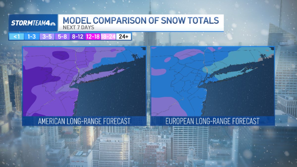
The Northeast is bracing for a series of winter weather events, with the potential for multiple rounds of snow and coastal flooding over the coming days. While the immediate threat of significant snowfall on Thursday has diminished, forecasters are closely monitoring a system expected to bring more substantial precipitation early next week. Residents should prepare for potentially hazardous travel conditions and the possibility of coastal impacts as the region navigates this active weather pattern.
Initial forecasts suggested a more impactful snowfall for Thursday, but recent model runs indicate that precipitation will likely remain south of the region, or at most, bring remarkably light snow brushing the southern edges. Temperatures hovering above freezing during the day are expected to limit any significant accumulation. However, conditions could become more wintry Thursday night, requiring continued vigilance.
Looking Ahead: A More Significant System Arriving Sunday
The focus is now shifting to a more substantial weather system expected to impact the region starting Sunday. A fast-moving cold front will bring likely snow showers, with a slight chance of brief snow squalls, particularly in areas further north. Temperatures will be milder on Saturday, reaching into the 40s Fahrenheit, before dropping Sunday evening as the snow begins to accumulate.
Snowfall rates could reach up to 2 inches per hour, accompanied by increasing winds, significantly reducing visibility. These conditions could potentially meet blizzard criteria, especially in Suffolk County, which experienced substantial snowfall from a previous storm. The strong winds are too expected to generate coastal flooding, with the highest risk occurring during Sunday night’s high tide.
This upcoming storm differs from the recent blizzard in that temperatures will be warmer, resulting in a wetter, heavier snow. This type of snow requires extra caution during shoveling. While the duration of the snowfall is expected to be shorter than the previous event, conditions will still be hazardous. Models currently suggest the region is positioned on the northern edge of the storm, increasing the likelihood of an all-snow event, though it is still too early to provide precise accumulation totals or timing.
Potential for Additional Snowfall Next Week
Beyond the Sunday-Monday system, another weather disturbance is anticipated to arrive Tuesday night into Wednesday. However, the track of this system remains uncertain. It may begin as snow but could transition to rain if it moves further north. Multiple opportunities for snowfall exist next week, but confidence in specific timing and amounts remains low. Details will continue to evolve as forecasters refine their models.
Following these potential snow events, a return to milder temperatures and chances for rain is expected by midweek. This shift in weather patterns suggests a temporary reprieve from the winter conditions, though continued monitoring of forecasts is advised.

The potential for significant weather impacts underscores the importance of staying informed and prepared. Residents should monitor local forecasts and heed any warnings issued by authorities. Given the possibility of hazardous travel conditions, it is advisable to exercise caution and allow extra time for commutes.
PHOTOS: Snowmen arise across the NYC area thanks to the blizzard
The next key update regarding the Sunday-Monday storm is expected on Friday afternoon, as forecasters gain a clearer understanding of the system’s track and intensity. We will continue to provide updates as they become available. Share your thoughts and preparations in the comments below, and please share this article with your network to help keep everyone informed.
Related reading