Oaxaca Braces for Intense Heat and Dry Conditions
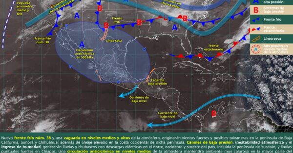
Oaxaca, Mexico is preparing for a period of sustained high temperatures and low rainfall, with conditions expected to be particularly severe in the central and eastern regions of the state. Authorities are urging residents to take precautions against heatstroke and dehydration as an intense anticyclonic circulation pattern dominates the weather system. The forecast, issued by the State Coordination of Civil Protection and Risk Management (CEPCyGR), indicates stable weather with clear to partly cloudy skies, intense solar radiation, and a minimal chance of precipitation, though isolated showers triggered by thermal shocks and local effects cannot be entirely ruled out.
The current weather pattern is driven by a strong high-pressure system situated in the middle and upper levels of the atmosphere, exerting a significant influence over the region. This anticyclonic circulation is suppressing cloud formation and contributing to the prolonged period of sunshine and rising temperatures. The National Water Commission (Conagua) forecasts a hot to very hot environment, with extreme temperatures anticipated, especially in the central and eastern areas of Oaxaca. This situation demands heightened awareness and proactive measures to mitigate potential health risks associated with prolonged exposure to heat.
Regional Temperature Outlook
Beyond the overall forecast, specific temperature ranges have been predicted for various regions within Oaxaca. These forecasts provide a more granular understanding of the expected conditions and allow for targeted preparation. The Valles Centrales (Central Valleys) are expected to experience a minimum temperature of 12°C (54°F) and a maximum of 33°C (91°F). The Isthmus of Tehuantepec will likely see a warmer range, with a minimum of 23°C (73°F) and a maximum of 36°C (97°F). The Cuenca del Papaloapan (Papaloapan Basin) is forecast to have a minimum of 18°C (64°F) and a maximum of 33°C (91°F). Coastal areas can expect a minimum of 22°C (72°F) and a maximum of 35°C (95°F). Inland, the Mixteca region will range from a low of 12°C (54°F) to a high of 32°C (90°F). The Sierra de Flores Magón mountains will experience a minimum of 15°C (59°F) and a maximum of 34°C (93°F). The Sierra de Juárez mountains will be cooler, with a minimum of 9°C (48°F) and a maximum of 26°C (79°F). Finally, the Sierra Sur (Southern Sierra) is predicted to have a minimum of 10°C (50°F) and a maximum of 28°C (82°F).
Wind Conditions and Air Quality
Adding to the challenging conditions, northerly winds are expected to continue, bringing with them strong dust storms during the afternoons and hazy conditions at dawn. These dust storms, known as *tolvaneras*, can significantly reduce visibility and pose respiratory hazards. The presence of *calima*, or airborne dust, will further impact air quality, particularly during the early morning hours. While mountainous areas will experience cooler temperatures during the night and early morning, the overall trend points towards a sustained period of heat across most of the state. Individuals with respiratory sensitivities are advised to take extra precautions and limit outdoor activities during periods of high dust concentration.
The combination of intense heat, dry conditions, and wind-blown dust creates a complex set of challenges for residents of Oaxaca. Understanding these conditions and taking appropriate preventative measures is crucial for protecting health and safety. The CEPCyGR emphasizes the importance of staying informed about the latest weather updates and following the recommendations of civil protection authorities and port captains.
Staying Informed and Safe
The CEPCyGR urges the public to heed the advice of Civil Protection and Port Captaincies and to remain informed about weather conditions through official channels. Updates and information can be found on Facebook at @CEPCyGRGobOax and on X (formerly Twitter) at @CEPCyGR_GobOax. These platforms provide real-time updates and guidance on how to prepare for and respond to the extreme weather conditions. Staying connected to these official sources is vital for ensuring personal safety and well-being during this period of heightened risk.
The current situation underscores the increasing frequency and intensity of extreme weather events globally, driven in part by climate change. While this specific forecast pertains to Oaxaca, it serves as a reminder of the importance of preparedness and resilience in the face of a changing climate. Communities around the world are facing similar challenges, and proactive measures are essential for mitigating the impacts of these events.
As the heatwave continues, We see crucial for residents to prioritize hydration, seek shade during peak hours, and avoid strenuous activity. Vulnerable populations, including the elderly, young children, and those with pre-existing health conditions, are particularly susceptible to heat-related illnesses and should take extra precautions. The CEPCyGR’s guidance and ongoing monitoring of the situation will be critical in ensuring the safety and well-being of the population.
The State Coordination of Civil Protection and Risk Management (CEPCyGR) continues to monitor the situation closely and will provide further updates as needed. Residents are encouraged to stay tuned to official channels for the latest information and guidance. The next official update from the CEPCyGR is expected within 24 hours, providing a more detailed assessment of the evolving weather conditions and any potential adjustments to safety recommendations. Please share this information with your networks and stay safe.
Related reading