Millions of people across the United States are currently monitoring an expansive and dangerous weather pattern as severe storms threaten a significant portion of the country, bringing risks of flash flooding, damaging winds, and large hail. Meteorologists have identified a high-impact weather system stretching from the Plains to the Midwest, with forecasts indicating that over 88 million people could face some level of impact from these volatile conditions throughout the week. Residents in the affected regions are being urged to remain vigilant as the environment remains primed for rapid storm development.
Severe Weather Outlook and Geographic Impact
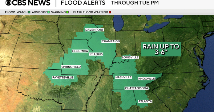
The current meteorological threat involves a series of complex storm systems that are expected to track across a wide swath of the American heartland. According to the National Weather Service, the primary hazards associated with this active pattern include the potential for localized flash flooding, particularly in areas where ground saturation levels are already high. The threat is not limited to one specific region; instead, it encompasses a broad corridor extending from Texas through the Missouri Valley and into the Northern Plains. This geographic diversity means that the type of threat—whether it be wind, hail, or torrential rain—will vary significantly by location.
In the Northern Plains, officials have been monitoring the potential for what are described as explosive storm developments. These systems are capable of producing intense wind gusts and large hail, which can cause localized infrastructure damage and disrupt power grids. The atmospheric instability driving these storms is fueled by a clash of air masses, a common phenomenon during this time of year that often results in rapid intensification. For real-time updates and localized alerts, citizens are encouraged to monitor the National Oceanic and Atmospheric Administration (NOAA) official bulletins, which provide the most accurate data on storm tracks and hazard warnings.
How to Stay Safe During Severe Weather
With millions under potential threat, emergency management agencies emphasize the importance of preparedness. The risk of flash flooding, in particular, poses a significant danger to motorists and those in low-lying areas. Experts consistently advise that individuals should never attempt to drive through flooded roadways, as the depth of the water and the stability of the surface underneath are often deceptive. As noted in guidance from the Federal Emergency Management Agency (FEMA), having a communication plan and a designated shelter location is essential for every household in high-risk zones.
Beyond flooding, the threat of high winds requires residents to secure outdoor items that could become projectiles. The reports of extreme wind speeds in areas like North Dakota serve as a stark reminder of the destructive power these systems can carry. Staying informed through local news outlets and reliable weather radio services is the most effective way to receive timely warnings. Because conditions can shift rapidly, relying on official National Weather Service updates rather than secondary social media reports is recommended to ensure you are acting on the most current data.
The Science Behind the Current Pattern
The current weather event is characterized by a persistent pattern that allows multiple rounds of precipitation and storm activity to move across the central United States. When warm, moist air from the Gulf of Mexico pushes northward and encounters cooler, drier air moving down from Canada, it creates the instability necessary for severe thunderstorms. This cycle is expected to persist for several days, keeping emergency crews and local authorities on high alert. The cumulative effect of these storms is what raises the total number of people affected into the millions, as the systems traverse densely populated areas and agricultural regions alike.

While the immediate focus is on the current week, the long-term impact of such frequent severe weather events continues to be a subject of study by climate researchers. According to the National Centers for Environmental Information, tracking the frequency of these high-impact events helps communities better prepare their infrastructure for future challenges. For now, the focus remains on the immediate safety of the public as the storms continue to evolve. Residents should check their local government websites for specific emergency declarations or evacuation guidance, as these are issued at the county or state level based on immediate environmental conditions.
The situation remains fluid, with the next update from the Storm Prediction Center expected to refine the areas of highest risk as the weather systems move eastward. If you live in an area currently under a watch or warning, please prioritize your safety by staying indoors and away from windows during peak storm activity. We will continue to monitor these developments and provide updates as official reports emerge. Please feel free to share your experiences or local updates in the comments section below.
Related reading
- Woman’s Animal Costume Dance at Gentse Feesten Leads to Huge Surprise from Partner
- Why Iran’s Regime Survives: The Doctrine of Clerical Rule and Repression
- Mass Shootings in Western Cape: Multiple Dead Across Cape Town (archynewsy.com)
- Severe Weather Hits Sioux Falls, SC, as Storm System Moves East (news-usa.today)