
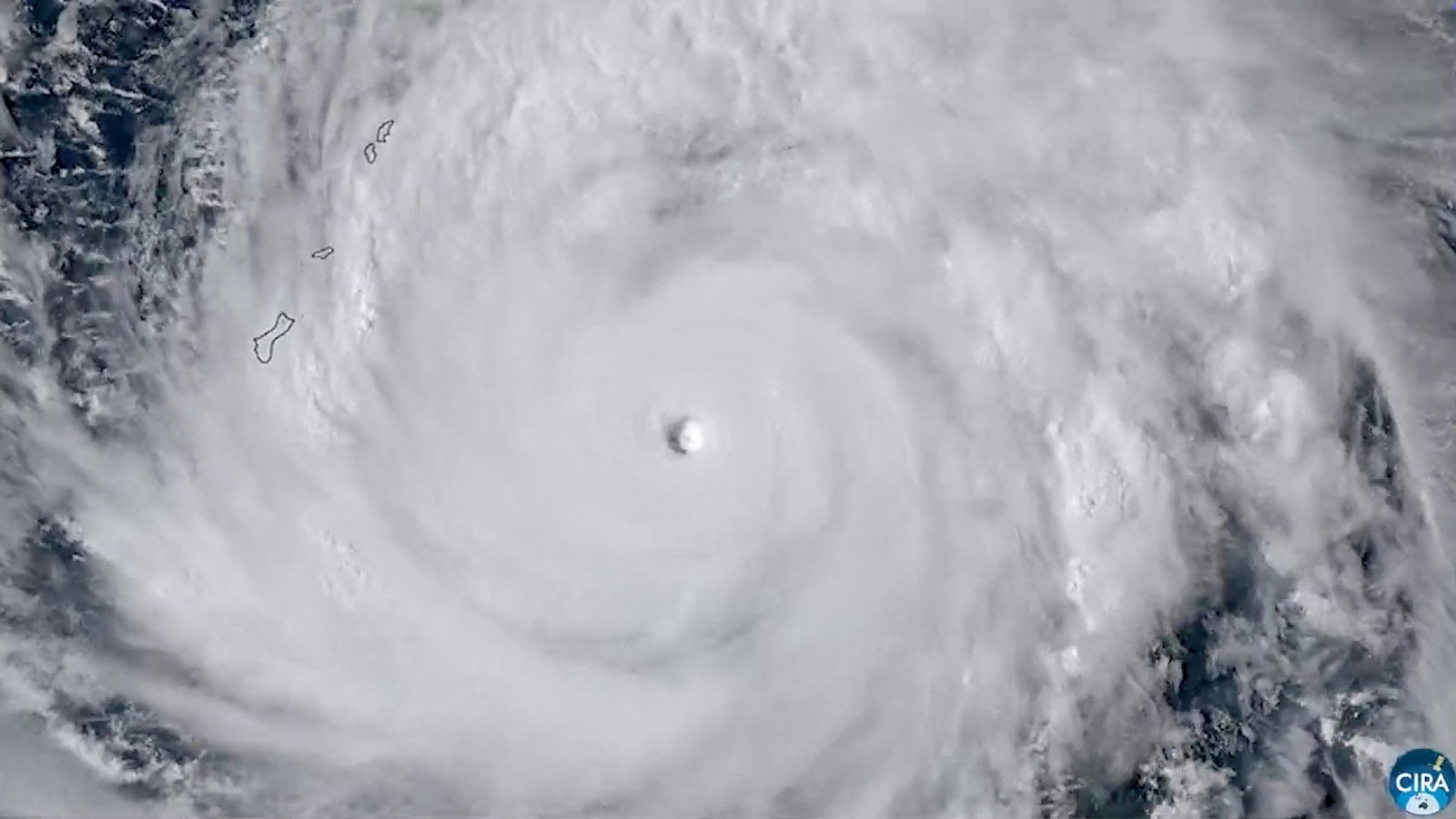
As of Monday morning, April 13, 2026, the Pacific region is bracing for the arrival of Super Typhoon Sinlaku, a Category 5 storm that is currently tracking toward the U.S. Territories of Guam and the Northern Mariana Islands. With sustained winds reaching up to 180 miles per hour, the storm poses a severe threat to infrastructure and public safety across the islands according to reports from the Guam Press.
The scale of the storm has triggered high-level alerts and the mobilization of international disaster relief. While current trajectories suggest the most catastrophic impact will be felt in the Northern Mariana Islands, officials in Guam remain on high alert, warning that a southward shift in the storm’s path could bring typhoon-force winds to the island.
The imminent Super Typhoon Sinlaku impacts are expected to include destructive winds, torrential rainfall and significant flooding. The National Weather Service (NWS) and the Joint Typhoon Warning Center are closely monitoring the system as it moves toward the Marianas, prompting residents to seek shelter in sturdy concrete buildings to avoid the potential for catastrophic structural damage.
Current Trajectory and Storm Intensity
As of Monday morning, Super Typhoon Sinlaku was located approximately 340 miles east-southeast of Guam, moving toward the Marianas at a speed of about 10 miles per hour as reported by the Guam Press. The storm has already reached Category 5 status, the highest classification on the Saffir-Simpson scale, with wind speeds peaking at 180 mph.
Weather models indicate that the storm is expected to intensify further as it approaches the islands. The primary targets for the storm’s core are Saipan and Tinian, both part of the Commonwealth of the Northern Mariana Islands (CNMI). These islands are expected to experience the brunt of the storm by Tuesday, with maximum winds forecasted up to 145 miles per hour per the NWS.
Immediate Threats and Warnings for Guam
Guam remains in Condition of Readiness 2, a status indicating that damaging winds are expected within 24 hours. While the risk of Guam experiencing the absolute worst of the storm has been reduced, the threat remains significant. A tropical storm warning and a typhoon watch are currently in effect for the island, meaning winds up to 74 miles per hour are expected within 24 hours, and typhoon-force winds over 74 mph remain possible within 48 hours according to NWS forecasts.
Residents of Guam should prepare for the following conditions between Monday night and Wednesday:
- Tropical storm-force winds ranging from 40 to 50 miles per hour.
- Wind gusts reaching up to 60 miles per hour.
- Heavy rainfall and potential flash flooding, for which a flash flood watch is currently in effect.
- Dangerous coastal conditions, supported by an active high surf warning.
Meteorologists warn that if Sinlaku makes a southward shift in its track, Guam could be subjected to much more severe typhoon-force winds exceeding 74 miles per hour.
Catastrophic Outlook for Saipan and Tinian
The forecast for the Commonwealth of the Northern Mariana Islands is significantly more dire. The storm is expected to make landfall over the Marianas today, potentially bringing wind speeds of 175 mph and as much as 20 inches of rain according to the American Red Cross. Tinian and Saipan are anticipated to suffer the greatest damage.
The potential impacts on the CNMI include:
- Structural Damage: The extreme wind speeds are likely to cause widespread damage to buildings and infrastructure.
- Utility Failures: Prolonged power outages are expected, and the water supply across the islands may be compromised.
- Flooding: With up to 20 inches of rain forecast, catastrophic flooding is a primary concern for local authorities.
Humanitarian Response and Emergency Measures
In response to the approaching super typhoon, the American Red Cross has prepositioned disaster teams and essential supplies on both Guam and the Mariana Islands. More than 100 trained disaster volunteers from across the United States have been deployed to the region to assist those impacted by the storm per official Red Cross communications.
Emergency shelters have been opened in partnership with local Education Departments. As of Sunday night (and Monday night in Guam), more than 700 people had already sought refuge in these shelters, a number that is expected to rise as the storm nears landfall according to the Red Cross.
Federal support is similarly being coordinated, with President Donald Trump approving emergency measures for the Governor of Guam to facilitate the response and recovery efforts.
Summary of Storm Forecasts
| Location | Expected Max Winds | Key Risks | Timeline |
|---|---|---|---|
| Guam | 40-60 mph (Potential 74+ mph) | Flash floods, high surf, damaging gusts | Monday night – Wednesday |
| Saipan & Tinian | 145-175 mph | Catastrophic structural damage, 20″ rain, power outages | Tuesday landfall |
Residents in the affected areas are strongly urged to follow the guidance of local officials and the National Weather Service. Those in vulnerable structures should evacuate to official shelters or seek refuge in sturdy concrete buildings immediately.
The next critical update will follow as the storm makes landfall in the Northern Mariana Islands on Tuesday. We will continue to monitor the track and intensity of Super Typhoon Sinlaku to provide the latest safety and impact information.
Do you have family or colleagues in the Pacific territories? Share this article to ensure they have the latest safety warnings, and leave your comments below on how your community is preparing for the storm.