Meteorologists in Taiwan are warning of an extended period of severe weather as a stationary front, coupled with a strengthening southwest monsoon, moves across the island. The Central Weather Administration (CWA) has issued advisories for heavy rainfall, cautioning that the combination of these two systems is likely to trigger significant and potentially hazardous weather conditions through the coming week.
The current atmospheric setup, characterized by a lingering frontal system interacting with moisture-laden winds from the southwest, has created a high risk for large-scale, persistent rainfall. Experts emphasize that the intensity of this weather pattern is expected to fluctuate, with specific concerns regarding the impact on mountainous regions where cumulative precipitation could be particularly high. Residents are advised to monitor official updates from the Central Weather Administration frequently as the situation evolves.
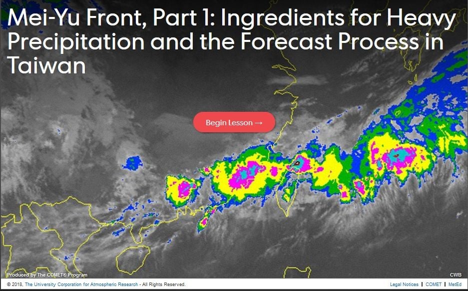
Understanding the Mechanics of the Current Rainfall
The phenomenon currently affecting Taiwan involves a “stationary front”—a boundary between air masses that remains in place for an extended period—stalled over the region. When this front draws in a robust southwest monsoon, the result is a sustained “conveyor belt” of moisture. This interaction is a classic signature of the “Meiyu” or plum rain season in East Asia, which often brings prolonged, heavy precipitation.
Meteorologists have noted that while the rainfall will not be uniform across the island, the persistence of the system means that even areas experiencing temporary breaks in the weather remain at risk of sudden, intense downpours. The threat is not limited to immediate flooding; the saturation of soil in mid-to-high altitude areas significantly increases the risk of landslides and debris flows. Authorities have urged the public to exercise heightened caution when traveling through mountainous terrain or low-lying areas prone to sudden water accumulation.
What to Expect in the Coming Days
Weather forecasts indicate that the period of instability is likely to persist for several days, with the heaviest concentrations of rainfall expected to shift depending on the precise positioning of the front. As of the latest updates from the CWA, the pattern is expected to maintain a high level of activity, meaning that “purple-level” rainfall—an indicator of extremely heavy accumulation—could occur in localized areas.
For those living in central and southern regions, the potential for high-volume rainfall is particularly acute. These areas often receive the brunt of the moisture channeled by the southwest monsoon. The Central Weather Administration maintains a real-time dashboard and warning system to help citizens track the movement of the front. It is recommended that residents check their local municipal government websites for specific emergency alerts or school and work suspension announcements, which are issued based on localized risk assessments.
Safety Guidance and Official Resources
In anticipation of potential flooding and traffic disruptions, emergency management agencies suggest taking proactive steps to secure property and ensure personal safety. This includes clearing drainage paths around homes, avoiding coastal activities during high tide and heavy rain, and staying informed through verified meteorological channels.

To stay updated with the most accurate and timely information, the public should rely on the following official sources:
- Central Weather Administration (CWA): For official forecasts, satellite imagery, and weather warnings.
- National Fire Agency: For emergency response guidelines and disaster prevention tips.
- Local City and County Government websites: For region-specific information regarding flood mitigation and potential closures.
The current weather pattern is a reminder of the volatility inherent in the regional climate during the early summer months. As the situation remains fluid, meteorologists will continue to refine their models. The next major update from the CWA is expected following the analysis of the latest observational data. We encourage our readers to share this information with those in affected areas and to remain vigilant as the week progresses.
Keep reading
- Videó: Süllyedni kezdett egy utasokkal teli hajó az Erzsébet hídnál, hétórás küzdelemmel akadályozták meg a legrosszabbat – Szeretlek Magyarország
- Ryanair Flight Diverted to Dublin Due to Passenger Illness
- Jānis Slaidiņš States Hybrid Threats Outweigh Baltic Invasion Risks (archyworldys.com)
- Southwest Albany Building Undergoes Major Reconstruction (news-usa.today)