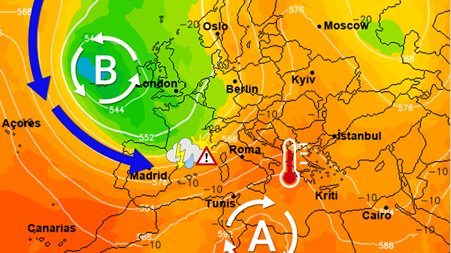
As the Northern Hemisphere transitions into the peak of the summer season, meteorologists are tracking a significant shift in atmospheric patterns that promises to redefine weather expectations for much of Europe. While many anticipate the steady, sun-drenched days typical of June, recent data suggests a radical change in circulation is imminent, potentially bringing increased instability to some of the continent’s most sensitive geographic regions.
This meteorological pivot is expected to manifest most prominently in the early stages of the month. The shift in air mass movement is projected to disrupt the prevailing calm, introducing a more volatile pattern of weather that could lead to sudden and intense atmospheric events. For those living in or traveling through the mountainous corridors of Europe, this change marks a critical transition from the gentle breezes of late spring to the more aggressive, convective energy of early summer.
The core of this transition lies in the reconfiguration of high- and low-pressure systems across the Mediterranean and the Atlantic. As these systems interact, the resulting circulation patterns are set to create a “tug-of-war” between warm, moist air masses and cooler, more stable currents. According to current atmospheric modeling, this interaction is particularly poised to impact the Alpine and Pre-Alpine regions, where the terrain itself plays a decisive role in amplifying weather volatility.
Understanding the Atmospheric Shift: The Mechanics of Circulation
To understand why June is witnessing such a dramatic change, one must look at the behavior of the jet stream and the positioning of subtropical high-pressure cells. Throughout the spring, the jet stream—a high-altitude ribbon of fast-moving air—tends to follow a more predictable, zonal path. However, as we enter June, this path often becomes more “meridional,” or wavy. These waves allow polar air to dip further south and tropical air to surge further north, creating the very instability we are currently observing.
The radical change in circulation mentioned in recent meteorological forecasts refers to this destabilization of the atmospheric flow. When the jet stream becomes wavy, it creates “blocking” patterns where certain weather systems become stationary. This can lead to prolonged periods of heat in some areas, followed immediately by the arrival of intense low-pressure systems that bring heavy precipitation. This rapid oscillation is a hallmark of the seasonal transition, but the intensity of the current shift suggests a particularly active period ahead.
the warming of the Mediterranean Sea plays a crucial role in this dynamic. As sea surface temperatures rise, the amount of moisture available in the lower atmosphere increases. When this moisture-laden air is pulled northward by changing circulation patterns, it provides the “fuel” necessary for significant storm development. The Copernicus Climate Change Service has frequently noted that rising sea temperatures in the Mediterranean are a primary driver of increased convective activity across Southern and Central Europe.
The Alpine Vulnerability: Why the Mountains Feel the Change
While the circulation change is a continental-scale event, its impact is not distributed equally. The Alpine and Pre-Alpine regions are uniquely susceptible to these shifts due to a phenomenon known as orographic lift. This occurs when moving air is forced upward by the physical barrier of a mountain range. As the air rises, it cools and expands, a process that triggers condensation and the formation of clouds.
In a stable weather pattern, orographic lift might simply result in localized mist or light afternoon showers. However, under the “radical change in circulation” currently being forecasted, the incoming air masses are expected to be significantly more unstable. When this unstable, moisture-rich air hits the massive vertical walls of the Alps, the orographic lift acts as a catalyst, accelerating the development of deep convective clouds. This can turn a routine weather shift into a series of localized but severe weather events.
The Pre-Alpine areas—the foothills that transition from the plains to the high mountains—are also at high risk. These regions often act as the “staging ground” for incoming weather fronts. As air masses move from the broader European plains toward the mountains, they can become trapped and concentrated in the valleys, leading to intense, localized rainfall and sudden changes in visibility. For hikers, mountaineers, and local residents, this means that weather conditions can shift from clear skies to heavy storms in a matter of minutes.
Thunderstorm Season: The Rise of Convective Activity
One of the most significant outcomes of this changing circulation is the anticipated increase in thunderstorm activity. Unlike large-scale frontal systems that may move slowly across a continent, thunderstorms are often “convective,” meaning they are driven by the upward movement of warm, buoyant air. In June, the combination of high solar radiation and increased atmospheric moisture creates the perfect environment for these cells to form.

The forecast indicates that these thunderstorms could “gain space” across the region, moving beyond the high peaks and into the surrounding valleys and lower-lying areas. These are not merely rain showers. they are likely to be characterized by:
- Rapid Temperature Drops: The arrival of a thunderstorm can cause local temperatures to plummet by several degrees in a very short window.
- High-Intensity Precipitation: Sudden, heavy downpours can lead to localized flooding, particularly in areas with steep terrain where runoff is immediate.
- Lightning and Electrical Activity: The increased energy in the atmosphere raises the frequency of lightning strikes, posing a risk to outdoor activities.
- Gusty Winds: Downbursts—localized columns of sinking air—can produce sudden, damaging winds at the surface.
Meteorologists emphasize that the timing of these events is often unpredictable. Because convective storms are localized, one valley may experience a calm, sunny afternoon while a neighboring valley is hit by a severe thunderstorm. This “patchwork” weather pattern requires constant monitoring and high levels of situational awareness from anyone operating in the Alpine regions.
| Feature | Stable Circulation (Typical) | Unstable Circulation (Forecasted) |
|---|---|---|
| Air Mass Movement | Consistent, zonal flow | Wavy, meridional flow |
| Precipitation Type | Light, predictable showers | Intense, convective thunderstorms |
| Temperature Trends | Gradual warming | Rapid fluctuations |
| Primary Risk Area | Broad, regional patterns | Localized Alpine/Pre-Alpine zones |
Broader Climate Context: Summer Patterns in Europe
While this specific shift in June is a seasonal occurrence, it must be viewed within the broader context of changing climate trends in Europe. The World Meteorological Organization (WMO) has documented an increase in the frequency and intensity of extreme weather events across the continent. The “radical changes” in circulation that we see today are increasingly characterized by higher energy levels.
As the atmosphere warms, it can hold more water vapor—approximately 7% more for every degree Celsius of warming. This physical reality means that when circulation patterns do shift to bring rain, the resulting precipitation is often more voluminous and destructive than in previous decades. The transition into summer is no longer just a move toward warmth; We see a move toward a more energetic and potentially hazardous atmospheric state.
For policymakers and regional planners, this necessitates a shift in how weather-related risks are managed. From mountain rescue services to agricultural planning, the ability to predict and react to sudden, high-intensity convective events is becoming a critical component of regional resilience. The trend suggests that the “old rules” of seasonal weather may no longer be sufficient for navigating the complexities of the modern European summer.
Key Takeaways
- Atmospheric Shift: A radical change in circulation is expected in June, driven by a more wavy jet stream and shifting pressure systems.
- Regional Impact: The Alpine and Pre-Alpine regions are at the highest risk due to orographic lift and terrain-driven instability.
- Storm Warning: Expect an increase in convective thunderstorms, characterized by heavy rain, lightning, and sudden temperature drops.
- Climate Factor: Rising Mediterranean sea temperatures are fueling the moisture levels that drive these intense storms.
- Unpredictability: Weather patterns are likely to be localized, meaning conditions can change rapidly within very small geographic areas.
Frequently Asked Questions
Q: How will this weather affect mountain travel?
A: Travelers should expect sudden changes in visibility and weather. It is essential to check local mountain-specific forecasts frequently and be prepared for rapid temperature drops and heavy rain.
Q: Why are the Alps more affected than the plains?
A: The mountains force air upwards (orographic lift), which accelerates the cooling and condensation process, making storms much more likely and intense in mountainous terrain.
Q: Is this a permanent change in June weather?
A: While seasonal shifts are normal, the increasing intensity and volatility are consistent with broader long-term climate trends observed across Europe.
As we continue to monitor these atmospheric developments, the next critical window for updated modeling will occur following the next major pressure system shift. We recommend following local meteorological services for real-time updates and safety advisories.
What have you noticed about the weather in your region this month? Are you seeing more sudden shifts? Let us know in the comments below and share this article with anyone planning mountain activities this summer.