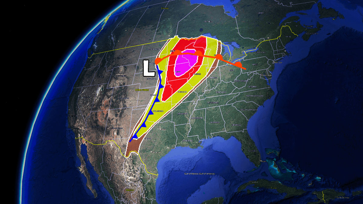
Severe thunderstorms swept across the Midwest on April 14-15, 2026, producing multiple tornadoes, large hail, and damaging winds that affected communities from eastern Iowa into southern Wisconsin. The National Weather Service confirmed the event as part of a broader severe weather outbreak that impacted the region during the mid-April period.
According to the National Weather Service’s Quad Cities forecast office, the storms developed Tuesday afternoon and evening, bringing numerous reports of large hail, damaging wind, and several tornadoes. The U.S. Highway 20 corridor experienced a long-lived supercell that produced baseball-sized hail, wind gusts up to 88 mph at Dubuque Airport, and multiple tornadoes. Additional storms formed further south between Interstate 80 and Highway 20, contributing to the widespread severe weather across the region.
AccuWeather reported that six tornadoes were documented across eastern Iowa and southern Wisconsin during the outbreak, with hail reaching up to 4 inches in diameter—comparable to grapefruit size—in some areas. The storms caused damage to homes and vehicles, including reports of blown-off roofs in Independence, Iowa, where a warehouse structure was significantly damaged. Storm chaser Brandon Clement captured video of a rope tornado moving through rural Wyoming, Iowa, on April 14, providing visual documentation of the event.
The severe weather prompted concern over flooding as heavy rainfall accompanied the storms, raising the risk of flash flooding in parts of the Midwest. Damage assessments were underway in the days following the event, with meteorologists and emergency officials evaluating the full scope of impacts across affected communities.
Tornado Activity and Severe Weather Reports
The National Weather Service’s preliminary data for April 2026 indicates that 72 tornadoes were confirmed across the United States during the month, based on reports from various forecast offices. This total includes 6 EFU-rated tornadoes, 20 EF0, 41 EF1, 4 EF2, and 1 EF3. The Enhanced Fujita scale categorizes tornadoes by estimated wind speed and resulting damage, with EF0 representing winds of 65-85 mph and EF3 indicating winds of 136-165 mph capable of causing severe structural damage.

In the April 14-15 outbreak specifically, the storms produced conditions favorable for tornado formation, including strong wind shear and atmospheric instability. The combination of these factors supported the development of supercell thunderstorms, which are known for producing the most intense and long-lived tornadoes. Radar imagery from the National Weather Service showed persistent rotation within several storm cells as they moved across eastern Iowa and western Wisconsin.
Hail reports from the event included multiple instances of stones measuring 2 inches or larger in diameter, with the largest reports reaching 4 inches—approximately the size of a grapefruit. Such large hail can cause significant damage to property, vehicles, and crops, and poses a serious risk to anyone exposed outdoors during a storm. The National Weather Service advises seeking shelter immediately when large hail is reported, as impacts can occur with little warning.
Emergency Response and Public Safety
Local emergency management agencies in affected counties activated severe weather protocols as the storms approached, issuing warnings through wireless emergency alert systems and local media outlets. Residents were advised to seek shelter in basements or interior rooms on the lowest floor of sturdy buildings, away from windows. Mobile home residents were specifically encouraged to seek alternative shelter, as these structures offer limited protection during tornado events.
The Storm Prediction Center had highlighted the Midwest as an area of elevated severe weather risk in the days leading up to the outbreak, noting the potential for damaging winds, large hail, and tornadoes. As the system evolved, updates were issued through the National Weather Service’s network of forecast offices, providing real-time information to the public and emergency responders.
In the aftermath, community organizations and disaster relief groups began assessing needs in areas hardest hit by the storms. The American Red Cross and local volunteer organizations typically assist with shelter, food distribution, and cleanup efforts following severe weather events, though specific deployment details for this outbreak were not independently verified in available sources.
Historical Context and Weather Patterns
April is historically one of the more active months for tornadoes in the United States, particularly as warmer air masses initiate to interact with lingering cooler systems across the central plains and Midwest. Based on 1991-2020 averages, approximately 182 tornadoes occur nationwide during the month of April, with activity generally increasing from south to north as the season progresses.
The 2026 April tornado count of 72 confirmed cases represents a below-average total compared to long-term norms, though monthly totals can vary significantly from year to year. Tornado activity tends to shift northward and westward later in the spring and early summer, with the traditional “Tornado Alley” regions of Oklahoma and Texas often seeing peak frequency earlier in the season, while states like Iowa, Minnesota, and Wisconsin may experience heightened risk in late April and May.
Meteorologists note that while individual outbreaks cannot be directly attributed to long-term climate trends, researchers continue to study how changing atmospheric conditions may influence severe weather patterns over time. Factors such as increased atmospheric moisture content and shifts in jet stream behavior are among the areas being examined for their potential influence on storm development and intensity.
Staying Informed During Severe Weather
For real-time updates during severe weather events, the National Weather Service recommends monitoring local forecast offices through weather.gov, enabling wireless emergency alerts on mobile devices, and following guidance from local emergency management officials. NOAA Weather Radio provides continuous broadcasts of official weather warnings, watches, and forecasts directly from nearby National Weather Service offices.
The Storm Prediction Center issues convective outlooks several days in advance of potential severe weather, highlighting areas at risk for thunderstorms capable of producing damaging winds, large hail, or tornadoes. These outlooks are updated regularly as forecast confidence increases, helping communities prepare for potential impacts.
After a severe weather event, official storm reports and damage assessments are typically published by the National Weather Service in the days and weeks following. These reports contribute to the official tornado database maintained by the National Centers for Environmental Information, which serves as the authoritative record of tornado occurrences in the United States.
As recovery efforts continue in communities affected by the April 14-15, 2026 storms, officials encourage residents to remain vigilant for additional severe weather threats, particularly during the peak spring and early summer months when atmospheric conditions are most favorable for intense thunderstorm development.
Worth a look