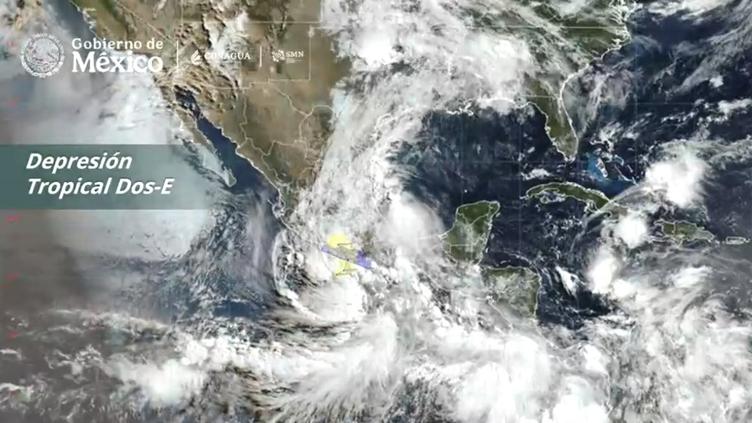
As of June 7, 2026, the Mexican government has issued urgent warnings regarding the development of Tropical Depression Two-E, which is currently impacting weather conditions along the country’s Pacific coastline. The Servicio Meteorológico Nacional (SMN) has reported that this weather system is bringing intense, and in some areas torrential, rainfall to the region, particularly affecting the state of Guerrero.
The system is part of a broader, sustained period of heavy precipitation that has been affecting much of Mexico throughout the weekend. Authorities have officially called for increased preventive measures as the depression continues to influence atmospheric conditions near the coast. The SMN maintains constant monitoring of the trajectory and intensity of the disturbance to provide timely updates to the public and emergency response agencies. Residents in affected areas are encouraged to follow official guidance from civil protection authorities as the situation evolves.
Meteorological Status and Regional Impact
The current weather alert stems from the formation of Tropical Depression Two-E, which has triggered a significant temporal period of rainfall across several states. According to the Servicio Meteorológico Nacional (SMN), the system is producing heavy rainfall with potential totals reaching between 150 and 250 millimeters in specific zones of Guerrero. These conditions are expected to persist, keeping the region under high alert for potential flooding and landslides.
While the depression continues to move, the primary concern remains the intensity of the precipitation. The SMN’s latest bulletins emphasize that the rainfall is not limited to a single point but is part of a wider weather pattern affecting a large portion of the national territory. For those in the path of the system, the priority remains monitoring official channels for real-time safety advisories and evacuation notices if conditions deteriorate further.
Safety Measures and Public Response
The government of Mexico has explicitly called for residents to exercise caution and adhere to established safety protocols. As the depression moves through the coastal zones, the primary focus is the mitigation of risks associated with torrential downpours. The SMN provides ongoing technical updates, which serve as the foundation for the coordination of civil protection efforts across the affected states. The agency emphasizes that the temporal nature of these rains requires sustained vigilance rather than a short-term response.
For citizens, the most effective way to stay informed is through the official channels of the Mexican meteorological service. Official updates are released frequently, reflecting the changing nature of the depression. Residents should avoid crossing flooded areas and remain aware of local emergency contact information provided by their municipal government.
Understanding Tropical Depression Forecasts
Tropical depressions are defined by their low-pressure centers and sustained wind speeds, which require careful tracking by meteorologists. The current system, identified as Two-E, is being analyzed for its potential to evolve into a more significant tropical storm. The SMN continues to provide updates on the system’s development, movement, and the expected duration of the heavy rainfall.
The systematic tracking of these events is critical for public safety. By analyzing satellite data and atmospheric pressure readings, the SMN determines the likelihood of intensification. As of June 7, 2026, the focus remains on the immediate threats posed by the current rainfall. Future developments regarding the system’s status will be issued by the SMN as they become available through their official monitoring portal.
The situation remains fluid. We will continue to track the progress of the depression and provide updates as official information is released by the relevant authorities. Please share this information with your local community to ensure everyone is aware of the current meteorological warnings. We invite readers to monitor the official SMN website for the most accurate and up-to-the-minute data regarding weather alerts in their specific regions.
Keep reading