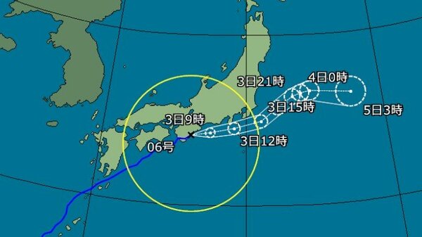
LONDON — As June begins, weather authorities in Japan are issuing urgent warnings regarding Typhoon No. 6, known internationally as Chanthu. The storm is currently tracking toward the Japanese archipelago, bringing the threat of severe weather conditions to the Pacific coast. Meteorological agencies have highlighted the risk of intense rainfall, particularly in the Kanto-Koshin region, where precipitation totals are expected to be significant as the system approaches.
The Japan Meteorological Agency (JMA) has released comprehensive guidance warning that the storm’s trajectory places it on a path to move near the Pacific side of western and eastern Japan by June 3. Residents in these areas are being advised to remain vigilant, as the combination of the typhoon’s movement and moisture-laden air increases the likelihood of linear precipitation zones—often referred to as senjo-kousuitai—which can lead to rapid, localized flooding and landslides. Detailed information regarding current warnings and localized weather updates can be found through the Japan Meteorological Agency’s official portal.
Anticipated Impact and Regional Risks
As of Tuesday, June 2, 2026, the storm’s influence is already being felt, with reports of extremely heavy rain across the Tokai region. Meteorologists are closely monitoring the situation as the typhoon’s outer bands reach the Kanto area. Forecasters have indicated that heavy rain and strong winds are expected to intensify through the afternoon hours, posing potential disruptions to infrastructure and daily travel.
The primary concern for regional authorities is the potential for record-breaking rainfall. In the Kanto-Koshin region, initial forecasts suggest that rainfall could reach 200 millimeters in localized areas. Such intense downpours, especially if concentrated by a linear precipitation zone, can quickly overwhelm drainage systems and trigger emergency alerts. Information regarding local disaster prevention and evacuation guidance is managed by municipal governments, and residents are encouraged to monitor their local Cabinet Office Disaster Management resources for real-time instructions.
Safety Measures and Preparedness
In light of the projected path, officials are urging the public to prioritize safety and consider evacuation plans before conditions deteriorate further. Level 3 heavy rain warnings have been issued for parts of Tokyo, signaling that elderly residents and those requiring additional time to evacuate should begin preparations immediately. The unpredictable nature of linear precipitation zones means that conditions can shift rapidly, making it vital to stay informed via official channels rather than relying on social media rumors.

Key safety recommendations provided by disaster management agencies include:
- Monitoring official JMA alerts for real-time updates on storm trajectory and rainfall intensity.
- Reviewing the location of the nearest designated evacuation centers provided by local municipal offices.
- Securing outdoor items that could become airborne in high winds.
- Preparing an emergency “go-bag” with essential supplies, including water, non-perishable food, and important documents.
Understanding Linear Precipitation Zones
The phenomenon of senjo-kousuitai, or linear precipitation zones, is a critical factor in the current emergency planning. These zones occur when cumulonimbus clouds form in a line and remain stationary over a specific area for an extended period, leading to catastrophic rainfall totals. Because these events are notoriously difficult to predict with high precision, meteorologists often issue “forecast information” rather than definitive warnings, allowing the public to begin early preparations for the possibility of a disaster.
The current weather situation underscores the importance of regional cooperation between meteorological services and local municipalities. By identifying the potential for these zones early, authorities aim to reduce the risk of casualties by ensuring that residents in high-risk areas are prepared to move to safety before the onset of the most severe weather.
Next Steps for Residents
The situation remains fluid, and the next confirmed checkpoint for the public will be the updated trajectory and intensity reports issued by the Japan Meteorological Agency throughout the night and into the early morning of June 3. Authorities will continue to release hourly updates, and any shifts in the storm’s speed or direction will be reflected in revised emergency warnings.

Residents in the path of the storm are advised to check their local government websites for specific evacuation orders. For those traveling in the affected regions, This proves recommended to monitor rail and air traffic status, as significant delays and cancellations are likely during the peak of the storm. We will continue to provide updates as official data becomes available.
Jonathan Reed serves as the News Editor for World Today Journal, covering international developments from the London newsroom. If you have found this report helpful, please consider sharing it with those who may be in the affected regions. We welcome your comments and questions on our coverage of global weather events.
Worth a look