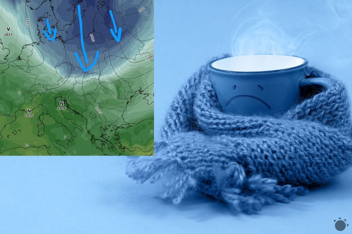
Arctic air is sweeping across Europe once again, bringing a sharp return of winter conditions to Slovakia. Meteorologists confirm that a tongue of cold air originating from the Arctic is moving southward, set to affect much of the country with freezing temperatures and renewed snowfall in higher elevations. This marks another significant cold snap in what has been a fluctuating winter season across Central Europe.
The development follows a period of milder weather earlier in January, during which temperatures briefly rose above seasonal averages. Now, forecasters warn of a rapid reversal, with Arctic air expected to penetrate as far south as western and central Europe. In Slovakia, the impact will be most pronounced in northern and northeastern regions, where temperature drops could reach double-digit negatives both day and night.
According to iMeteo.sk, the influx of Arctic air began over the weekend and intensified early this week. The meteorological portal reported that while western parts of Europe are experiencing clearer skies due to a high-pressure ridge moving in from the west, a deep low-pressure system over Scandinavia is allowing a “tongue” of icy air to extend deep into the Eurasian landmass. This combination — Arctic air mass, clear skies, and existing snow cover — creates ideal conditions for rapid radiative cooling, especially in valleys and basins where cold air pools.
Temperature forecasts indicate daytime highs struggling to rise above freezing in many areas, with lows potentially dropping to -10°C or lower overnight. In sheltered valleys and basins, particularly in the Žilina and Prešov regions, temperatures may approach -20°C during the coldest periods. These conditions prompted meteorological services to issue warnings for icy roads and increased risk of frostbite during prolonged outdoor exposure.
The phenomenon is not isolated to Slovakia. Reports from across northern Europe present similar patterns. In Finland, morning temperatures recently fell to -25°C — an extreme for November, though not unprecedented at high latitudes. The cold air has since moved westward, bringing snowfall to regions unaccustomed to winter precipitation at this time of year, including parts of France, Spain, and the Alps. Scottish Highlands are already fully snow-covered even at low elevations, with forecasters warning that snow could reach southern England by mid-week — a rare occurrence for the season.
Meanwhile, southeastern Europe remains under the influence of a strong subtropical high-pressure system, maintaining unusually warm conditions across the Balkans. This contrast creates a sharp temperature divide across the continent, with frigid air in the north and mild, even spring-like, weather in the south. Such patterns are characteristic of amplified jet stream behavior, where large waves allow polar air to plunge southward while tropical air pushes northward.
Understanding the Arctic Air Surge
The current weather pattern is driven by a disruption in the polar vortex — the band of strong westerly winds that typically confines cold air to the Arctic region. When this vortex weakens or becomes distorted, lobes of Arctic air can break away and move southward into mid-latitudes. This process, known as Arctic outbreak, is often amplified by blocking patterns in the jet stream, where persistent high-pressure systems stall normal weather progression.
In this case, a blocking high near Greenland and the North Atlantic is helping to steer the cold air southward into Europe. Simultaneously, the presence of snow cover across much of northern and central Europe enhances cooling, as snow reflects sunlight and emits infrared radiation efficiently, allowing surfaces to lose heat rapidly under clear skies.
Meteorologists note that while such outbreaks are more common in deep winter, their occurrence in early winter months like January reflects the increasing volatility of seasonal transitions. Climate researchers continue to study how Arctic warming may influence mid-latitude weather extremes, though individual events cannot be directly attributed to long-term trends without extensive analysis.
Impact and Precautions
The return of severe cold poses challenges for transportation, energy demand, and vulnerable populations. Road maintenance crews have been deployed across affected regions, particularly in mountainous zones where snow accumulation and ice formation increase accident risks. Public advisories urge residents to limit unnecessary travel, ensure vehicles are equipped for winter conditions, and check on elderly neighbors or those living in isolated areas.

Energy consumption typically rises during cold snaps as heating systems work harder to maintain indoor temperatures. Officials from Slovakia’s power grid operator have stated that reserves are sufficient to meet increased demand, though they continue to monitor cross-border supply stability in coordination with regional transmission networks.
Health authorities warn of increased risks of hypothermia and frostbite, especially for individuals spending extended time outdoors without proper protection. Symptoms of frostbite include numbness, skin discoloration (often white or grayish-yellow), and a waxy texture. Immediate re-warming in warm (not hot) water is recommended, followed by medical evaluation if symptoms persist.
For real-time updates, the public is encouraged to consult official sources such as the Slovak Hydrometeorological Institute (SHMÚ) and iMeteo.sk, which provide detailed forecasts, warning maps, and hourly observations. These platforms offer region-specific alerts for temperature extremes, snowfall, and hazardous travel conditions.
Looking Ahead
Forecast models suggest the coldest phase of this Arctic surge will peak early in the week, with gradual moderation expected by midweek as Atlantic air begins to reassert influence from the west. However, forecast confidence decreases beyond five days, and there remains potential for additional pulses of cold air depending on the evolution of the polar jet stream.

As Slovakia navigates this renewed winter onset, the situation underscores the importance of preparedness and access to reliable weather information. While the current outbreak is expected to be temporary, it serves as a reminder of the continent’s susceptibility to rapid shifts in atmospheric circulation — particularly during transitional seasons when contrasting air masses collide over Europe.
Stay informed, dress appropriately for conditions, and follow guidance from local authorities and meteorological services. For continued coverage of developing weather patterns across Europe, return to World Today Journal for verified updates and expert analysis.
Keep reading