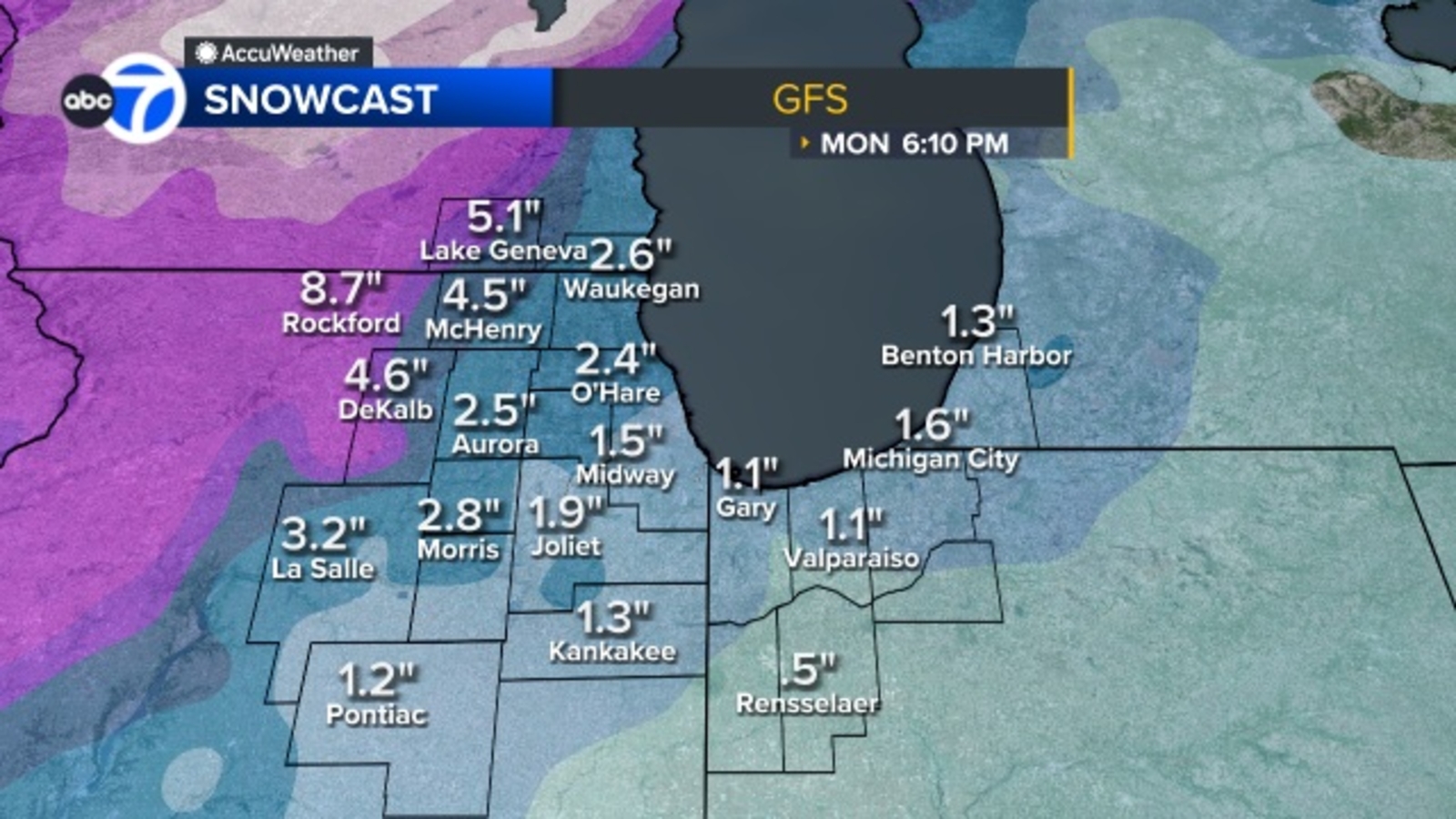
Severe Weather Threat Looms Over Chicago: From Thunderstorms to Snow
Chicago residents are bracing for a dramatic shift in weather conditions as a series of thunderstorms are forecast to sweep through the region on Sunday, transitioning into snow overnight and into Monday morning. The National Weather Service has issued multiple alerts, including a Winter Weather Advisory and a High Wind Warning, signaling potentially hazardous conditions for commuters and those living in vulnerable areas. The approaching storm system promises a complex weather pattern, demanding preparedness from residents across Illinois and Northwest Indiana.
The initial wave of thunderstorms is expected between 9 a.m. And noon, though meteorologists anticipate these storms will weaken as they move further into the city. Though, a second, more concerning round of storms is predicted to develop between 4 p.m. And 9 p.m., bringing the risk of damaging wind gusts. The primary concern with this second wave is the potential for localized wind damage, potentially impacting power lines and causing disruptions to travel. Following this, a third round of storms is anticipated to arrive around 1 a.m. Monday, quickly transitioning to snow as temperatures plummet. This rapid changeover will create icy conditions and reduced visibility for the Monday morning commute.
Winter Weather Advisory and High Wind Warning Details
A Winter Weather Advisory is currently in effect for several counties, including McHenry, Lake (Illinois), Northern Cook, DeKalb, DuPage, Kane, Kendall, and LaSalle, from 10 p.m. Sunday through noon Monday. The National Weather Service warns that accumulations of one to four inches of snow are possible during this period, creating hazardous travel conditions. Drivers are advised to exercise extreme caution and allow for extra travel time. The advisory highlights the potential for slippery roads and reduced visibility, particularly during the morning commute.
Adding to the complexity, a High Wind Warning is in effect for Kankakee County in Illinois and Northwest Indiana from 10 a.m. Sunday until 9 p.m. Sunday. The National Weather Service forecasts wind gusts up to 60 mph, posing a threat to trees, power lines, and unsecured objects. Residents in these areas are urged to secure outdoor furniture and avoid travel if possible. The combination of strong winds and potential thunderstorms creates a dangerous scenario, increasing the risk of power outages and property damage.
Severe Weather Risk Levels and Radar Information
The Storm Prediction Center has indicated that most of the Chicago area is under a Level 2 risk for severe weather, signifying a moderate risk of severe thunderstorms. Northern and northwestern suburbs are at a Level 1 risk, indicating a marginal risk. These risk levels are based on the potential for damaging winds, large hail, and localized flooding. Residents are encouraged to stay informed about the latest weather updates and take appropriate precautions.
Real-time radar information is crucial for tracking the movement of the storms. Here are links to radar maps for various counties in the Chicago area:
- Cook County Radar
- DuPage County Radar
- Will County Radar
- Lake County Radar (IL)
- Kane County Radar
- Northwest Indiana Radar
Preparing for the Changing Conditions
The rapid transition from thunderstorms to snow presents unique challenges for residents. It’s crucial to prepare for both scenarios. For the thunderstorms, residents should secure outdoor objects, seek shelter indoors, and avoid travel during periods of heavy rain and strong winds. As the temperature drops and snow begins to fall, it’s important to dress warmly, clear walkways, and ensure vehicles are equipped with appropriate tires or chains. The Illinois Department of Transportation (IDOT) provides resources for winter driving safety and road conditions.
Power outages are a potential concern given the forecast for strong winds. Residents should have a supply of non-perishable food, water, and essential medications on hand. It’s also advisable to have flashlights, batteries, and a fully charged mobile phone. ComEd, the electric utility serving much of northern Illinois, provides information on outage reporting and safety tips on their website: ComEd.
Impact on Travel and Commuting
The combination of severe weather conditions is expected to significantly impact travel and commuting throughout the Chicago area. Airlines may experience delays or cancellations due to the thunderstorms and snow. Passengers are advised to check with their airlines for the latest flight information. Road conditions are likely to deteriorate rapidly as snow accumulates, making driving hazardous. The Illinois State Police (ISP) urges drivers to reduce their speed, increase their following distance, and avoid unnecessary travel.
Public transportation systems, including Metra and the Chicago Transit Authority (CTA), may also experience delays or disruptions. Passengers should check the websites of these agencies for the latest service updates. The CTA website is https://www.transitchicago.com/ and Metra’s is https://metra.com/. Allowing extra time for commutes and being prepared for potential delays is essential.
Looking Ahead: Continued Monitoring
The weather situation remains dynamic, and forecasts may change. Residents are encouraged to stay informed about the latest updates from the National Weather Service and local news sources. Continued monitoring of the weather conditions is crucial for making informed decisions and ensuring safety throughout the weekend and into the start of the workweek. The next significant update from the National Weather Service is expected Monday morning at 6 a.m. CST.
Have your say! Share your weather preparedness tips and experiences in the comments below. And please, share this article with your friends and family to help them stay safe during this challenging weather event.
- Canadair Fleet Crisis: Maintenance Failures and the Struggle to Fight Wildfires
- Tyler Technologies (NYSE: TYL) Company Overview and Stock Analysis
- Chicago Fire Original Cast Member Joe Miñoso to Exit in Season 15 (time.news)
- Katabatic Winds, Explained: Why Antarctica Is Earth's Windiest Place (daybreakwire.com)