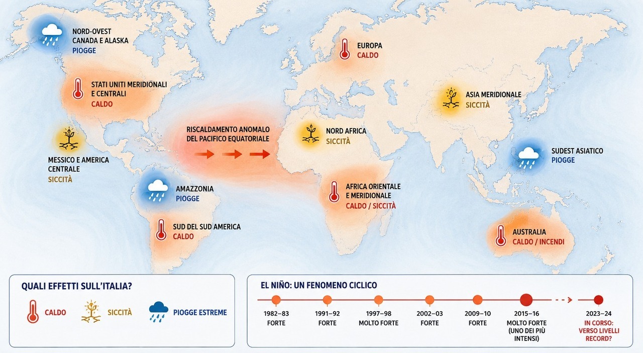
Climate scientists have confirmed that global temperature anomalies are reaching unprecedented levels, driven by a complex interaction between long-term human-induced warming and the cyclical El Niño-Southern Oscillation (ENSO) pattern. While El Niño is a significant driver of weather variability across the Pacific, its direct influence on Italian and European weather remains indirect, primarily manifesting through shifting atmospheric circulation patterns rather than immediate localized climate shifts.
The Mechanics of El Niño and Global Temperature Records
El Niño occurs when sea surface temperatures in the central and eastern Pacific Ocean rise above average, altering global wind patterns and heat distribution. According to the World Meteorological Organization (WMO), 2023 was the warmest year on record, a milestone reached as the planet transitioned into a strong El Niño phase. This phenomenon releases vast amounts of heat from the ocean into the atmosphere, often pushing global mean temperatures to new highs.
The National Oceanic and Atmospheric Administration (NOAA) notes that while El Niño acts as a temporary accelerator for global temperature increases, it sits atop a long-term warming trend caused by greenhouse gas emissions. When these two factors align, the probability of exceeding historical temperature records increases significantly. Scientists monitor these anomalies using satellite data and ocean buoys to track the heat content of the upper layers of the Pacific, providing the baseline for current climate modeling.
Understanding the Impact on Italy
For residents in Italy and the broader Mediterranean region, the relationship with El Niño is nuanced. Meteorologists emphasize that El Niño does not dictate Italian weather in the same direct manner it affects the Americas or parts of Southeast Asia. Instead, its influence is mediated through the North Atlantic Oscillation (NAO) and the jet stream.
According to research from the Institute of Atmospheric Sciences and Climate (ISAC-CNR), Italy’s weather is primarily governed by local topography, the proximity of the Mediterranean Sea, and the variability of Atlantic pressure systems. During an El Niño year, the atmospheric bridge between the Pacific and Europe can lead to shifts in precipitation patterns, but these are rarely consistent enough to be attributed solely to the Pacific phenomenon. The extreme heatwaves often observed in Italy are increasingly linked to stagnant high-pressure systems—often called “heat domes”—which are becoming more frequent due to the overall warming of the troposphere.
Why Extreme Heat is Becoming the New Standard
The convergence of a warmer climate and natural cycles means that extreme weather events are likely to become more frequent. The Intergovernmental Panel on Climate Change (IPCC) Sixth Assessment Report identifies that human-induced climate change is already increasing the intensity and duration of heatwaves globally. In Italy, the “tropicalization” of the climate is characterized by longer periods of sustained high temperatures and more intense, localized precipitation events.
As the world moves out of a strong El Niño phase, scientists continue to observe record-breaking sea surface temperatures globally. The Copernicus Climate Change Service reported that global air temperatures have remained consistently high through the first half of 2024, suggesting that the “El Niño effect” may be lingering or that systemic climate shifts are now dominating the short-term variability of the earth’s thermostat.
Monitoring the Next Climate Phase
The current transition toward La Niña—the cooler counterpart to El Niño—is being monitored closely by meteorological agencies worldwide. While La Niña typically has a slight cooling effect on global average temperatures, historical data suggests that the baseline of global warming is now so high that even “cooler” years are warmer than the averages of the late 20th century. Official updates on the transition to La Niña are expected to be released periodically by the Climate Prediction Center.
Readers interested in local impacts can track official weather advisories through the Servizio Meteorologico dell’Aeronautica Militare, which provides the most accurate, localized data for the Italian territory. As climate patterns continue to evolve, understanding the distinction between long-term trends and cyclical events remains vital for public preparedness. Please share your thoughts or local observations in the comments below.